File:Minamisoma Radiation 2011-11.jpg
From Wikimedia Commons, the free media repository
Jump to navigation
Jump to search
Size of this preview: 571 × 600 pixels. Other resolutions: 228 × 240 pixels | 457 × 480 pixels | 731 × 768 pixels | 975 × 1,024 pixels | 1,288 × 1,353 pixels.
Original file (1,288 × 1,353 pixels, file size: 249 KB, MIME type: image/jpeg)
File information
Structured data
Captions
DescriptionMinamisoma Radiation 2011-11.jpg |
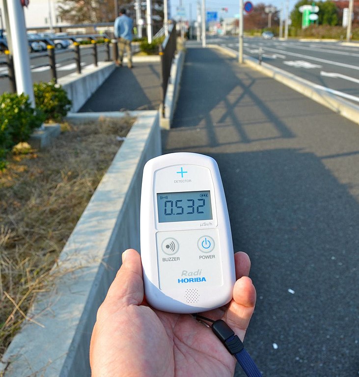
English: Radiation monitor showing radiation at Minamisoma, Fukushima Prefecture, Japan
Deutsch: Geigerzähler mit Dosisleistungsanzeige in Minamisoma, Präfektur Fukushima |
||
Date | |||
Source | https://www.flickr.com/photos/raneko/6343787046/ | ||
Author | osaMu | ||
Permission (Reusing this file) |
This file is licensed under the Creative Commons Attribution 2.0 Generic license.
|
Camera location | 37° 38′ 08.53″ N, 140° 59′ 03.29″ E | View this and other nearby images on: OpenStreetMap | 37.635702; 140.984248 |
---|
File history
Click on a date/time to view the file as it appeared at that time.
Date/Time | Thumbnail | Dimensions | User | Comment | |
---|---|---|---|---|---|
current | 22:03, 14 December 2011 | 1,288 × 1,353 (249 KB) | PM3 (talk | contribs) | crop | |
21:59, 14 December 2011 | 2,047 × 1,356 (291 KB) | PM3 (talk | contribs) | {{Information |Description ={{en|1=Geiger counter showing radiation at Chome, Minamisoma, Fukushima Prefecture, Japan}} {{de|1=Geigerzähler mit Dosisleistungsanzeige in Choma, Stadt Minamisoma, Präfektur Fukushima}} |Source =http://www.flickr |
You cannot overwrite this file.
File usage on Commons
There are no pages that use this file.
File usage on other wikis
The following other wikis use this file:
- Usage on de.wikipedia.org
- Usage on en.wikipedia.org
- Usage on es.wikipedia.org
- Usage on fa.wikipedia.org
- Usage on fr.wikipedia.org
- Usage on ja.wikipedia.org
- Usage on ko.wikipedia.org
- Usage on pt.wikipedia.org
- Usage on uz.wikipedia.org
- Usage on www.wikidata.org
Metadata
This file contains additional information such as Exif metadata which may have been added by the digital camera, scanner, or software program used to create or digitize it. If the file has been modified from its original state, some details such as the timestamp may not fully reflect those of the original file. The timestamp is only as accurate as the clock in the camera, and it may be completely wrong.
Camera manufacturer | NIKON CORPORATION |
---|---|
Camera model | NIKON D7000 |
Exposure time | 1/250 sec (0.004) |
F-number | f/8 |
ISO speed rating | 200 |
Date and time of data generation | 14:43, 4 November 2011 |
Lens focal length | 20 mm |
Latitude | 37° 38′ 8.53″ N |
Longitude | 140° 59′ 3.29″ E |
Altitude | 33 meters above sea level |
Orientation | Normal |
Horizontal resolution | 72 dpi |
Vertical resolution | 72 dpi |
Software used | QuickTime 7.7.1 |
File change date and time | 23:01, 14 December 2011 |
Y and C positioning | Centered |
Exposure Program | Not defined |
Exif version | 2.2 |
Date and time of digitizing | 14:43, 4 November 2011 |
Meaning of each component |
|
Image compression mode | 4 |
APEX exposure bias | 0 |
Maximum land aperture | 3.7 APEX (f/3.61) |
Metering mode | Pattern |
Light source | Unknown |
Flash | Flash did not fire, compulsory flash suppression |
DateTime subseconds | 00 |
DateTimeOriginal subseconds | 00 |
DateTimeDigitized subseconds | 00 |
Supported Flashpix version | 1 |
Color space | sRGB |
Sensing method | One-chip color area sensor |
File source | Digital still camera |
Scene type | A directly photographed image |
Custom image processing | Normal process |
Exposure mode | Auto exposure |
White balance | Auto white balance |
Digital zoom ratio | 1 |
Focal length in 35 mm film | 30 mm |
Scene capture type | Standard |
Contrast | Normal |
Saturation | Normal |
Sharpness | Normal |
Subject distance range | Unknown |
GPS time (atomic clock) | 05:43 |
Satellites used for measurement | 10 |
Geodetic survey data used | WGS 84 |
GPS tag version | 0.0.3.2 |
IIM version | 2 |