File:Milang. Rear view of the Anglican Church. Built in local limestone in 1911. (44195945704).jpg

Original file (4,711 × 3,533 pixels, file size: 3.44 MB, MIME type: image/jpeg)
Captions
Captions
Summary
[edit].jpg&action=edit§ion=1)
| Description |
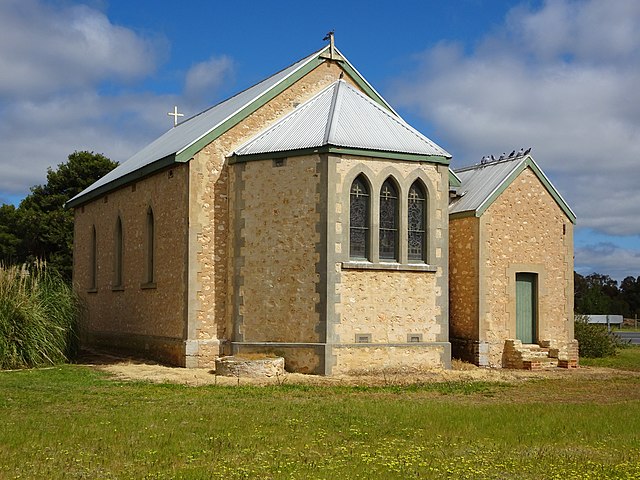
A Brief History of Milang. The settlers of Strathalbyn were anxious to have a port near their town especially after the Wheal Ellen mine began operations in 1857. In August 1853 Captains Cadell and Randell had proved the viability of river trade. In light of this the Surveyor General Arthur Freeling ordered a township to be laid out on the shores of Lake Alexandrina near where the Bremer and Angas rivers enter the lake. A site was selected on high ground away from both river mouths. Milang was laid out by January 1854. The town had a grid pattern, like Adelaide surrounded by parklands on three sides and the lake on the other. Blocks must have sold quickly as in 1857 a private development was laid out beyond the parklands by Dr Rankine of Strathalbyn. The town name was selected from a local Aboriginal word “Millangk” which meant place of sorcery and magic. Some might argue that Milang is still a magical place! Among the purchasers of the first town lots, as was to be the case in Langhorne Creek too, were the elite of Strathalbyn- the Gollans, Stirlings, Dawsons etc. Other pioneers of Milang were the Landseer family and G Chalken. Chalken owned the Lake Hotel, established in 1856 in a side street. The Pier Hotel facing the lake was built in 1857 and still stands. Landseer soon opened a general store and Post Office. He bought machinery from the original Pavy flour mill and built a new one in 1871. Around this time he also erected a large wool store and other warehouses along Duranda Terrace making him the main businessman in town. Milang blossomed overnight on the expectation of successful river trading. A South Australian Register newspaper article in 1857 described the new town thus: “Milang is becoming a very bustling little port and will shortly grow into a place of importance. Already it has two inns, a steam mill, a store of some extent, a chapel in the course of erection, a timber yard and a jetty on which there were lying on Tuesday the Symmetry twenty five tons, the Blue Jacket five tons and the Enterprise eight tons. There are now about one hundred and ten souls in the township and several hundred settlers within a radius of two or three miles. Cultivation is progressing extensively and wheat and flour are continuously shipped, and also silver and lead from Strathalbyn and the Wheal Ellen mines.” Alas Milang is no longer a bustling port or town! As with most other towns the first public structures were the two hotels and the early school room in 1856. This purpose built school is still in use. The first church erected was the Church of Christ in Coxe Street in 1857. This church was enlarged in 1899 and again in 1901. By 1866 Milang had two further churches the Primitive Methodist erected in 1866 in Chapel Street and the Congregational Church erected in 1862 in Stephenson Street. The Congregational Church originally had a thatched roof and it is now the Uniting Church. The Anglican Church was not built until 1911 and its completion was financially assisted by the Dunk family. Before then Anglican services were conducted in the Institute building. Mrs Landseer laid the foundation stone of the Institute in January 1884. James Rankine of Strathalbyn opened the Institute later that year. By 1890 it was free of debt and in 1917 further additions were made to it. A District Council was formed in Milang in 1855 and the first meetings were held in nearby Belvedere. A police station opened in Milang in 1865 but Milang began to slide backwards shortly after that. The tramway to Strathalbyn in 1869 bypassed Milang despite pleas for it to travel via Milang. However they did get a rail line in 1884 to link with the Adelaide line at Sandergrove. In 1893 a butter factory opened in Milang, the Lakeside Butter Factory which exported local butter to England. It closed in 1915. It re-opened some time later and was still operating in the 1930s. The infamous shacks along the lake foreshore were built around 1948. The Milang Progress Association controlled the area until the local Council resumed control in 1967. Despite government threats to their existence the shack owners have had several reprieves and they are still there. |
| Date | |
| Source | Milang. Rear view of the Anglican Church. Built in local limestone in 1911. |
| Author | denisbin from Adelaide, Australia |
| Camera location | | View this and other nearby images on: OpenStreetMap |
|---|
.jpg¶ms=-35.404717_N_0138.968886_E_globe:Earth_type:camera_source:Flickr_&language=en)
Licensing
[edit].jpg&action=edit§ion=2)
| This file is made available under the Creative Commons CC0 1.0 Universal Public Domain Dedication. | |
| The person who associated a work with this deed has dedicated the work to the public domain by waiving all of their rights to the work worldwide under copyright law, including all related and neighboring rights, to the extent allowed by law. You can copy, modify, distribute and perform the work, even for commercial purposes, all without asking permission.
|
| This image was originally posted to Flickr by denisbin at https://flickr.com/photos/82134796@N03/44195945704 (archive). It was reviewed on 10 December 2019 by FlickreviewR 2 and was confirmed to be licensed under the terms of the cc-zero. |
File history
Click on a date/time to view the file as it appeared at that time.
| Date/Time | Thumbnail | Dimensions | User | Comment | |
|---|---|---|---|---|---|
| current | 20:42, 10 December 2019 | | 4,711 × 3,533 (3.44 MB) | Coekon (talk | contribs) | Transferred from Flickr via #flickr2commons |
You cannot overwrite this file.
File usage on Commons
There are no pages that use this file.
.jpg&oldid=702272989)