File:Micronesia and Marshall islands bathymetry, Ļemkein.png
Jump to navigation
Jump to search

No higher resolution available.
Micronesia_and_Marshall_islands_bathymetry,_Ļemkein.png (602 × 422 pixels, file size: 572 KB, MIME type: image/png)
Captions
Captions
Add a one-line explanation of what this file represents
Summary
[edit]| Description | |
| Date | |
| Source | https://ngmdb.usgs.gov/Prodesc/proddesc_33349.htm |
| Author | James R. Hein, Florence L. Wong, Dan L. Mosier, cropped by w:User:Jo-Jo Eumerus |
Licensing
[edit]
This image is in the public domain in the United States because it only contains materials that originally came from the United States Geological Survey, an agency of the United States Department of the Interior. For more information, see the official USGS copyright policy.
|
File history
Click on a date/time to view the file as it appeared at that time.
| Date/Time | Thumbnail | Dimensions | User | Comment | |
|---|---|---|---|---|---|
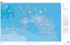
| current | 15:24, 8 December 2018 | | 602 × 422 (572 KB) | Jo-Jo Eumerus (talk | contribs) | {{Information |Description = A bathymetric map of seamounts and islands in Micronesia and the Marshall Islands |Source = https://ngmdb.usgs.gov/Prodesc/proddesc_33349.htm |Date = 1999 |Author = James R. Hein, Florence L. Wong, Dan L. Mosier, cropped by User:Jo-Jo Eumerus }} {{Extracted from|File:Micronesia and Marshall islands bathymetry.pdf}} == Licensing == {{PD-USGov-Interior-USGS}} |
You cannot overwrite this file.
File usage on Commons
There are no pages that use this file.
File usage on other wikis
The following other wikis use this file:
- Usage on en.wikipedia.org
- Usage on www.wikidata.org