File:Mickey Hot Springs (30806570576).jpg

Original file (3,300 × 2,550 pixels, file size: 882 KB, MIME type: image/jpeg)
Captions
Captions
Summary
[edit].jpg&action=edit§ion=1)
| Description |
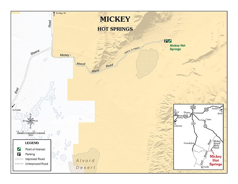
Mickey Hot Springs is a moderately known geothermal area on the northern end of the Alvord Desert. Sometimes there is a plethora of geothermal activity here, and sometimes it is mostly dried up, empty holes – all dependent on the season and recent rainfall. Nearly always, there is a colorful 15-20’ diameter, over 10’ deep, pool – clear with near-boiling water. If the time is right, the ground hisses with steam, releasing pressure from the same geologic fault that created Steens Mountain. Gurgling mud pots and small, glassy streams that heat to as much as 180 degrees are also in the area. Mickey Hot Springs went quietly un-noticed until 1992 when one of the bubbling spots became a mini-geyser. It reached 6-8’ high and received brief national attention as the only natural geyser in Oregon! Remember, this site is for viewing only – any pools are too dangerously hot for soaking. For more information contact: 28910 Hwy 20 West Hines, OR 97738 541-573-4400 BLM_OR_BU_Mail@blm.gov |
| Date | |
| Source | Mickey Hot Springs |
| Author | Bureau of Land Management Oregon and Washington from Portland, America |
Licensing
[edit].jpg&action=edit§ion=2)
- You are free:
- to share – to copy, distribute and transmit the work
- to remix – to adapt the work
- Under the following conditions:
- attribution – You must give appropriate credit, provide a link to the license, and indicate if changes were made. You may do so in any reasonable manner, but not in any way that suggests the licensor endorses you or your use.
| This image was originally posted to Flickr by BLMOregon at https://flickr.com/photos/50169152@N06/30806570576 (archive). It was reviewed on 13 May 2018 by FlickreviewR 2 and was confirmed to be licensed under the terms of the cc-by-2.0. |
| This image is a work of a Bureau of Land Management* employee, taken or made as part of that person's official duties. As a work of the U.S. federal government, the image is in the public domain in the United States. *or predecessor organization |
| This image is a work of a Bureau of Land Management* employee, taken or made as part of that person's official duties. As a work of the U.S. federal government, the image is in the public domain in the United States. *or predecessor organization |
File history
Click on a date/time to view the file as it appeared at that time.
| Date/Time | Thumbnail | Dimensions | User | Comment | |
|---|---|---|---|---|---|
| current | 15:21, 13 May 2018 | | 3,300 × 2,550 (882 KB) | OceanAtoll (talk | contribs) | Transferred from Flickr via #flickr2commons |
You cannot overwrite this file.
File usage on Commons
There are no pages that use this file.
.jpg&oldid=493019556)