File:Metro tunis.svg
Jump to navigation
Jump to search

Size of this PNG preview of this SVG file: 587 × 599 pixels. Other resolutions: 235 × 240 pixels | 470 × 480 pixels | 752 × 768 pixels | 1,003 × 1,024 pixels | 2,006 × 2,048 pixels | 622 × 635 pixels.
Original file (SVG file, nominally 622 × 635 pixels, file size: 556 KB)
Captions
Captions
Add a one-line explanation of what this file represents
Summary
[edit]
| Description |
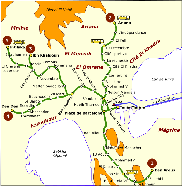
Français : Structure du réseau du métro léger de Tunis (2007). Les cercles blancs et jaunes désignent, respectivement, les stations ordinaires et principales. Le symbole du bus indique une correspondance avec une station de bus. Le triangle rouge correspond à la station de la ligne ferroviaire Tunis-Goulette-Marsa (TGM). Ce plan est inspiré de celui qui est disponible sur le site de la Société des transports de Tunis.
English: Structure of the light rail (métro léger) network of the city of Tunis (2007). The white and yellow circles are respectively ordinary and major stations. The bus symbol indicates that metro station matched to a bus station. The red triangle corresponds to the station of the railway line Tunis-Goulette-Marsa (TGM). This plan is inspired from the one available on the Transportation Company of Tunis website. |
| Date | |
| Source | Own work |
| Author |
This W3C-unspecified vector image was created with Inkscape . |
| Permission (Reusing this file) |
Creative Commons Attribution ShareAlike license (see below). |
Licensing
[edit]
I, the copyright holder of this work, hereby publish it under the following licenses:

|
Permission is granted to copy, distribute and/or modify this document under the terms of the GNU Free Documentation License, Version 1.2 or any later version published by the Free Software Foundation; with no Invariant Sections, no Front-Cover Texts, and no Back-Cover Texts. A copy of the license is included in the section entitled GNU Free Documentation License. |
This file is licensed under the Creative Commons Attribution-Share Alike 3.0 Unported, 2.5 Generic, 2.0 Generic and 1.0 Generic license.
- You are free:
- to share – to copy, distribute and transmit the work
- to remix – to adapt the work
- Under the following conditions:
- attribution – You must give appropriate credit, provide a link to the license, and indicate if changes were made. You may do so in any reasonable manner, but not in any way that suggests the licensor endorses you or your use.
- share alike – If you remix, transform, or build upon the material, you must distribute your contributions under the same or compatible license as the original.
You may select the license of your choice.
File history
Click on a date/time to view the file as it appeared at that time.
| Date/Time | Thumbnail | Dimensions | User | Comment | |
|---|---|---|---|---|---|
| current | 07:06, 8 November 2007 | | 622 × 635 (556 KB) | YassineMrabet (talk | contribs) | Corrections |
| 20:16, 7 November 2007 |  | 622 × 635 (555 KB) | YassineMrabet (talk | contribs) | {{Information |Description={{fr|'''Structure du réseau du métro léger de Tunis''' (2007). Les cercles blanches et jaunes désignent, respectivement, les stations ordinaires et principales. Le symbole du bus indique |
You cannot overwrite this file.
File usage on Commons
There are no pages that use this file.
File usage on other wikis
The following other wikis use this file:
- Usage on fr.wikipedia.org
- Usage on www.wikidata.org