File:Mesolithic tranchet axehead. (FindID 840860).jpg
Jump to navigation
Jump to search

Size of this preview: 608 × 599 pixels. Other resolutions: 244 × 240 pixels | 487 × 480 pixels | 779 × 768 pixels | 1,039 × 1,024 pixels | 2,078 × 2,048 pixels | 7,087 × 6,984 pixels.
Original file (7,087 × 6,984 pixels, file size: 12.95 MB, MIME type: image/jpeg)
Captions
Captions
Add a one-line explanation of what this file represents
Summary
[edit].jpg&action=edit§ion=1)
| Mesolithic tranchet axehead. | |||
|---|---|---|---|
| Photographer |
The Portable Antiquities Scheme, Lucy Bevan, 2017-05-05 13:33:59 |
||
| Title |
Mesolithic tranchet axehead. |
||
| Description |
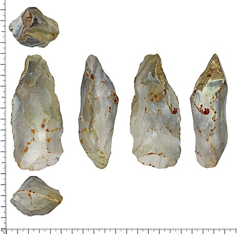
English: A complete tranchet axehead. The axehead is small and irregular. It has a broadly trapezoidal cross section and is crudely parallel sided, tapering to a blunt point at the butt end. Both faces are formed by irregular steep to semi-invasive flaking and the edges are of irregular 'zig-zag' form with only slight battering. The cutting edge is steeply profiled and both offset from, and angled to, the main axis of the axe. Both faces show cross-body, covering flakes, one of which has only partially traversed the axe. Made on light grey mottled flint; an area of worn chalky cortex remains on one face and edge near the butt. Surfaces have a variable glossy thin white patina, more so toward the cutting end of the axe. There are sporadic red-brown ferrous stains all over, primarily along flake scar ridges.
Date: Mesolithic - 10000 to 4000BC. Dimensions: 97mm x 41.5mm x 30mm. Weight: 153g. |
||
| Depicted place | (County of findspot) Dorset | ||
| Date | between 10000 BC and 4000 BC | ||
| Accession number |
FindID: 840860 Old ref: DOR-39CF58 Filename: DOR39CF58.jpg |
||
| Credit line |
|
||
| Source |
https://finds.org.uk/database/ajax/download/id/613746 Catalog: https://finds.org.uk/database/images/image/id/613746/recordtype/artefacts archive copy at the Wayback Machine Artefact: https://finds.org.uk/database/artefacts/record/id/840860 |
||
| Permission (Reusing this file) |
Attribution License version 2.0 (verified 22 November 2020) | ||
| Object location | | View this and other nearby images on: OpenStreetMap |
|---|
.jpg¶ms=050.827600_N_-002.111000_E_globe:Earth_class:object_type:object__&language=en)
Licensing
[edit].jpg&action=edit§ion=2)
This file is licensed under the Creative Commons Attribution 2.0 Generic license.
Attribution: The Portable Antiquities Scheme
- You are free:
- to share – to copy, distribute and transmit the work
- to remix – to adapt the work
- Under the following conditions:
- attribution – You must give appropriate credit, provide a link to the license, and indicate if changes were made. You may do so in any reasonable manner, but not in any way that suggests the licensor endorses you or your use.
File history
Click on a date/time to view the file as it appeared at that time.
| Date/Time | Thumbnail | Dimensions | User | Comment | |
|---|---|---|---|---|---|
| current | 07:38, 16 December 2018 | | 7,087 × 6,984 (12.95 MB) | Fæ (talk | contribs) | Portable Antiquities Scheme, DOR, FindID: 840860, mesolithic, page 1757, batch count 9839 |
You cannot overwrite this file.
File usage on Commons
The following page uses this file:
.jpg)
.jpg&oldid=742057930)