File:Mesolithic tranchet axe-adze (FindID 475309).jpg
Jump to navigation
Jump to search
Size of this preview: 507 × 599 pixels. Other resolutions: 203 × 240 pixels | 406 × 480 pixels | 650 × 768 pixels | 867 × 1,024 pixels | 1,734 × 2,048 pixels | 2,606 × 3,078 pixels.
Original file (2,606 × 3,078 pixels, file size: 2.49 MB, MIME type: image/jpeg)
Captions
Captions
Add a one-line explanation of what this file represents
Summary
[edit].jpg&action=edit§ion=1)
| Mesolithic tranchet axe/adze | |||
|---|---|---|---|
| Photographer |
Winchester Museums Service, Robert Webley, 2011-11-30 11:32:11 |
||
| Title |
Mesolithic tranchet axe/adze |
||
| Description |
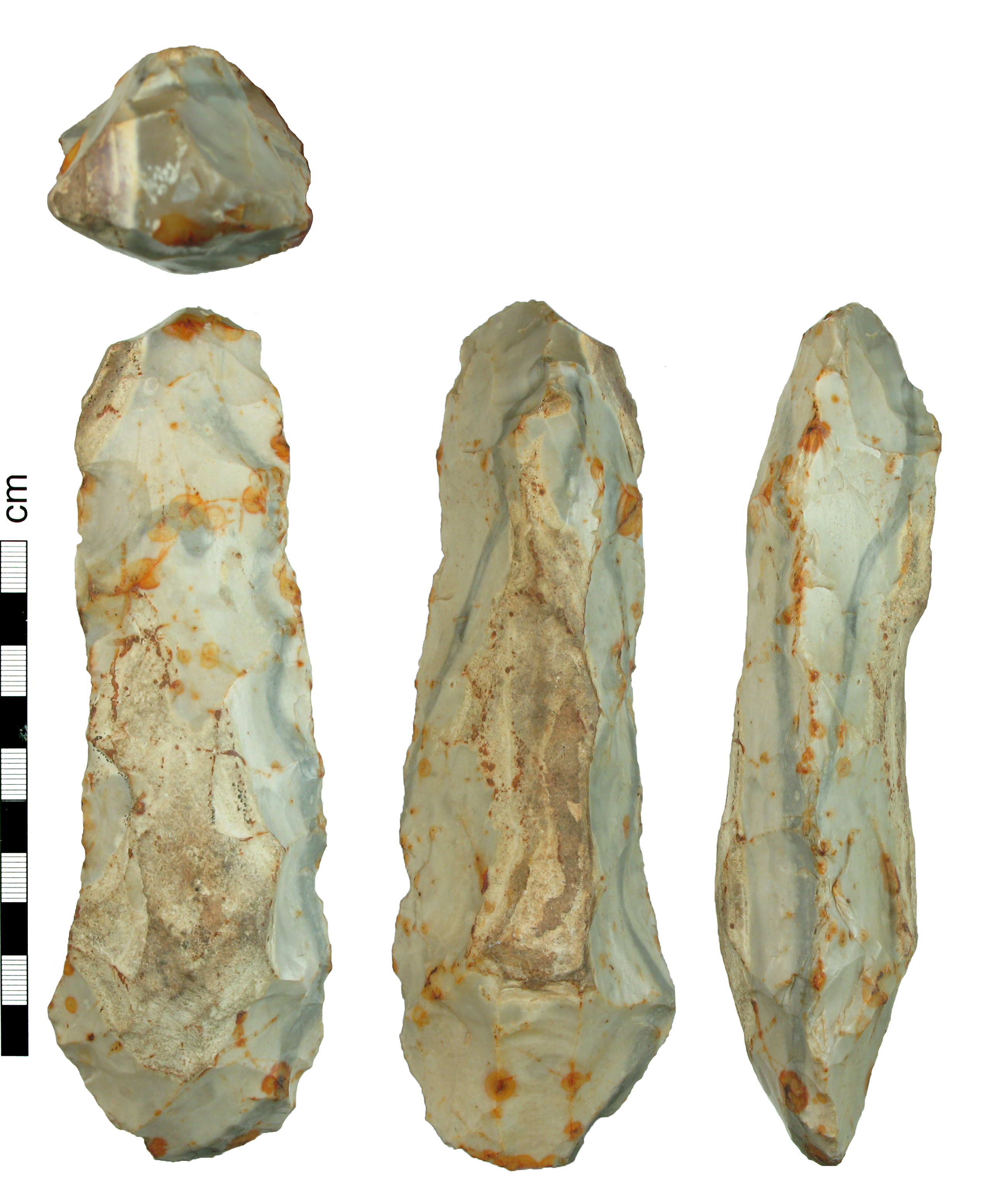
English: A complete knapped flint adze or axehead of Mesolithic date. It has an asymmetrical hexagonal cross-section with a flatter lower surface and more steeply bevelled upper surface. On the central ridge the cortex has been left (these are the surviving surfaces); there is also some cortex at one corner of the butt end. On the upper surface there are three long removals up the tip at the distal end, one central, the others to each side (cf. an adze illustrated in Butler 2005, 106; ref. 42.1). On the lower surface there is what seems to be a 'tranchet' removal, retouched longitudinally to one side. The sides are fairly straight and slightly battered but the removals are generally fairly crisp. The flint is a light-grey colour with some darker seams and patches of orange iron staining. |
||
| Depicted place | (County of findspot) Hampshire | ||
| Date | between 8300 BC and 3500 BC | ||
| Accession number |
FindID: 475309 Old ref: HAMP-614112 Filename: HAMP-614112tranchetaxe.jpg |
||
| Credit line |
|
||
| Source |
https://finds.org.uk/database/ajax/download/id/358374 Catalog: https://finds.org.uk/database/images/image/id/358374/recordtype/artefacts archive copy at the Wayback Machine Artefact: https://finds.org.uk/database/artefacts/record/id/475309 |
||
| Permission (Reusing this file) |
Attribution-ShareAlike License version 4.0 (verified 22 November 2020) | ||
| Object location | | View this and other nearby images on: OpenStreetMap |
|---|
.jpg¶ms=051.007500_N_-001.574570_E_globe:Earth_class:object_type:object__&language=en)
Licensing
[edit].jpg&action=edit§ion=2)
This file is licensed under the Creative Commons Attribution-Share Alike 4.0 International license.
Attribution: The Portable Antiquities Scheme/ The Trustees of the British Museum
- You are free:
- to share – to copy, distribute and transmit the work
- to remix – to adapt the work
- Under the following conditions:
- attribution – You must give appropriate credit, provide a link to the license, and indicate if changes were made. You may do so in any reasonable manner, but not in any way that suggests the licensor endorses you or your use.
- share alike – If you remix, transform, or build upon the material, you must distribute your contributions under the same or compatible license as the original.
File history
Click on a date/time to view the file as it appeared at that time.
| Date/Time | Thumbnail | Dimensions | User | Comment | |
|---|---|---|---|---|---|
| current | 23:27, 3 February 2017 | | 2,606 × 3,078 (2.49 MB) | Fæ (talk | contribs) | Portable Antiquities Scheme, HAMP, FindID: 475309, mesolithic, page 6969, batch primary count 45844 |
You cannot overwrite this file.
File usage on Commons
The following page uses this file:
.jpg)
.jpg&oldid=816070400)