File:Mesolithic axe or adze (plan, profile and reverse). (FindID 270655).jpg
Jump to navigation
Jump to search
Size of this preview: 800 × 484 pixels. Other resolutions: 320 × 194 pixels | 640 × 387 pixels | 1,024 × 619 pixels | 1,280 × 774 pixels | 2,560 × 1,548 pixels | 3,386 × 2,048 pixels.
Original file (3,386 × 2,048 pixels, file size: 762 KB, MIME type: image/jpeg)
Captions
Captions
Add a one-line explanation of what this file represents
Summary
[edit]._(FindID_270655).jpg&action=edit§ion=1)
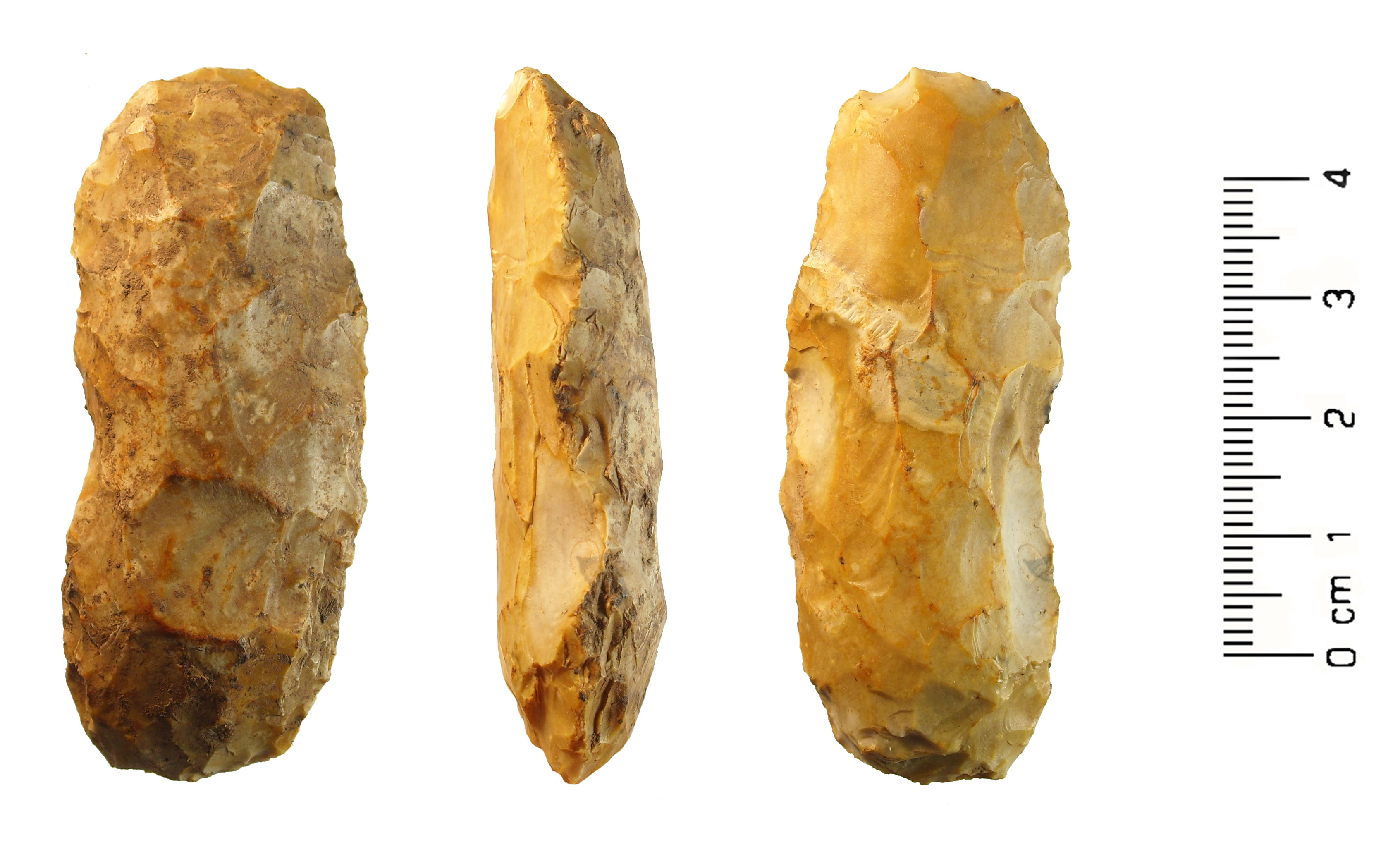
| Mesolithic axe or adze (plan, profile and reverse). | |||
|---|---|---|---|
| Photographer |
Birmingham Museums Trust, Angie Bolton, 2009-10-19 08:59:35 |
||
| Title |
Mesolithic axe or adze (plan, profile and reverse). |
||
| Description |
English: An unfinished flint or chert tranchet axe of Mesolithic date. The axe is knapped from a heavily patinated flint or chert whose surface is mainly a mottled brown/yellow colour. Where there is recent damage the colour is a mottled light grey. In plan the axe is a sub-oval and is a sub-oval in section. The dorsal and ventral faces are covered with negative flake scars, but there is not a bifacial flake at the blade end, therefore it is considered to be an unfinished axe (Phil Watson pers comm). It measures 101.11mm length, 43.21mm width, and is 23.74mm thick. The fragment weighs 128g. The axe has large rough scars on the dorsal and ventral face. Phil Watson (Birmingham Museum and Art Gallery) dates this perform to the Mesolithic period (-8300 to -4500). Butler (Butler, C. 2005 Prehistoric Flintwork Tempus, p.103) illustrates a similar implement and suggests it is either a Mesolithic axe or adze. |
||
| Depicted place | (County of findspot) Warwickshire | ||
| Date | between 8300 BC and 4500 BC | ||
| Accession number |
FindID: 270655 Old ref: WAW-91AC18 Filename: WAW-91AC18.jpg |
||
| Credit line |
|
||
| Source |
https://finds.org.uk/database/ajax/download/id/225023 Catalog: https://finds.org.uk/database/images/image/id/225023/recordtype/artefacts archive copy at the Wayback Machine Artefact: https://finds.org.uk/database/artefacts/record/id/270655 |
||
| Permission (Reusing this file) |
Attribution-ShareAlike License | ||
| Object location | | View this and other nearby images on: OpenStreetMap |
|---|
._(FindID_270655).jpg¶ms=052.244300_N_-001.789550_E_globe:Earth_class:object_type:object__&language=en)
Licensing
[edit]._(FindID_270655).jpg&action=edit§ion=2)
This file is licensed under the Creative Commons Attribution-Share Alike 2.0 Generic license.
Attribution: The Portable Antiquities Scheme/ The Trustees of the British Museum
- You are free:
- to share – to copy, distribute and transmit the work
- to remix – to adapt the work
- Under the following conditions:
- attribution – You must give appropriate credit, provide a link to the license, and indicate if changes were made. You may do so in any reasonable manner, but not in any way that suggests the licensor endorses you or your use.
- share alike – If you remix, transform, or build upon the material, you must distribute your contributions under the same or compatible license as the original.
File history
Click on a date/time to view the file as it appeared at that time.
| Date/Time | Thumbnail | Dimensions | User | Comment | |
|---|---|---|---|---|---|
| current | 05:09, 30 January 2017 | | 3,386 × 2,048 (762 KB) | Fæ (talk | contribs) | Portable Antiquities Scheme, WAW, FindID: 270655, mesolithic, page 1476, batch count 6617 |
You cannot overwrite this file.
File usage on Commons
The following page uses this file:
._(FindID_270655).jpg)
._(FindID_270655).jpg&oldid=742057873)