File:Mesa Verde National Park, Colorado from Flight (14518418343).jpg

Original file (4,000 × 3,000 pixels, file size: 2.64 MB, MIME type: image/jpeg)
Captions
Captions
Summary
[edit].jpg&action=edit§ion=1)
| Description |
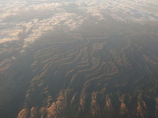
Mesa Verde National Park is a U.S. National Park and UNESCO World Heritage Site located in Montezuma County, Colorado, United States. It is the largest archaeological preserve in the United States. The park was created in 1906 by President Theodore Roosevelt to protect some of the best-preserved cliff dwellings in the world, or as he said, "preserve the works of man". It is the only cultural National Park set aside by the National Park System. It occupies 81.4 square miles (211 km2) near the Four Corners and features numerous ruins of homes and villages built by the Ancient Pueblo peoples, sometimes called the Anasazi. There are over 4000 archaeological sites and over 600 cliff dwellings of the Pueblo people at the site. The Anasazi inhabited Mesa Verde between 600 to 1300, though there is evidence they left before the start of the 15th century. They were mainly subsistence farmers, growing crops on nearby mesas. Their primary crop was corn, the major part of their diet. Men were also hunters, which further increased their food supply. The women of the Anasazi are famous for their elegant basket weaving. Anasazi pottery is as famous as their baskets; their artifacts are highly prized. The Anasazi kept no written records. By the year 750 the people were building mesa-top villages made of adobe. In the late 1190s they began to build the cliff dwellings for which Mesa Verde is famous. Mesa Verde is best known for cliff dwellings, which are structures built within caves and under outcroppings in cliffs — including Cliff Palace, thought to be the largest cliff dwelling in North America. The Spanish term Mesa Verde translates into English as "green table". It is considered to contain some of the most notable and best preserved archaeological sites. en.wikipedia.org/wiki/Mesa_Verde_National_Park en.wikipedia.org/wiki/Wikipedia:Text_of_Creative_Commons_... |
| Date | |
| Source | Mesa Verde National Park, Colorado from Flight |
| Author | Ken Lund from Reno, Nevada, USA |
| Camera location | | View this and other nearby images on: OpenStreetMap |
|---|
.jpg¶ms=037.294703_N_-108.431337_E_globe:Earth_type:camera_source:Flickr_&language=en)
Licensing
[edit].jpg&action=edit§ion=2)
- You are free:
- to share – to copy, distribute and transmit the work
- to remix – to adapt the work
- Under the following conditions:
- attribution – You must give appropriate credit, provide a link to the license, and indicate if changes were made. You may do so in any reasonable manner, but not in any way that suggests the licensor endorses you or your use.
- share alike – If you remix, transform, or build upon the material, you must distribute your contributions under the same or compatible license as the original.
| This image was originally posted to Flickr by Ken Lund at https://flickr.com/photos/75683070@N00/14518418343. It was reviewed on 4 December 2015 by FlickreviewR and was confirmed to be licensed under the terms of the cc-by-sa-2.0. |
File history
Click on a date/time to view the file as it appeared at that time.
| Date/Time | Thumbnail | Dimensions | User | Comment | |
|---|---|---|---|---|---|
| current | 03:55, 4 December 2015 | | 4,000 × 3,000 (2.64 MB) | INeverCry (talk | contribs) | Transferred from Flickr via Flickr2Commons |
You cannot overwrite this file.
File usage on Commons
There are no pages that use this file.
.jpg&oldid=906212435)