File:Merseyrail Map.svg
Jump to navigation
Jump to search

Size of this PNG preview of this SVG file: 672 × 599 pixels. Other resolutions: 269 × 240 pixels | 538 × 480 pixels | 861 × 768 pixels | 1,148 × 1,024 pixels | 2,296 × 2,048 pixels | 740 × 660 pixels.
Original file (SVG file, nominally 740 × 660 pixels, file size: 673 KB)
Captions
Captions
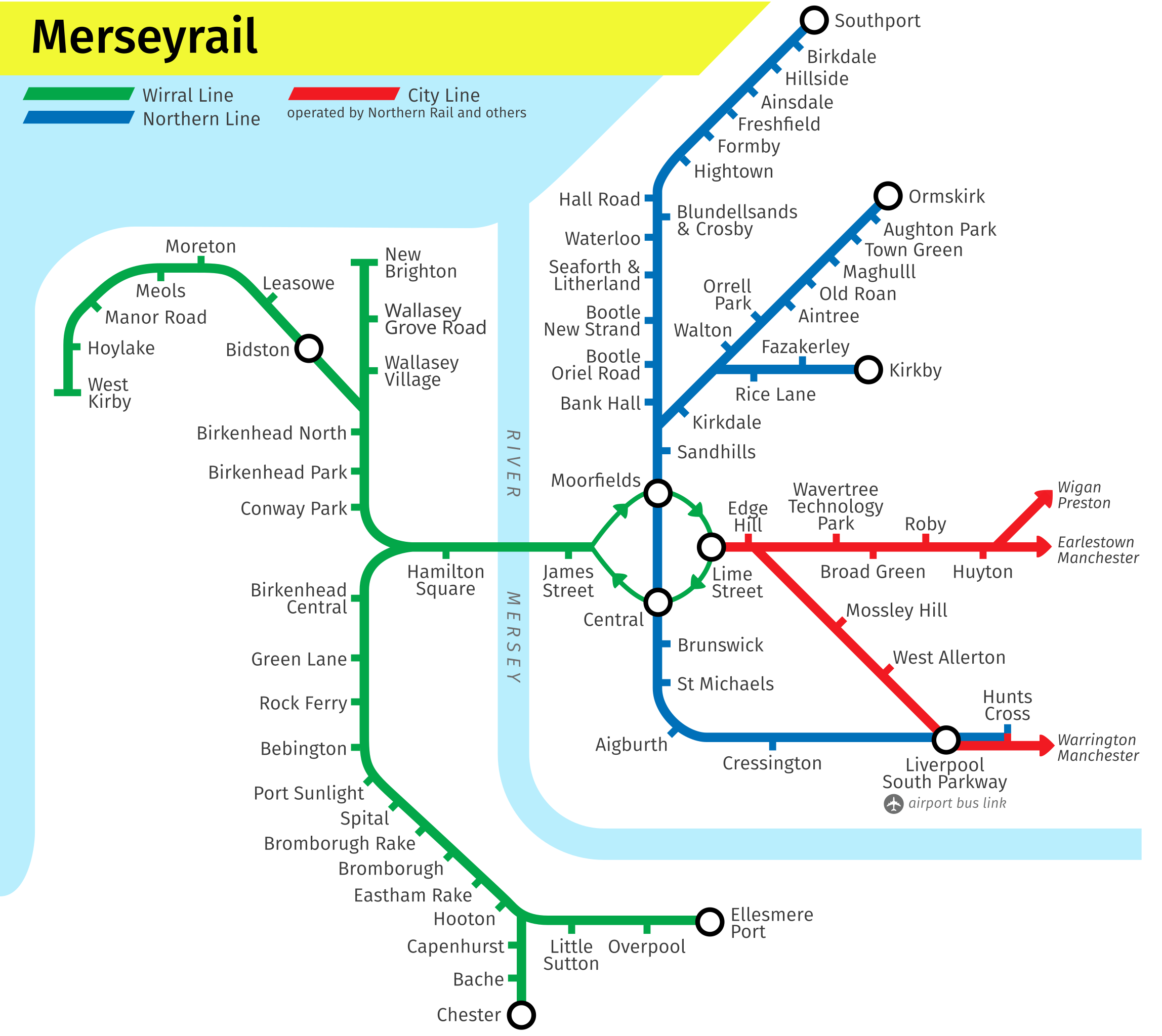
This map is missing the relatively new Maghull North station and Headbolt Lane
Summary
[edit]
| Description | A map of the Merseyrail network in Liverpool. |
| Date | |
| Source | Own work |
| Author | DavidArthur |
Licensing
[edit]
I, the copyright holder of this work, hereby publish it under the following licenses:

|
Permission is granted to copy, distribute and/or modify this document under the terms of the GNU Free Documentation License, Version 1.2 or any later version published by the Free Software Foundation; with no Invariant Sections, no Front-Cover Texts, and no Back-Cover Texts. A copy of the license is included in the section entitled GNU Free Documentation License. |
This file is licensed under the Creative Commons Attribution-Share Alike Attribution-Share Alike 4.0 International, 3.0 Unported, 2.5 Generic, 2.0 Generic and 1.0 Generic license.
- You are free:
- to share – to copy, distribute and transmit the work
- to remix – to adapt the work
- Under the following conditions:
- attribution – You must give appropriate credit, provide a link to the license, and indicate if changes were made. You may do so in any reasonable manner, but not in any way that suggests the licensor endorses you or your use.
- share alike – If you remix, transform, or build upon the material, you must distribute your contributions under the same or compatible license as the original.
You may select the license of your choice.
File history
Click on a date/time to view the file as it appeared at that time.
| Date/Time | Thumbnail | Dimensions | User | Comment | |
|---|---|---|---|---|---|
| current | 19:01, 24 June 2015 | | 740 × 660 (673 KB) | DavidArthur (talk | contribs) | Light cleanup & modernisation |
| 20:11, 12 November 2007 |  | 740 × 660 (113 KB) | DavidArthur (talk | contribs) | ||
| 20:09, 12 November 2007 |  | 740 × 660 (113 KB) | DavidArthur (talk | contribs) | ||
| 20:04, 12 November 2007 |  | 740 × 660 (113 KB) | DavidArthur (talk | contribs) | {{Information |Description=A map of the en:Merseyrail network in Liverpool. |Source=self-made |Date=12 November 2007 |Author= DavidArthur |Permission= |other_versions= }} Category:Merseyrail |
You cannot overwrite this file.
File usage on Commons
The following 4 pages use this file:
File usage on other wikis
The following other wikis use this file:
- Usage on cy.wikipedia.org
- Usage on de.wikipedia.org
- Usage on de.wikivoyage.org
- Usage on en.wikipedia.org
- Liverpool Lime Street railway station
- Birkenhead Hamilton Square railway station
- Northern line (Merseyrail)
- Wirral line
- West Kirby railway station
- Bidston railway station
- New Brighton railway station
- Conway Park railway station
- Birkenhead Park railway station
- Chester railway station
- Hooton railway station
- Aintree railway station
- Rock Ferry railway station
- User:DavidArthur/Public transport maps
- Urban rail in the United Kingdom
- Liverpool city centre
- Liverpool station group
- Usage on en.wikivoyage.org
- Usage on eo.wikipedia.org
- Usage on es.wikipedia.org
- Usage on es.wikivoyage.org
- Usage on eu.wikipedia.org
- Usage on fi.wikipedia.org
- Usage on fr.wikipedia.org
- Usage on fr.wikivoyage.org
- Usage on he.wikivoyage.org
- Usage on it.wikivoyage.org
- Usage on ja.wikipedia.org
- Usage on ja.wikivoyage.org
- Usage on nl.wikipedia.org
- Usage on nl.wikivoyage.org
- Usage on pl.wikipedia.org
- Usage on pl.wikivoyage.org
- Usage on pt.wikipedia.org
- Usage on ru.wikipedia.org
- Usage on zh.wikipedia.org
- Usage on zh.wikivoyage.org