File:Meersporigheid-v1.4.PNG
From Wikimedia Commons, the free media repository
Jump to navigation
Jump to search
Meersporigheid-v1.4.PNG (450 × 522 pixels, file size: 41 KB, MIME type: image/png)
File information
Structured data
Captions
Captions
Add a one-line explanation of what this file represents
Summary
[edit]
|
This transport map image could be re-created using vector graphics as an SVG file. This has several advantages; see Commons:Media for cleanup for more information. If an SVG form of this image is available, please upload it and afterwards replace this template with
{{vector version available|new image name}}.
It is recommended to name the SVG file “Meersporigheid-v1.4.svg”—then the template Vector version available (or Vva) does not need the new image name parameter. |
| DescriptionMeersporigheid-v1.4.PNG |
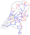
Nederlands: Kaart waarop het aantal sporen per lijn in het Nederlandse spoorwegnetwerk te vinden is.
English: A map with the amount of rails on a line in the Dutch railway network. |
| Date | |
| Source | Own work + File:Meersporigheid-v1.3.png |
| Author | (Original text: T Houtdijk voor versie 1.3, ik heb deze bewerkt tot versie 1.4) |
Licensing
[edit]| Public domainPublic domainfalsefalse |
| This work has been released into the public domain by its author, Treinfan at Dutch Wikipedia. This applies worldwide. In some countries this may not be legally possible; if so: Treinfan grants anyone the right to use this work for any purpose, without any conditions, unless such conditions are required by law.Public domainPublic domainfalsefalse |
Original upload log
[edit](All user names refer to nl.wikipedia)
- 2007-06-05 16:15 Treinfan 450×522×8 (36127 bytes) {{Information |Description=kaart waarop het aantal sporen per lijn in het nederlandse spoorwegnetwerk te vinden is |Source=http://nl.wikipedia.org/wiki/Afbeelding:Meersporigheid-v1.3.png |Date=5 juni 2007 |Author=T Houtdijk voor versie 1.3, ik heb deze be
File history
Click on a date/time to view the file as it appeared at that time.
| Date/Time | Thumbnail | Dimensions | User | Comment | |
|---|---|---|---|---|---|
| current | 15:47, 23 December 2012 |  | 450 × 522 (41 KB) | Wim1234567890 (talk | contribs) | Hanzelijn, Betuweroute en HSL added. |
| 09:45, 20 August 2010 |  | 450 × 522 (35 KB) | Crownsteler~commonswiki (talk | contribs) | updated the map to include the completed work on doubling the tracks from Utrecht to Woerden to 4 tracks. | |
| 12:45, 4 May 2009 |  | 450 × 522 (35 KB) | T Houdijk (talk | contribs) | Removed Hofpleinlijn/Zoetermeerlijn. Some other little things changed. | |
| 19:25, 17 June 2007 |  | 450 × 522 (35 KB) | Kameraad Pjotr (talk | contribs) | {{Information |Description={{nl|Kaart waarop het aantal sporen per lijn in het Nederlandse spoorwegnetwerk te vinden is.}} {{en|A map with the amount of rails on a line in the Dutch railway network.}} |Source=Originally fro |
You cannot overwrite this file.
File usage on Commons
There are no pages that use this file.
File usage on other wikis
The following other wikis use this file:
- Usage on de.wikipedia.org
- Usage on en.wikipedia.org
- Usage on hu.wikipedia.org
- Usage on ja.wikipedia.org
Metadata
This file contains additional information such as Exif metadata which may have been added by the digital camera, scanner, or software program used to create or digitize it. If the file has been modified from its original state, some details such as the timestamp may not fully reflect those of the original file. The timestamp is only as accurate as the clock in the camera, and it may be completely wrong.
| Horizontal resolution | 37.79 dpc |
|---|---|
| Vertical resolution | 37.79 dpc |
| Software used |