File:Mediterraneo centrale 300 a.C. - epoca di Agatocle.png
Jump to navigation
Jump to search

Size of this preview: 800 × 523 pixels. Other resolutions: 320 × 209 pixels | 640 × 419 pixels | 1,024 × 670 pixels | 1,280 × 837 pixels | 1,639 × 1,072 pixels.
Original file (1,639 × 1,072 pixels, file size: 1.72 MB, MIME type: image/png)
Captions
Captions
Add a one-line explanation of what this file represents
Summary
[edit]
| Description |
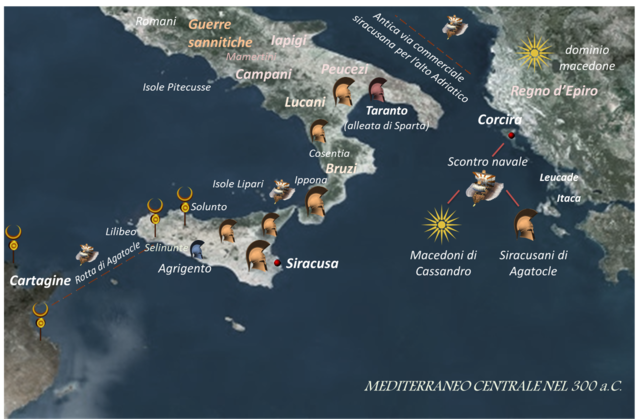
Italiano: Mediterraneo centrale 300 a.C. - epoca di Agatocle |
| Date | |
| Source | Own work |
| Author | Stella |
Licensing
[edit]
I, the copyright holder of this work, hereby publish it under the following license:
This file is licensed under the Creative Commons Attribution-Share Alike 4.0 International license.
- You are free:
- to share – to copy, distribute and transmit the work
- to remix – to adapt the work
- Under the following conditions:
- attribution – You must give appropriate credit, provide a link to the license, and indicate if changes were made. You may do so in any reasonable manner, but not in any way that suggests the licensor endorses you or your use.
- share alike – If you remix, transform, or build upon the material, you must distribute your contributions under the same or compatible license as the original.
File history
Click on a date/time to view the file as it appeared at that time.
| Date/Time | Thumbnail | Dimensions | User | Comment | |
|---|---|---|---|---|---|
| current | 14:36, 30 June 2017 | | 1,639 × 1,072 (1.72 MB) | Stella (talk | contribs) | User created page with UploadWizard |
You cannot overwrite this file.
File usage on Commons
There are no pages that use this file.
File usage on other wikis
The following other wikis use this file:
- Usage on it.wikipedia.org
Metadata
Categories:
- Agathocles of Syracuse
- Maps of the history of ancient Sicily
- Maps of the history of the Mediterranean
- Maps of the Adriatic Sea
- Carthaginian civilization
- Maps of the Ionian Sea
- Maps of Magna Graecia
- Old Maps of the Italian Peninsula in History
- Maps of Southern Italy in History
- Roman conquest of Italy
- Maps of Syrakousai
- History of Syrakousai