File:Mediterranean Sea and NE Atlantic RMG K1004.jpg

Original file (1,280 × 832 pixels, file size: 1.24 MB, MIME type: image/jpeg)
Captions
Captions
Summary
[edit]| Author |
Bertran, Jacopo; Ripol, Berenguer |
| Description |
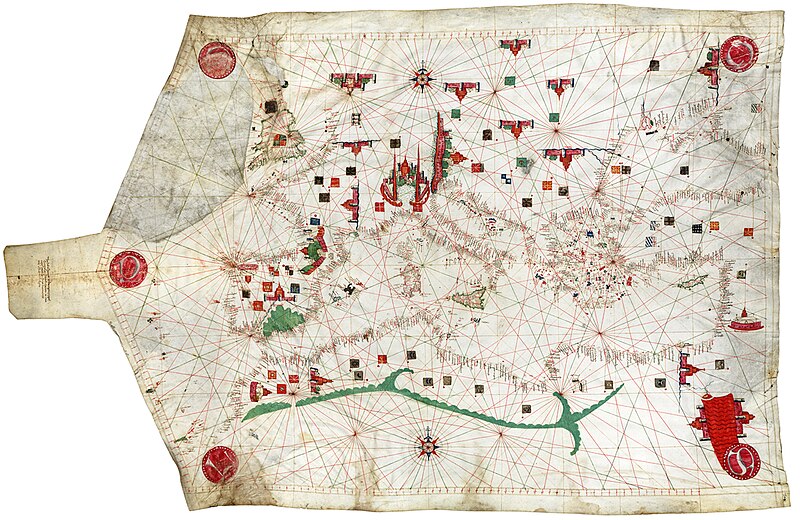
English: [Mediterranean Sea and NE Atlantic] Single sheet. Col. ms. Medium: Vellum. Contents Note: Decoration: winds, cities, Atlas mountains. The Red Sea is painted red. This is the oldest portolan chart in the National Maritime Museum's collections. These charts originated in the Mediterranean in the thirteenth century and take their name from the written sailing directions, 'portolani', which they supplemented and superseded. They were drawn and painted on vellum, using a network of intersecting rhumb (direction) lines radiating out from compass roses. Characteristic features include place names tightly packed onto the coast, together with flags and banners and vignettes of cities. Particularly prominent in this chart are Santiago de Compostela, Barcelona, Avignon (Auinyo), Genoa, Venice, Jerusalem (Santepulcia), Cairo, and Fez. The chart has certain features which are distinctive in the work of the Catalan school of cartography, of which Berenguer and Ripol were a part. These include the waved appearance of the Red Sea, the green, snake--like appearance of the Atlas mountains, and the 'disks of the winds' at the four corners and the neck (Greco, Silocho, Libeco, Maestro). |
| Date | 1456 |
| Dimensions | 98 x 63cm |
| Source/Photographer | http://collections.rmg.co.uk/collections/objects/540297 |
| Permission (Reusing this file) |
The original artefact or artwork has been assessed as public domain by age, and faithful reproductions of the two dimensional work are also public domain. No permission is required for reuse for any purpose. The text of this image record has been derived from the Royal Museums Greenwich catalogue and image metadata. Individual data and facts such as date, author and title are not copyrightable, but reuse of longer descriptive text from the catalogue may not be considered fair use. Reuse of the text must be attributed to the "National Maritime Museum, Greenwich, London" and a Creative Commons CC-BY-NC-SA-3.0 license may apply if not rewritten. Refer to Royal Museums Greenwich copyright. |
| Other versions |
|
| Identifier | Acquisition Number: N38-129C (ex P20) id number: G230:1/7 |
| Collection | Charts and maps |

Licensing
[edit]
|
This is a faithful photographic reproduction of a two-dimensional, public domain work of art. The work of art itself is in the public domain for the following reason:
The official position taken by the Wikimedia Foundation is that "faithful reproductions of two-dimensional public domain works of art are public domain".
This photographic reproduction is therefore also considered to be in the public domain in the United States. In other jurisdictions, re-use of this content may be restricted; see Reuse of PD-Art photographs for details. | ||||
File history
Click on a date/time to view the file as it appeared at that time.
| Date/Time | Thumbnail | Dimensions | User | Comment | |
|---|---|---|---|---|---|
| current | 08:41, 12 September 2017 | | 1,280 × 832 (1.24 MB) | Fæ (talk | contribs) | Royal Museums Greenwich Charts and maps, http://collections.rmg.co.uk/collections/objects/540297 #2976-2 |
You cannot overwrite this file.
File usage on Commons
The following 4 pages use this file:
_RMG_K1004.jpg&redirect=no)