File:Medieval ring (FindID 974241).jpg
Jump to navigation
Jump to search

Size of this preview: 800 × 402 pixels. Other resolutions: 320 × 161 pixels | 640 × 322 pixels | 1,024 × 515 pixels | 1,280 × 643 pixels | 2,185 × 1,098 pixels.
Original file (2,185 × 1,098 pixels, file size: 560 KB, MIME type: image/jpeg)
Captions
Captions
Add a one-line explanation of what this file represents
Summary
[edit].jpg&action=edit§ion=1)
| Medieval ring | |||
|---|---|---|---|
| Photographer |
Derby Museums Trust, Maria Kneafsey, 2019-10-08 15:09:16 |
||
| Title |
Medieval ring |
||
| Description |
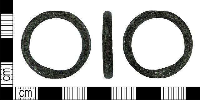
English: A complete, copper alloy ring dating to the medieval or post-medieval periods (c. AD 1200-1800). The ring is broadly circular on the outer edge, with one small but particularly worn and flat section. The inner edge is sub-circular as a result of considerable wear in two places; it is possible that the ring was suspended from these points. The ring is hexagonal in cross-section. Filemarks are clearly visible on the outer edge, and the ring has a deep green surface patina. Cf. <a href="https://finds.org.uk/database/artefacts/record/id/961640">SWYOR-32029E</a> and <a href="https://finds.org.uk/database/artefacts/record/id/767111">SWYOR-9F7F7E</a>.
Diameter: 27.20mm, thickness: 3.68mm, weight: 6.01g. |
||
| Depicted place | (County of findspot) Rotherham | ||
| Date | between 1200 and 1800 | ||
| Accession number |
FindIdentifier: 974241 |
||
| Credit line |
|
||
| Source |
https://finds.org.uk/database/ajax/download/id/1076089 Catalog: https://finds.org.uk/database/images/image/id/1076089/recordtype/artefacts archive copy at the Wayback Machine Artefact: https://finds.org.uk/database/artefacts/record/id/974241 |
||
| Permission (Reusing this file) |
Attribution License version 2.0 (verified 30 November 2020) | ||
| Object location | | View this and other nearby images on: OpenStreetMap |
|---|
.jpg¶ms=053.320100_N_-001.209610_E_globe:Earth_class:object_type:object__&language=en)
Licensing
[edit].jpg&action=edit§ion=2)
This file is licensed under the Creative Commons Attribution 2.0 Generic license.
Attribution: Derby Museums Trust
- You are free:
- to share – to copy, distribute and transmit the work
- to remix – to adapt the work
- Under the following conditions:
- attribution – You must give appropriate credit, provide a link to the license, and indicate if changes were made. You may do so in any reasonable manner, but not in any way that suggests the licensor endorses you or your use.
File history
Click on a date/time to view the file as it appeared at that time.
| Date/Time | Thumbnail | Dimensions | User | Comment | |
|---|---|---|---|---|---|
| current | 17:09, 30 November 2020 | | 2,185 × 1,098 (560 KB) | Fæ (talk | contribs) | Portable Antiquities Scheme, DENO, FindID: 974241-1076089, medieval, page 1324, batch count 23051 |
You cannot overwrite this file.
File usage on Commons
The following page uses this file:
.jpg)
.jpg&oldid=549465070)