File:Medieval lead papal bulla (FindID 494524).jpg
Jump to navigation
Jump to search
Size of this preview: 788 × 599 pixels. Other resolutions: 316 × 240 pixels | 631 × 480 pixels | 1,010 × 768 pixels | 1,280 × 974 pixels | 1,935 × 1,472 pixels.
Original file (1,935 × 1,472 pixels, file size: 1.11 MB, MIME type: image/jpeg)
Captions
Captions
Add a one-line explanation of what this file represents
Summary
[edit].jpg&action=edit§ion=1)
| Medieval lead papal bulla | |||
|---|---|---|---|
| Photographer |
Lincolnshire County Council, Adam Daubney, 2012-03-19 11:47:26 |
||
| Title |
Medieval lead papal bulla |
||
| Description |
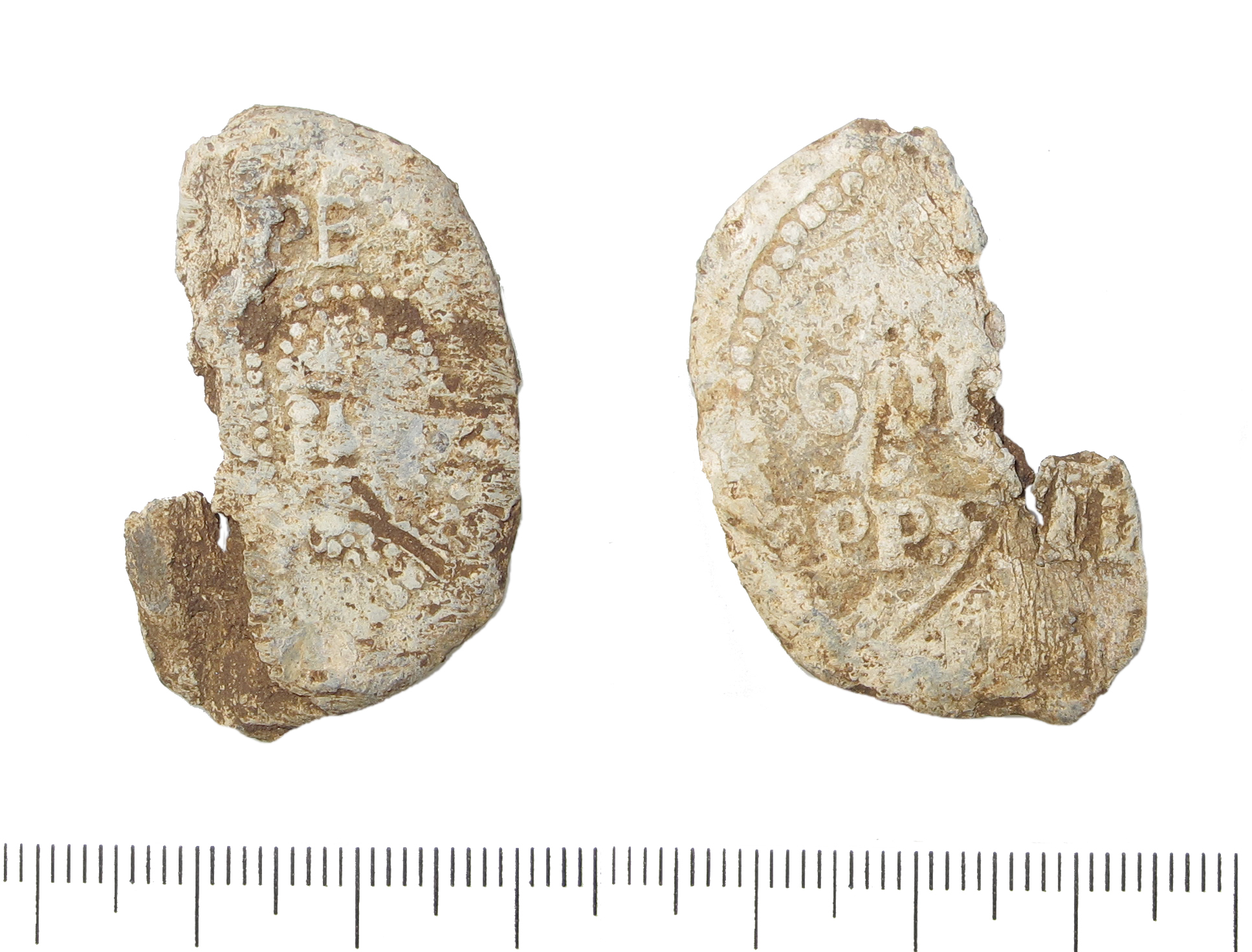
English: Approximately half of a lead papal bulla, probably of Pope Gregory IX (1227-1241). The right-half of the obverse remains which displays the bust of St Peter within a beaded border. The bust of St Paul wuold originally have decorated the left side of the obverse. Above the bust is the inscription [SPAS]PE, abbreviations for St Paul and St Peter. The reverse has the inscription of the pope [GRE]/GOR[IUS]/PP VII[II]. 'PP' is an abbreviation for pastor pastorum, which translates as 'shepherd of the shepherds'. The bulla appears to have been cut in half along the line of the central hole through which a cord would ahve originally been threaded.
Papal bullae were used as seals on official papal documents to authenticate their provenance and authority and were often reused as religious amulets. |
||
| Depicted place | (County of findspot) Lincolnshire | ||
| Date | between 1227 and 1241 | ||
| Accession number |
FindID: 494524 Old ref: LIN-71C973 Filename: LIN2012-338.jpg |
||
| Credit line |
|
||
| Source |
https://finds.org.uk/database/ajax/download/id/374634 Catalog: https://finds.org.uk/database/images/image/id/374634/recordtype/artefacts archive copy at the Wayback Machine Artefact: https://finds.org.uk/database/artefacts/record/id/494524 |
||
| Permission (Reusing this file) |
Attribution-ShareAlike License version 4.0 (verified 17 November 2020) | ||
| Object location | | View this and other nearby images on: OpenStreetMap |
|---|
.jpg¶ms=053.310800_N_-000.496181_E_globe:Earth_class:object_type:object__&language=en)
Licensing
[edit].jpg&action=edit§ion=2)
This file is licensed under the Creative Commons Attribution-Share Alike 4.0 International license.
Attribution: The Portable Antiquities Scheme/ The Trustees of the British Museum
- You are free:
- to share – to copy, distribute and transmit the work
- to remix – to adapt the work
- Under the following conditions:
- attribution – You must give appropriate credit, provide a link to the license, and indicate if changes were made. You may do so in any reasonable manner, but not in any way that suggests the licensor endorses you or your use.
- share alike – If you remix, transform, or build upon the material, you must distribute your contributions under the same or compatible license as the original.
File history
Click on a date/time to view the file as it appeared at that time.
| Date/Time | Thumbnail | Dimensions | User | Comment | |
|---|---|---|---|---|---|
| current | 04:48, 3 February 2017 | | 1,935 × 1,472 (1.11 MB) | Fæ (talk | contribs) | Portable Antiquities Scheme, LIN, FindID: 494524, medieval, page 6169, batch primary count 31441 |
You cannot overwrite this file.
File usage on Commons
The following page uses this file:
.jpg)
.jpg&oldid=814762813)