File:Medieval buckle (FindID 1010474).jpg

Original file (2,953 × 1,963 pixels, file size: 540 KB, MIME type: image/jpeg)
Captions
Captions
Summary
[edit].jpg&action=edit§ion=1)
| Medieval buckle | |||
|---|---|---|---|
| Photographer |
The Portable Antiquities Scheme, Matthew Fittock, 2020-10-09 11:41:52 |
||
| Title |
Medieval buckle |
||
| Description |
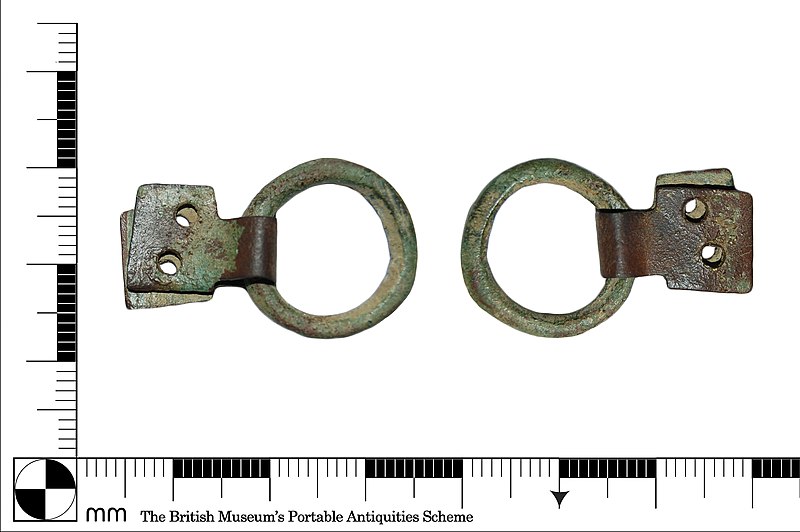
English: A complete cast copper-alloy buckle frame and folded plate dating to the Medieval period (AD 1300-1500).
The circular frame is D-shape in cross-section and has a bevelled edge on the reverse. The patination on the upper and lower surfaces is mottled light-green and brown in colour. Attached to the circular frame is a double-layered plate consisting of two flat square-shaped strips attached to the circular frame by a bent rectangular tab. Both strips are perforated by two adjacent circular holes. The plate has mid-brown patination with patches of light green in some areas. The circular frame is 19mm in diameter, 2.9mm wide and 2mm thick. The attached plate is 16.2mm long, 12mm wide and a combined 1.5mm thick. The holes are all 1.8mm diameter. The entire object weighs 2.63 grams. |
||
| Depicted place | (County of findspot) Hertfordshire | ||
| Date | between 1300 and 1500 | ||
| Accession number |
FindIdentifier: 1010474 |
||
| Credit line |
|
||
| Source |
https://finds.org.uk/database/ajax/download/id/1118581 Catalog: https://finds.org.uk/database/images/image/id/1118581/recordtype/artefacts archive copy at the Wayback Machine Artefact: https://finds.org.uk/database/artefacts/record/id/1010474 |
||
| Permission (Reusing this file) |
Attribution License version 2.0 (verified 13 November 2020) | ||
| Object location | | View this and other nearby images on: OpenStreetMap |
|---|
.jpg¶ms=051.930000_N_-000.378916_E_globe:Earth_class:object_type:object__&language=en)
Licensing
[edit].jpg&action=edit§ion=2)
- You are free:
- to share – to copy, distribute and transmit the work
- to remix – to adapt the work
- Under the following conditions:
- attribution – You must give appropriate credit, provide a link to the license, and indicate if changes were made. You may do so in any reasonable manner, but not in any way that suggests the licensor endorses you or your use.
File history
Click on a date/time to view the file as it appeared at that time.
| Date/Time | Thumbnail | Dimensions | User | Comment | |
|---|---|---|---|---|---|
| current | 04:02, 12 November 2020 | | 2,953 × 1,963 (540 KB) | Fæ (talk | contribs) | Portable Antiquities Scheme, BH, FindID: 1010474-1118581, medieval, page 125, batch count 1909 |
You cannot overwrite this file.
File usage on Commons
The following page uses this file:
.jpg)
.jpg&oldid=705819733)