File:Medieval Mount (illustration by Jason Gibbons) (FindID 535978).jpg
Jump to navigation
Jump to search

Size of this preview: 800 × 585 pixels. Other resolutions: 320 × 234 pixels | 640 × 468 pixels | 1,024 × 748 pixels | 1,280 × 935 pixels | 2,560 × 1,871 pixels | 3,172 × 2,318 pixels.
Original file (3,172 × 2,318 pixels, file size: 1.37 MB, MIME type: image/jpeg)
Captions
Captions
Add a one-line explanation of what this file represents
Summary
[edit]| Medieval Mount (illustration by Jason Gibbons) | |||
|---|---|---|---|
| Photographer |
Norfolk County Council, Mary Chester-Kadwell, 2013-01-24 15:12:53 |
||
| Title |
Medieval Mount (illustration by Jason Gibbons) |
||
| Description |
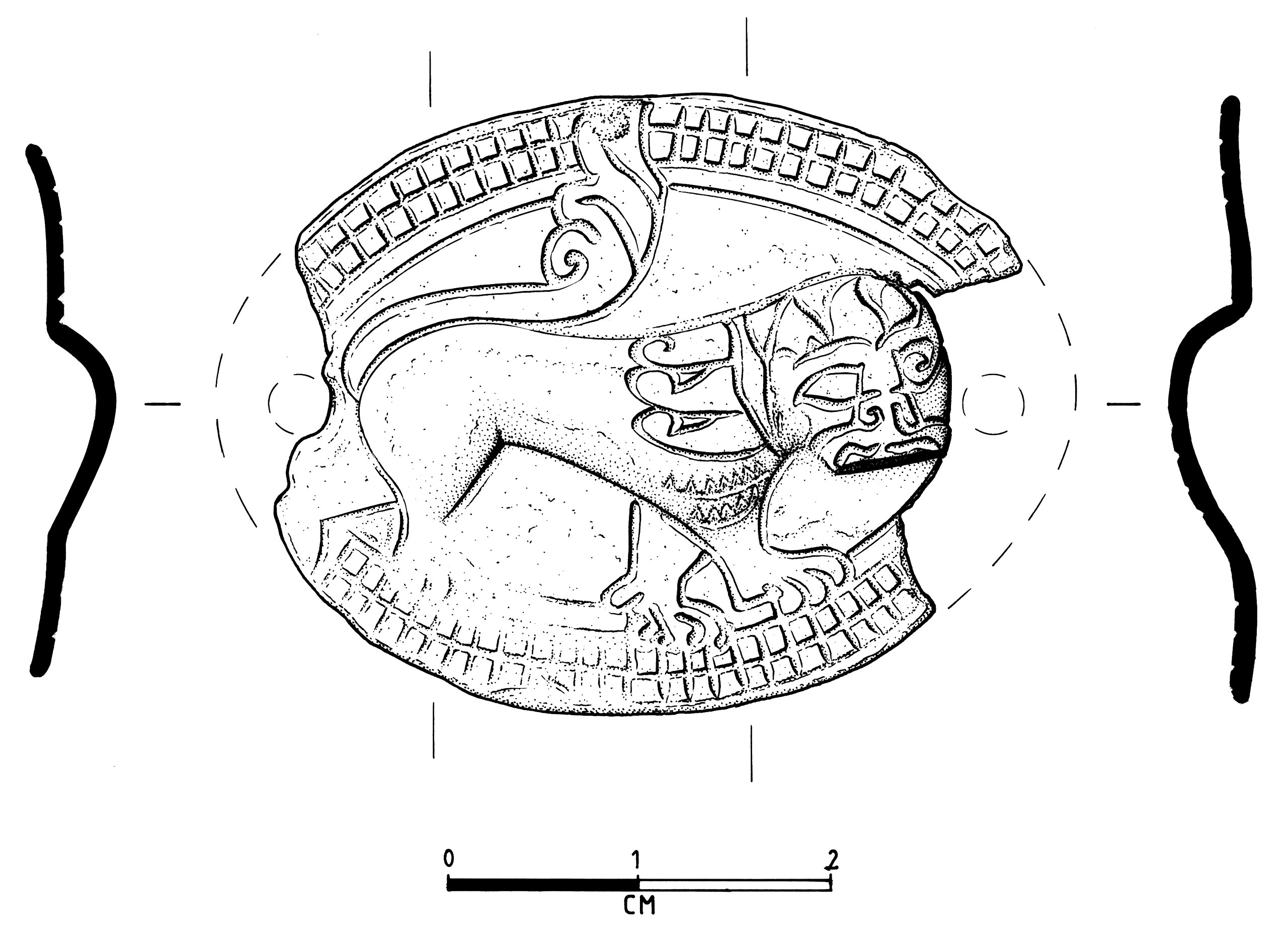
English: Medieval gilt copper alloy mount, oval, both ends missing, one break across one (of originally two) attachment holes. Within an engraved line of ladder-pattern border of three parallel lines with multiple transverse lines there is depicted a lion passant guardant to sinister. The head, body and legs are shown in low repoussé relief with details of the mane and facial features engraved. The tail and the paws are similarly engraved onto the flat surrounds. Gilding is confined to the front face. Length (estimated) 42mm. Width 32mm. Thickness 1mm, through the lion 3mm. 12th century. |
||
| Depicted place | (County of findspot) Norfolk | ||
| Date | between 1100 and 1200 | ||
| Accession number |
FindID: 535978 Old ref: NMS-F2F161 Filename: 28868_F2F161_MED_Mount_ILL.jpg |
||
| Credit line |
|
||
| Source |
https://finds.org.uk/database/ajax/download/id/413273 Catalog: https://finds.org.uk/database/images/image/id/413273/recordtype/artefacts archive copy at the Wayback Machine Artefact: https://finds.org.uk/database/artefacts/record/id/535978 |
||
| Permission (Reusing this file) |
Attribution-ShareAlike License version 4.0 (verified 26 November 2020) | ||
| Other versions |
|
||
.jpg)
_(FindID_535978).jpg&action=edit§ion=1)
| Object location | | View this and other nearby images on: OpenStreetMap |
|---|
_(FindID_535978).jpg¶ms=052.546800_N_0001.173680_E_globe:Earth_class:object_type:object__&language=en)
Licensing
[edit]_(FindID_535978).jpg&action=edit§ion=2)
This file is licensed under the Creative Commons Attribution-Share Alike 4.0 International license.
Attribution: The Portable Antiquities Scheme/ The Trustees of the British Museum
- You are free:
- to share – to copy, distribute and transmit the work
- to remix – to adapt the work
- Under the following conditions:
- attribution – You must give appropriate credit, provide a link to the license, and indicate if changes were made. You may do so in any reasonable manner, but not in any way that suggests the licensor endorses you or your use.
- share alike – If you remix, transform, or build upon the material, you must distribute your contributions under the same or compatible license as the original.
File history
Click on a date/time to view the file as it appeared at that time.
| Date/Time | Thumbnail | Dimensions | User | Comment | |
|---|---|---|---|---|---|
| current | 09:08, 31 January 2017 | | 3,172 × 2,318 (1.37 MB) | Fæ (talk | contribs) | Portable Antiquities Scheme, NMS, FindID: 535978, medieval, page 4273, batch count 51 |
You cannot overwrite this file.
File usage on Commons
The following 2 pages use this file:
_(FindID_535978).jpg)
_(FindID_535978).jpg&oldid=814266906)