File:Medieval D shaped Buckle (FindID 453627).jpg
Jump to navigation
Jump to search

Size of this preview: 800 × 478 pixels. Other resolutions: 320 × 191 pixels | 640 × 383 pixels | 1,024 × 612 pixels | 1,592 × 952 pixels.
Original file (1,592 × 952 pixels, file size: 378 KB, MIME type: image/jpeg)
Captions
Captions
Add a one-line explanation of what this file represents
Summary
[edit].jpg&action=edit§ion=1)
| Medieval D shaped Buckle | |||
|---|---|---|---|
| Photographer |
West Yorkshire Archaeology Advisory Service, Mary Blevins, 2011-07-13 11:27:49 |
||
| Title |
Medieval D shaped Buckle |
||
| Description |
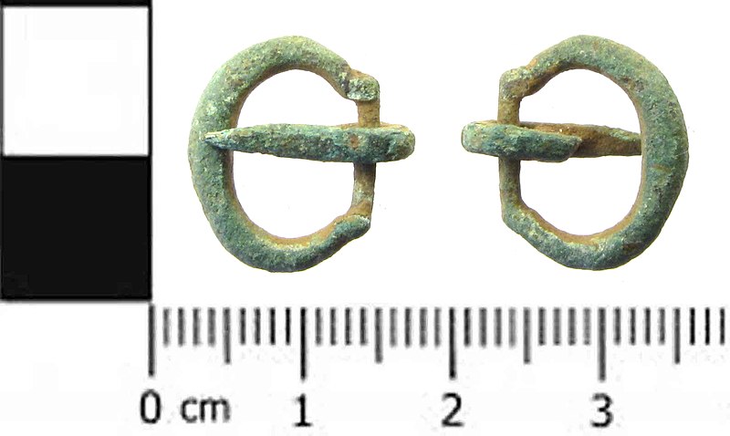
English: A cast copper-alloy single looped D-shaped buckle with a narrowed and offset strap bar, dating from the medieval period. It is a Meols type 2 buckle dating from 1250-1450. The pin is still attached and moves freely. It is a thick strip of copper alloy; undecorated and tapering to a pint with a rough loop round the bar. The plate is missing. The buckle is undecorated and has a light green patina. The single looped D-shaped buckle was one of the most common types during the 13th and 14th centuries but were gradually replaced by double looped buckles from the 15th century. Length: 12.30mm; Width: 15.60mm; Thickness: 4.62mm; Weight: 0.94g.
See Meols page 84. |
||
| Depicted place | (County of findspot) East Riding of Yorkshire | ||
| Date | between 1250 and 1450 | ||
| Accession number |
FindID: 453627 Old ref: SWYOR-D6ABB8 Filename: PAS_1436_buckle.jpg |
||
| Credit line |
|
||
| Source |
https://finds.org.uk/database/ajax/download/id/337543 Catalog: https://finds.org.uk/database/images/image/id/337543/recordtype/artefacts archive copy at the Wayback Machine Artefact: https://finds.org.uk/database/artefacts/record/id/453627 |
||
| Permission (Reusing this file) |
Attribution-ShareAlike License version 4.0 (verified 22 November 2020) | ||
| Object location | | View this and other nearby images on: OpenStreetMap |
|---|
.jpg¶ms=053.774800_N_-000.655588_E_globe:Earth_class:object_type:object__&language=en)
Licensing
[edit].jpg&action=edit§ion=2)
This file is licensed under the Creative Commons Attribution-Share Alike 4.0 International license.
Attribution: The Portable Antiquities Scheme/ The Trustees of the British Museum
- You are free:
- to share – to copy, distribute and transmit the work
- to remix – to adapt the work
- Under the following conditions:
- attribution – You must give appropriate credit, provide a link to the license, and indicate if changes were made. You may do so in any reasonable manner, but not in any way that suggests the licensor endorses you or your use.
- share alike – If you remix, transform, or build upon the material, you must distribute your contributions under the same or compatible license as the original.
File history
Click on a date/time to view the file as it appeared at that time.
| Date/Time | Thumbnail | Dimensions | User | Comment | |
|---|---|---|---|---|---|
| current | 23:40, 4 February 2017 | | 1,592 × 952 (378 KB) | Fæ (talk | contribs) | Portable Antiquities Scheme, SWYOR, FindID: 453627, medieval, page 7950, batch primary count 63501 |
You cannot overwrite this file.
File usage on Commons
The following page uses this file:
.jpg)
.jpg&oldid=814197813)