File:Mecklenburg-Vorpommern Gewässer.png
Jump to navigation
Jump to search

Size of this preview: 787 × 600 pixels. Other resolutions: 315 × 240 pixels | 630 × 480 pixels | 1,008 × 768 pixels | 1,280 × 975 pixels | 1,562 × 1,190 pixels.
Original file (1,562 × 1,190 pixels, file size: 117 KB, MIME type: image/png)
Captions
Captions
Add a one-line explanation of what this file represents
Summary
[edit]
| Description |
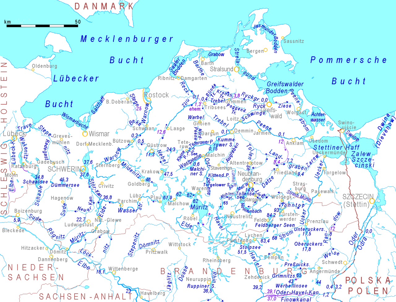
English: Map of Mecklenburg-Western Pomerania: waterbodies
dark blue figures = water level above sea level in meters dark blue arrows = direction of water flow lilac = water bodies crossing divides Deutsch: Gewässerkarte von Mecklenburg-Vorpommern: dunkelblaue Zahlen = Wasserspiegel über HN dunkelblaue Pfeile = Strömungsrichtung lila = Gewässer kreuzt Wasserscheide. |
| Source | http://www.maps-for-free.html |
| Author | Ulamm 00:30, 11 February 2008 (UTC) |
| Other versions |
|
Licensing
[edit]
This file is licensed under the Creative Commons Attribution-Share Alike 3.0 Unported license.
- You are free:
- to share – to copy, distribute and transmit the work
- to remix – to adapt the work
- Under the following conditions:
- attribution – You must give appropriate credit, provide a link to the license, and indicate if changes were made. You may do so in any reasonable manner, but not in any way that suggests the licensor endorses you or your use.
- share alike – If you remix, transform, or build upon the material, you must distribute your contributions under the same or compatible license as the original.
File history
Click on a date/time to view the file as it appeared at that time.
| Date/Time | Thumbnail | Dimensions | User | Comment | |
|---|---|---|---|---|---|
| current | 10:21, 8 April 2019 | | 1,562 × 1,190 (117 KB) | Ulamm (talk | contribs) | Nordpeene, Malliner Wasser |
| 19:59, 18 May 2016 |  | 1,562 × 1,190 (115 KB) | Ulamm (talk | contribs) | Dwina (Diewenow) | |
| 17:27, 15 May 2016 |  | 1,562 × 1,190 (115 KB) | Ulamm (talk | contribs) | some names, some layout | |
| 14:30, 13 May 2016 |  | 1,562 × 1,190 (113 KB) | Ulamm (talk | contribs) | 0.2 m | |
| 14:11, 13 May 2016 |  | 1,562 × 1,190 (113 KB) | Ulamm (talk | contribs) | once more | |
| 13:54, 13 May 2016 |  | 1,562 × 1,190 (113 KB) | Ulamm (talk | contribs) | Sources of river Peene completed | |
| 23:21, 10 May 2016 |  | 1,562 × 1,190 (111 KB) | Ulamm (talk | contribs) | one date, one layout | |
| 14:16, 10 May 2016 |  | 1,562 × 1,190 (111 KB) | Ulamm (talk | contribs) | once more | |
| 14:04, 10 May 2016 |  | 1,562 × 1,190 (111 KB) | Ulamm (talk | contribs) | some more courses of water | |
| 12:02, 25 November 2013 |  | 1,562 × 1,190 (109 KB) | Ulamm (talk | contribs) | Ergänzungen |
You cannot overwrite this file.
File usage on Commons
The following page uses this file:
File usage on other wikis
The following other wikis use this file:
- Usage on de.wikipedia.org