File:Mcmurray oli 2016126 swir lrg.jpg
Jump to navigation
Jump to search

Size of this preview: 800 × 600 pixels. Other resolutions: 320 × 240 pixels | 640 × 480 pixels | 1,024 × 768 pixels | 1,280 × 960 pixels | 2,560 × 1,920 pixels | 4,000 × 3,000 pixels.
Original file (4,000 × 3,000 pixels, file size: 5.88 MB, MIME type: image/jpeg)
Captions
Captions
Add a one-line explanation of what this file represents
Summary
[edit]
| Description |
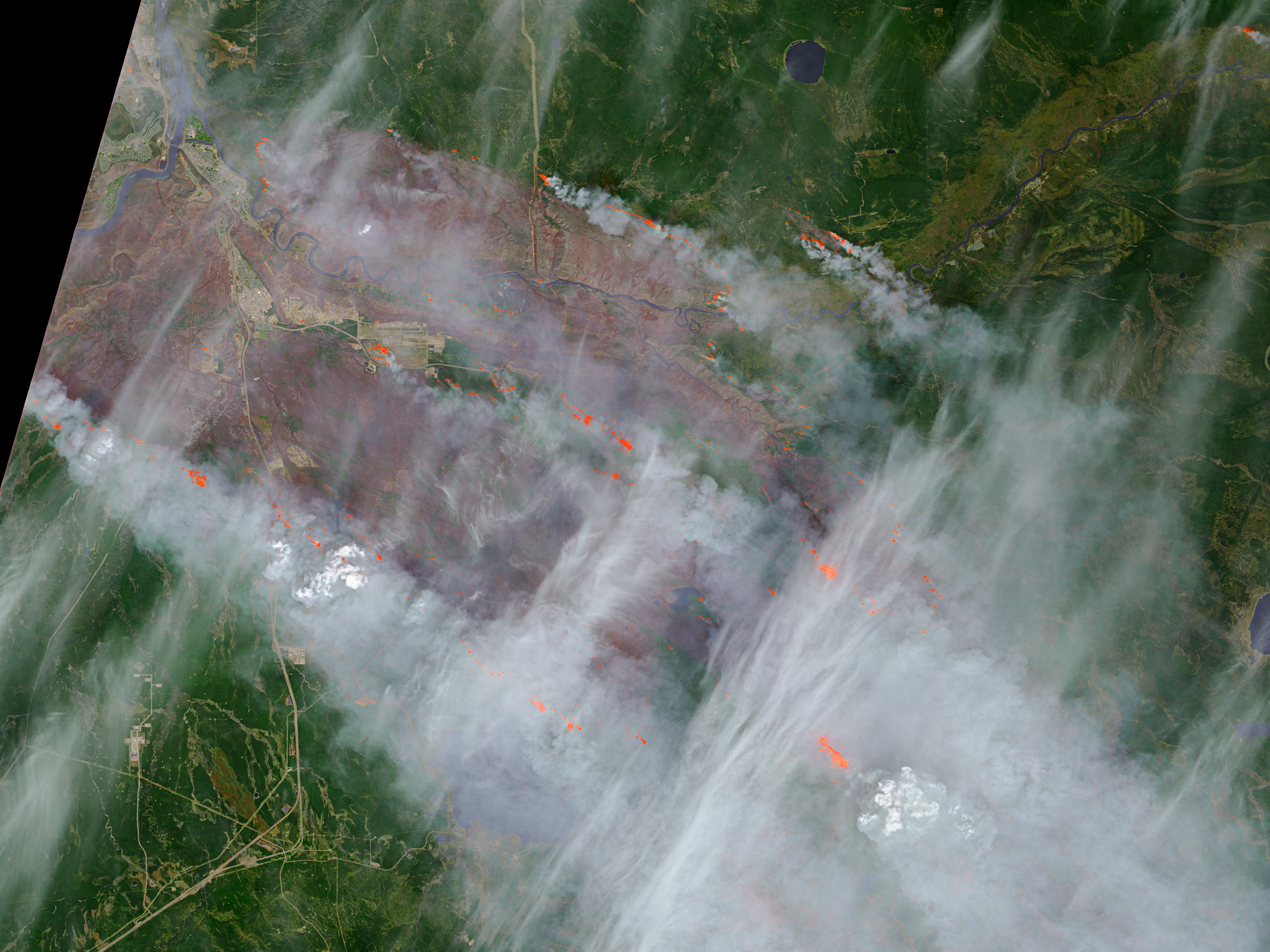
English: On May 5, 2016, the Operational Land Imager (OLI) on the Landsat 8 satellite acquired this false-color image of the wildfire that burned through Fort McMurray in Alberta, Canada. The image combines shortwave infrared, near infrared, and green light (OLI bands 7-5-3). Near- and short-wave infrared help penetrate clouds and smoke to reveal the hot spots associated with active fires, which appear red. Smoke appears white and burned areas appear brown.
According to news reports, the burned area grew significantly overnight. On the evening of May 4, the burned area spanned about 100 square kilometers (40 square miles); by the morning of May 5, it spanned about 850 square kilometers (330 square miles). |
| Date | |
| Source | http://eoimages.gsfc.nasa.gov/images/imagerecords/87000/87990/mcmurray_oli_2016126_swir_lrg.jpg OLI on Landsat 8 |
| Author | Landsat 8/NASA |
Licensing
[edit]
| This file is in the public domain in the United States because it was solely created by NASA. NASA copyright policy states that "NASA material is not protected by copyright unless noted". (See Template:PD-USGov, NASA copyright policy page or JPL Image Use Policy.) | ||
 |
Warnings:
|
File history
Click on a date/time to view the file as it appeared at that time.
| Date/Time | Thumbnail | Dimensions | User | Comment | |
|---|---|---|---|---|---|
| current | 01:02, 7 May 2016 | | 4,000 × 3,000 (5.88 MB) | Oaktree b (talk | contribs) | User created page with UploadWizard |
You cannot overwrite this file.
File usage on Commons
There are no pages that use this file.