File:Maysak 2015-04-01 0425Z.png
Jump to navigation
Jump to search

Size of this preview: 800 × 450 pixels. Other resolutions: 320 × 180 pixels | 640 × 360 pixels | 1,024 × 576 pixels | 1,280 × 720 pixels | 2,048 × 1,152 pixels.
Original file (2,048 × 1,152 pixels, file size: 3.43 MB, MIME type: image/png)
Captions
Captions
Add a one-line explanation of what this file represents
Summary
[edit]
| Description |
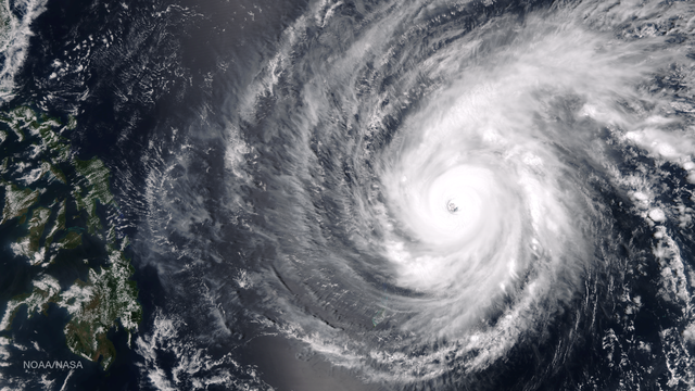
English: Typhoon Maysak is tracking west-northwestward through the western Pacific Ocean, northwest of Yap Island. The storm has maintained its 15 nautical mile diameter eye, but is weakening slightly as dry air encroaches from the southern periphery. Regardless, the storm is in a favorable environment with moderate vertical wind shear and robust pole-ward outflow for now. Maysak will begin soon to slowly weaken as vertical wind shear increases and will continue to decay as the system makes landfall in the northern Philippines around 72 hours. Because the system will impact Luzon as a significant typhoon, Maysak is expected to re-emerge in the South China Sea at typhoon strength. This image was taken by the Suomi NPP satellite's VIIRS instrument around 0425Z on April 1, 2015. |
| Date | |
| Source | https://www.nnvl.noaa.gov/MediaDetail2.php?MediaID=1687&MediaTypeID=1 |
| Author | NASA |
Licensing
[edit]
| This file is in the public domain in the United States because it was solely created by NASA. NASA copyright policy states that "NASA material is not protected by copyright unless noted". (See Template:PD-USGov, NASA copyright policy page or JPL Image Use Policy.) | ||
 |
Warnings:
|
File history
Click on a date/time to view the file as it appeared at that time.
| Date/Time | Thumbnail | Dimensions | User | Comment | |
|---|---|---|---|---|---|
| current | 08:26, 3 April 2018 | | 2,048 × 1,152 (3.43 MB) | A1Cafel (talk | contribs) | User created page with UploadWizard |
You cannot overwrite this file.
File usage on Commons
There are no pages that use this file.