File:Mayon Volcano Erupts in the Philippines (NESDIS 2018-01-29).jpg
Jump to navigation
Jump to search
Size of this preview: 800 × 450 pixels. Other resolutions: 320 × 180 pixels | 640 × 360 pixels | 1,024 × 576 pixels | 1,280 × 720 pixels | 1,920 × 1,080 pixels.
Original file (1,920 × 1,080 pixels, file size: 276 KB, MIME type: image/jpeg)
Captions
Captions
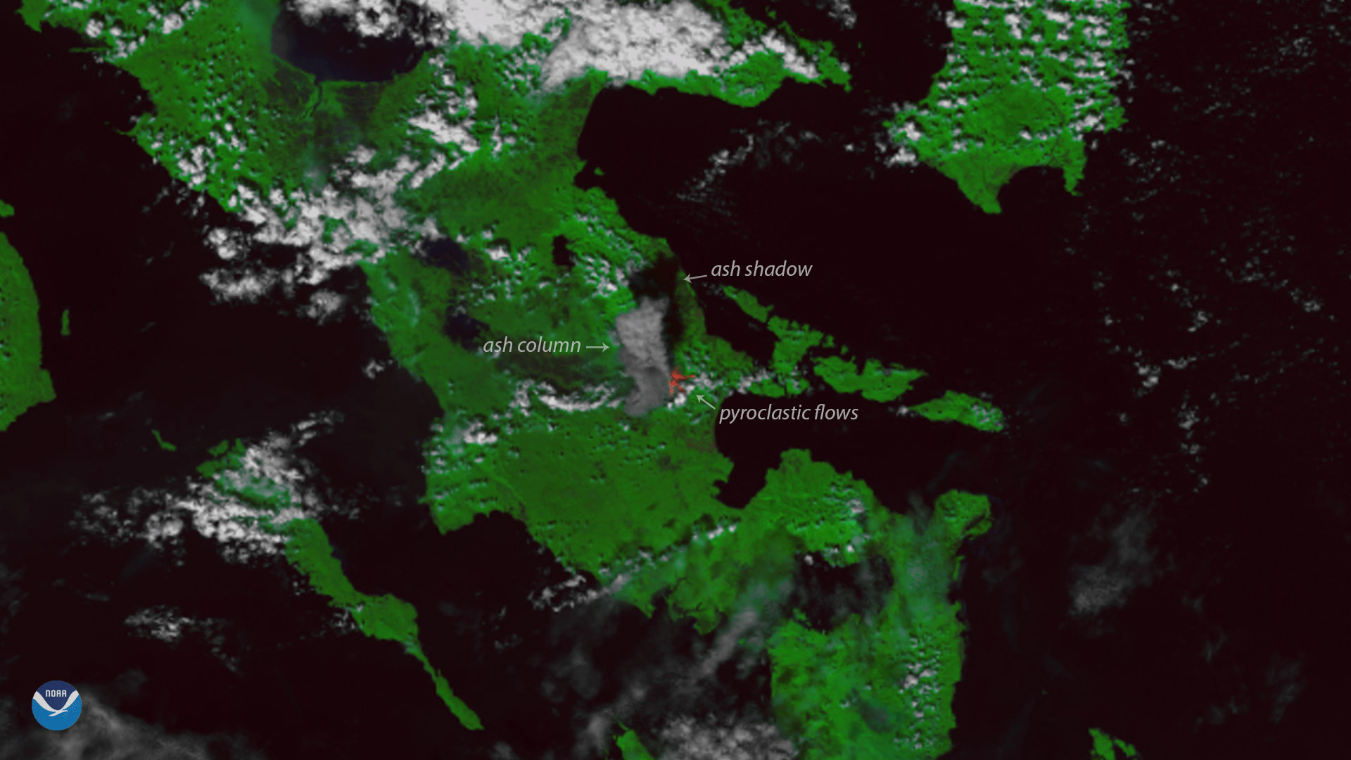
The Suomi NPP satellite's VIIRS instrument captured this image of the Mayon Volcano in the Philippines on January 22, 2018.
Summary
[edit].jpg&action=edit§ion=1)
| Description |
English: The Suomi NPP satellite's VIIRS instrument captured this image of the Mayon Volcano in the Philippines on January 22, 2018. Located in Albay Province, on the island of Luzon, the stratovolcano began erupting earlier this month, sending a tall column of ash into the sky over the past week. The volcanic activity has led local authorities to declare a five-mile danger zone in the vicinity of the eruption, and has forced more than 80,000 people in nearby villages to evacuate, according to media reports. A "level 4" alert was issued last week, after the volcano began spewing lava and generating an ash cloud more than three miles high. Mount Mayon is the most active volcano in the Philippines. Rising more than 8,000 feet from the nearby sea, the volcano has erupted more than 50 times in the past 500 years. This image was created by combining three of the high resolution thermal and visible channels from the Suomi NPP satellite's VIIRS sensor (SVI 4,2,1 RGB). These channels allow us to distinguish different land types and features based on their visual and thermal differences. In this imagery, the thick ash cloud and its shadow appear gray in the center of the image. Hotter areas, such as the location of pyroclastic flows - where hot ash and lava fragments are flowing down the mountain slopes - appear red in the imagery. |
| Date | 29 January 2018 (upload date) |
| Source | Mayon Volcano Erupts in the Philippines |
| Author | NOAA |
Licensing
[edit].jpg&action=edit§ion=2)
This image is in the public domain because it contains materials that originally came from the U.S. National Oceanic and Atmospheric Administration, taken or made as part of an employee's official duties.
|
File history
Click on a date/time to view the file as it appeared at that time.
| Date/Time | Thumbnail | Dimensions | User | Comment | |
|---|---|---|---|---|---|
| current | 21:17, 2 June 2024 | | 1,920 × 1,080 (276 KB) | OptimusPrimeBot (talk | contribs) | #Spacemedia - Upload of https://nesdis-prod.s3.amazonaws.com/2021-06/2183v1_20180122-mayonvolcano.jpeg via Commons:Spacemedia |
You cannot overwrite this file.
File usage on Commons
There are no pages that use this file.
.jpg&oldid=880937482)