File:Max Simon, Karte des alttestamentlichen Palaestina (FL165906225 2366886).jpg
Jump to navigation
Jump to search

Size of this preview: 800 × 534 pixels. Other resolutions: 320 × 214 pixels | 640 × 428 pixels | 1,024 × 684 pixels | 1,280 × 855 pixels | 2,560 × 1,710 pixels | 5,080 × 3,394 pixels.
Original file (5,080 × 3,394 pixels, file size: 14.03 MB, MIME type: image/jpeg)
Captions
Captions
Add a one-line explanation of what this file represents
Summary
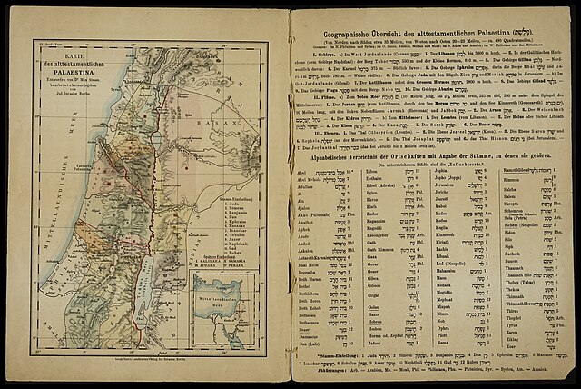
[edit]| Karte des alttestamentlichen Palaestina
|
|||||||||||||||||||||||||||||||||||||||||||
|---|---|---|---|---|---|---|---|---|---|---|---|---|---|---|---|---|---|---|---|---|---|---|---|---|---|---|---|---|---|---|---|---|---|---|---|---|---|---|---|---|---|---|---|
| Artist |
|
.jpg) | |||||||||||||||||||||||||||||||||||||||||
| Title |
Karte des alttestamentlichen Palaestina |
||||||||||||||||||||||||||||||||||||||||||
| Publisher | |||||||||||||||||||||||||||||||||||||||||||
| Object type |
topographic map |
||||||||||||||||||||||||||||||||||||||||||
| Genre |
map |
||||||||||||||||||||||||||||||||||||||||||
| Description |
Karte des alttestamentlichen Palaestina. Entworfen von Dr. Max Simon, bearbeitet u.herausgegeben von Jul.Straube. |
||||||||||||||||||||||||||||||||||||||||||
| Language |
German |
||||||||||||||||||||||||||||||||||||||||||
| Publication date |
1878 |
||||||||||||||||||||||||||||||||||||||||||
| Dimensions |
height: 226 mm (8.8 in) |
||||||||||||||||||||||||||||||||||||||||||
| Collection |
|
||||||||||||||||||||||||||||||||||||||||||
| Current location |
|
||||||||||||||||||||||||||||||||||||||||||
| Place of publication |
Berlin |
||||||||||||||||||||||||||||||||||||||||||
| Notes | Geograph. Institut; Incl. division among the 12 Tribes and later division of districts; Bottom right inset: Small map of eastern Mediterranean; On opposite page: Geographic notes on Palestine of the Old Testament and German-Hebrew alphabetical list of place names; Varies from first edition: Changes in index and modernized German spelling | ||||||||||||||||||||||||||||||||||||||||||
| IE PID | IE165906222 | ||||||||||||||||||||||||||||||||||||||||||
| Rosetta filename | FL165906225 | ||||||||||||||||||||||||||||||||||||||||||
| NNL item ID (P3959) | 990023668860205171 | ||||||||||||||||||||||||||||||||||||||||||
| search Merhav catalog | German, Max Simon, Berlin, Julius Straube, Geographisches Institut und Landkarten-Verlag Jul. Straube | ||||||||||||||||||||||||||||||||||||||||||
| search Merhav catalog | Landkarten-Verlag Jul. Straube | ||||||||||||||||||||||||||||||||||||||||||
| Source/Photographer |
|
||||||||||||||||||||||||||||||||||||||||||
| Other versions | |||||||||||||||||||||||||||||||||||||||||||
| Jpg / Tif version |
|
||||||||||||||||||||||||||||||||||||||||||


_(cropped).jpg)
_(cropped2).jpg)
_(cropped3).jpg)
_(cropped4).jpg)


.jpg&action=edit§ion=1)
Licensing
[edit].jpg&action=edit§ion=2)
The copyright situation of this work is theoretically uncertain, because in the country of origin copyright lasts 70 years after the death of the author, and the date of the author's death is unknown. However, the date of creation of the work was over 120 years ago, and it is thus a reasonable assumption that the copyright has expired (see here for the community discussion). Do not use this template if the date of death of the author is known.
| |
| This file has been identified as being free of known restrictions under copyright law, including all related and neighboring rights. | |
File history
Click on a date/time to view the file as it appeared at that time.
| Date/Time | Thumbnail | Dimensions | User | Comment | |
|---|---|---|---|---|---|
| current | 13:11, 25 July 2023 | | 5,080 × 3,394 (14.03 MB) | Geagea (talk | contribs) | pattypan 22.03 |
You cannot overwrite this file.
File usage on Commons
The following 7 pages use this file:
- File:Max Simon, Karte des alttestamentlichen Palaestina (FL165906225 2366886).jpg
- File:Max Simon, Karte des alttestamentlichen Palaestina (FL165906225 2366886).tif
- File:Max Simon, Karte des alttestamentlichen Palaestina (FL165906225 2366886) (cropped).jpg
- File:Max Simon, Karte des alttestamentlichen Palaestina (FL165906225 2366886) (cropped2).jpg
- File:Max Simon, Karte des alttestamentlichen Palaestina (FL165906225 2366886) (cropped3).jpg
- File:Max Simon, Karte des alttestamentlichen Palaestina (FL165906225 2366886) (cropped4).jpg
- Category:Max Simon, Karte des alttestamentlichen Palaestina
File usage on other wikis
The following other wikis use this file:
- Usage on he.wikipedia.org
- Usage on www.wikidata.org
.jpg&oldid=869436601)