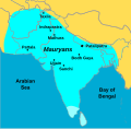
File:Mauryan Empire map.svg

Original file (SVG file, nominally 255 × 250 pixels, file size: 61 KB)
Captions
Captions
Summary
[edit]| DescriptionMauryan Empire map.svg |
English: A political map of the Mauryan Empire, including notable cities, such as the capital Pataliputra, and site of the Buddha's enlightenment. |
| Date | |
| Source | Atlas |
| Author | Vectorization: MaxxL |
| Other versions |
 |
| SVG development InfoField |
Licensing
[edit]
|
This map has been uploaded by Electionworld from en.wikipedia.org to enable the |
| Public domainPublic domainfalsefalse |
| This work has been released into the public domain by its author, Maxxl2. This applies worldwide. In some countries this may not be legally possible; if so: |
File history
Click on a date/time to view the file as it appeared at that time.
| Date/Time | Thumbnail | Dimensions | User | Comment | |
|---|---|---|---|---|---|
| current | 09:26, 30 September 2024 |  | 255 × 250 (61 KB) | Sbb1413 (talk | contribs) | Removed border of Tibet, used condensed font, added historical names with modern names in brackets. |
| 14:18, 18 April 2014 |  | 255 × 250 (50 KB) | MaxxL (talk | contribs) | improved limits | |
| 13:10, 18 April 2014 |  | 255 × 250 (73 KB) | MaxxL (talk | contribs) | Hmalaya borders adjusted | |
| 11:16, 18 April 2014 |  | 255 × 250 (48 KB) | MaxxL (talk | contribs) | == {{int:filedesc}} == {{Information |Description= A poltical map of the Mauryan Empire, including notable cities, such as the capital Pataliputra, and site of the Buddha's enlightenment. |Source= Atlas |Date= 2014-04-18 |Author= vectorized b... |
You cannot overwrite this file.
File usage on Commons
The following 6 pages use this file:
File usage on other wikis
The following other wikis use this file:
- Usage on de.wikipedia.org
- Usage on id.wikipedia.org
- Usage on www.wikidata.org
Metadata
This file contains additional information such as Exif metadata which may have been added by the digital camera, scanner, or software program used to create or digitize it. If the file has been modified from its original state, some details such as the timestamp may not fully reflect those of the original file. The timestamp is only as accurate as the clock in the camera, and it may be completely wrong.
| Width | 255 |
|---|---|
| Height | 250 |