File:Mauritania-Brakna.png
Jump to navigation
Jump to search
No higher resolution available.
Mauritania-Brakna.png (150 × 167 pixels, file size: 3 KB, MIME type: image/png)
Captions
Captions
Add a one-line explanation of what this file represents
| Description |
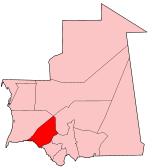
Map of Mauritania showing Brakna region. Deutsch: Lage der Verwaltungregion Brakna in Mauretanien |
| Date | |
| Source | Self-made, traced from public domain UN or CIA maps. |
| Author | User:Golbez |
| Permission (Reusing this file) |
Provide attribution, please. See below. |
| Other versions | See Image:Mauritania regions numbered.png for the numbered map of the regions. |
I, the copyright holder of this work, hereby publish it under the following licenses:
This file is licensed under the Creative Commons Attribution-Share Alike 2.5 Generic, 2.0 Generic and 1.0 Generic license.
- You are free:
- to share – to copy, distribute and transmit the work
- to remix – to adapt the work
- Under the following conditions:
- attribution – You must give appropriate credit, provide a link to the license, and indicate if changes were made. You may do so in any reasonable manner, but not in any way that suggests the licensor endorses you or your use.
- share alike – If you remix, transform, or build upon the material, you must distribute your contributions under the same or compatible license as the original.

|
Permission is granted to copy, distribute and/or modify this document under the terms of the GNU Free Documentation License, Version 1.2 or any later version published by the Free Software Foundation; with no Invariant Sections, no Front-Cover Texts, and no Back-Cover Texts. A copy of the license is included in the section entitled GNU Free Documentation License. |
| This file is licensed under the Creative Commons Attribution-Share Alike 3.0 Unported license. | ||
| ||
| This licensing tag was added to this file as part of the GFDL licensing update. |
You may select the license of your choice.
File history
Click on a date/time to view the file as it appeared at that time.
| Date/Time | Thumbnail | Dimensions | User | Comment | |
|---|---|---|---|---|---|
| current | 04:51, 20 February 2005 | | 150 × 167 (3 KB) | Golbez (talk | contribs) | Map of Mauritania showing Brakna region. Made by User:Golbez. {{cc-by-sa-2.0}} |
You cannot overwrite this file.
File usage on Commons
There are no pages that use this file.
File usage on other wikis
The following other wikis use this file:
- Usage on ar.wikipedia.org
- ولاية البراكنة
- بوبكر بن عامر
- تجكجة
- تيشيت
- ألاك
- قالب:ولاية البراكنة
- مقاطعة مقطع الحجار
- مقطع الحجار
- دلوار
- الرشيد (مدينة موريتانية)
- تمبارة
- المجرية (موريتانيا)
- صنكرافة
- الحصيرة
- مال (موريتانيا)
- السدود (موريتانيا)
- مقاطعة بوكي
- مقاطعة أمباني
- مقاطعة ألاك
- مقاطعة بابابي
- قالب:ولاية تكانت
- مقاطعة تيشيت
- مقاطعة المجرية
- مقاطعة تجكجة
- نيابينا
- Usage on be.wikipedia.org
- Usage on da.wikipedia.org
- Usage on fr.wikinews.org
- Usage on ms.wikipedia.org
- Usage on nl.wikipedia.org
- Usage on pt.wikipedia.org
- Usage on ro.wikipedia.org
- Usage on zh.wikipedia.org