File:Matthew Paris, Matthew Paris map of Palestine - ZDPV printed version of inscriptions. Geograph. Anstalt von Wagner & Debes Leipzig (FL169642148 0898357).jpg
Jump to navigation
Jump to search

Size of this preview: 800 × 569 pixels. Other resolutions: 320 × 228 pixels | 640 × 455 pixels | 1,024 × 729 pixels | 1,280 × 911 pixels | 2,560 × 1,821 pixels | 10,050 × 7,150 pixels.
Original file (10,050 × 7,150 pixels, file size: 57.61 MB, MIME type: image/jpeg)
Captions
Captions
Add a one-line explanation of what this file represents
Summary
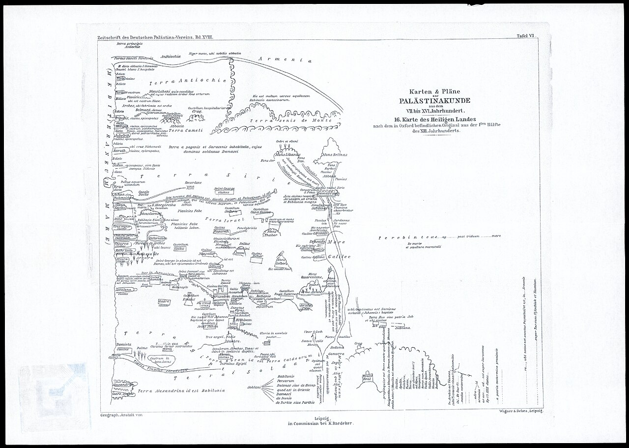
[edit]| Matthew Paris: Matthew Paris map of Palestine - ZDPV printed version of inscriptions. Geograph. Anstalt von Wagner & Debes Leipzig
( |
||||||||||||||||||||||||
|---|---|---|---|---|---|---|---|---|---|---|---|---|---|---|---|---|---|---|---|---|---|---|---|---|
| Artist |
|
|||||||||||||||||||||||
| Title |
Matthew Paris map of Palestine - ZDPV printed version of inscriptions. Geograph. Anstalt von Wagner & Debes Leipzig |
|||||||||||||||||||||||
| Publisher |
K. Baedeker |
|||||||||||||||||||||||
| Description |
Matthew Paris map of Palestine - ZDPV printed version of inscriptions. Geograph. Anstalt von Wagner & Debes Leipzig.. |
|||||||||||||||||||||||
| Language | Latin, German | |||||||||||||||||||||||
| Publication date | 1895 | |||||||||||||||||||||||
| Medium | 1 sheet ; | |||||||||||||||||||||||
| Dimensions | 27 × 32 cm (10.6 × 12.5 in) | |||||||||||||||||||||||
| Collection |
|
|||||||||||||||||||||||
| Current location |
|
|||||||||||||||||||||||
| Place of publication | Leipzig | |||||||||||||||||||||||
| search Merhav catalog | Leipzig | |||||||||||||||||||||||
| Notes | Photocopy of a map from Zeitschrift des Deutschen Palaestina Vereins, Bd. XVIII, 1895. Tafel VI. [PB 624]; Printed inscriptions version of map Pal 1565. | |||||||||||||||||||||||
| IE PID | IE169642146 | |||||||||||||||||||||||
| Rosetta filename | FL169642148 | |||||||||||||||||||||||
| NNL item ID (P3959) | 997008983577205171 | |||||||||||||||||||||||
| search Merhav catalog | Latin, German, Matthew Paris | |||||||||||||||||||||||
| search Merhav catalog | PalästinakundeK. Baedeker | |||||||||||||||||||||||
| Source/Photographer |
|
|||||||||||||||||||||||
| Other versions | ||||||||||||||||||||||||
| Jpg / Tif version |
|
|||||||||||||||||||||||


.jpg)

.jpg&action=edit§ion=1)
Licensing
[edit].jpg&action=edit§ion=2)
The copyright situation of this work is theoretically uncertain, because in the country of origin copyright lasts 70 years after the death of the author, and the date of the author's death is unknown. However, the date of creation of the work was over 120 years ago, and it is thus a reasonable assumption that the copyright has expired (see here for the community discussion). Do not use this template if the date of death of the author is known.
| |
| This file has been identified as being free of known restrictions under copyright law, including all related and neighboring rights. | |
File history
Click on a date/time to view the file as it appeared at that time.
| Date/Time | Thumbnail | Dimensions | User | Comment | |
|---|---|---|---|---|---|
| current | 13:07, 11 August 2023 | | 10,050 × 7,150 (57.61 MB) | Geagea (talk | contribs) | pattypan 22.03 |
You cannot overwrite this file.
File usage on Commons
The following page uses this file:
.jpg&oldid=847352979)