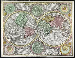
File:Matthäus Seuttetre, Diversi globi terr-aqvei statione variante et visu intercedente per coluros tropicorum, per ambos polos et particul (FL10521695 2725318) (cropped4).jpg

Original file (830 × 447 pixels, file size: 506 KB, MIME type: image/jpeg)
Captions
Captions
Summary
[edit]| Diversi globi terr-aqvei statione variante et visu intercedente per coluros tropicorum, per ambos polos et particul
|
|||||||||||||||||||||||||||||||||||||||||||||||||||||
|---|---|---|---|---|---|---|---|---|---|---|---|---|---|---|---|---|---|---|---|---|---|---|---|---|---|---|---|---|---|---|---|---|---|---|---|---|---|---|---|---|---|---|---|---|---|---|---|---|---|---|---|---|---|
| Artist |
|
||||||||||||||||||||||||||||||||||||||||||||||||||||
| Title |
Diversi globi terr-aqvei statione variante et visu intercedente per coluros tropicorum, per ambos polos et particul |
||||||||||||||||||||||||||||||||||||||||||||||||||||
| Publisher | |||||||||||||||||||||||||||||||||||||||||||||||||||||
| Object type |
antique map / manuscript map / world map / double hemisphere world map / early world maps |
||||||||||||||||||||||||||||||||||||||||||||||||||||
| Genre |
map |
||||||||||||||||||||||||||||||||||||||||||||||||||||
| Description |
Diversi globi terr-aqvei statione variante et visu intercedente per coluros tropicorum, per ambos polos et particul. A. C. Seutter delin ; Andr. Silbereisen sculps. |
||||||||||||||||||||||||||||||||||||||||||||||||||||
| Language |
German |
||||||||||||||||||||||||||||||||||||||||||||||||||||
| Publication date |
circa |
||||||||||||||||||||||||||||||||||||||||||||||||||||
| Medium | 1 map : col ; | ||||||||||||||||||||||||||||||||||||||||||||||||||||
| Dimensions | 19 × 25 cm (7.4 × 9.8 in) | ||||||||||||||||||||||||||||||||||||||||||||||||||||
| Collection |
institution QS:P195,Q188915 |
||||||||||||||||||||||||||||||||||||||||||||||||||||
| Current location |
institution QS:P195,Q111677119 |
||||||||||||||||||||||||||||||||||||||||||||||||||||
| Place of publication |
Augsburg |
||||||||||||||||||||||||||||||||||||||||||||||||||||
| Notes | Around the map astronomical diagrams and celestial charts | ||||||||||||||||||||||||||||||||||||||||||||||||||||
| IE PID InfoField | IE10521693 | ||||||||||||||||||||||||||||||||||||||||||||||||||||
| Rosetta filename InfoField | FL10521695 | ||||||||||||||||||||||||||||||||||||||||||||||||||||
| NNL item ID (P3959) InfoField | 990027253180205171 | ||||||||||||||||||||||||||||||||||||||||||||||||||||
| References | |||||||||||||||||||||||||||||||||||||||||||||||||||||
| search Merhav catalog InfoField | World mapsTobias Conrad Lotter | ||||||||||||||||||||||||||||||||||||||||||||||||||||
| search Merhav catalog InfoField | Matthäus Seuttetre, Albrecht Carl Seutter, Andreas Silbereisen, Augsburg | ||||||||||||||||||||||||||||||||||||||||||||||||||||
| Source/Photographer |
|
||||||||||||||||||||||||||||||||||||||||||||||||||||
| Other versions |
|
||||||||||||||||||||||||||||||||||||||||||||||||||||

Licensing
[edit]| Public domainPublic domainfalsefalse |
The copyright situation of this work is theoretically uncertain, because in the country of origin copyright lasts 70 years after the death of the author, and the date of the author's death is unknown. However, the date of creation of the work was over 120 years ago, and it is thus a reasonable assumption that the copyright has expired (see here for the community discussion). Do not use this template if the date of death of the author is known.
Note that a few countries have copyright terms longer than 70 years: Mexico has 100 years, Jamaica has 95 years, Colombia has 80 years, and Guatemala and Samoa have 75 years. This image may not be in the public domain in these countries, which moreover do not implement the rule of the shorter term. Honduras has a general copyright term of 75 years, but it does implement the rule of the shorter term. Copyright may extend on works created by French who died for France in World War II (more information), Russians who served in the Eastern Front of World War II (known as the Great Patriotic War in Russia) and posthumously rehabilitated victims of Soviet repressions (more information). | |
| This file has been identified as being free of known restrictions under copyright law, including all related and neighboring rights. | |
https://creativecommons.org/publicdomain/mark/1.0/PDMCreative Commons Public Domain Mark 1.0falsefalse
File history
Click on a date/time to view the file as it appeared at that time.
| Date/Time | Thumbnail | Dimensions | User | Comment | |
|---|---|---|---|---|---|
| current | 21:54, 20 July 2023 |  | 830 × 447 (506 KB) | Geagea (talk | contribs) | File:Matthäus Seuttetre, Diversi globi terr-aqvei statione variante et visu intercedente per coluros tropicorum, per ambos polos et particul (FL10521695 2725318).jpg cropped 82 % horizontally, 88 % vertically using CropTool with precise mode. |
You cannot overwrite this file.
File usage on Commons
The following 2 pages use this file:
- File:Matthäus Seuttetre, Diversi globi terr-aqvei statione variante et visu intercedente per coluros tropicorum, per ambos polos et particul (FL10521695 2725318).jpg
- File:Matthäus Seuttetre, Diversi globi terr-aqvei statione variante et visu intercedente per coluros tropicorum, per ambos polos et particul (FL10521695 2725318) (cropped4).jpg
Metadata
This file contains additional information such as Exif metadata which may have been added by the digital camera, scanner, or software program used to create or digitize it. If the file has been modified from its original state, some details such as the timestamp may not fully reflect those of the original file. The timestamp is only as accurate as the clock in the camera, and it may be completely wrong.
| Author | Admin |
|---|---|
| Date and time of data generation | 10 November 2013 |
| IIM version | 4 |
Structured data
image/jpeg
- Information field template with formatting
- Files from the National Library of Israel
- Extracted images
- Artworks with SDC link missing
- Artworks with Wikidata item
- Artworks with Wikidata item missing medium
- PD-old missing SDC copyright status
- CC-PD-Mark
- PD Old (assumed)
- Eran Laor Cartographic Collection maps/2023 batch
- Uploaded with pattypan


