
File:Master Plot Plan for Tule Lake - DPLA - 1dbaec76c313d711bdf7e597a518a074.jpg

Size of this preview: 800 × 531 pixels. Other resolutions: 320 × 212 pixels | 640 × 425 pixels | 1,024 × 680 pixels | 1,280 × 850 pixels | 2,560 × 1,699 pixels | 3,150 × 2,091 pixels.
Original file (3,150 × 2,091 pixels, file size: 2.41 MB, MIME type: image/jpeg)
Captions
Captions
Add a one-line explanation of what this file represents
Summary
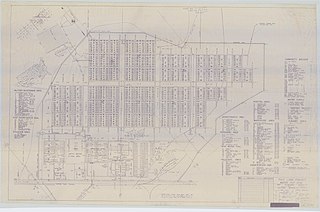
[edit]| Master Plot Plan for Tule Lake
( |
||||||||||||||
|---|---|---|---|---|---|---|---|---|---|---|---|---|---|---|
| Creator | Department of the Interior. War Relocation Authority. 2/16/1944-6/30/1946 | |||||||||||||
| Title |
Master Plot Plan for Tule Lake |
|||||||||||||
| Date | 1942-01-01/1945-12-31 | |||||||||||||
| Collection |
|
|||||||||||||
| Source/Photographer |
|
|||||||||||||
| Permission (Reusing this file) |
|
|||||||||||||
| Standardized rights statement |
|
|||||||||||||


File history
Click on a date/time to view the file as it appeared at that time.
| Date/Time | Thumbnail | Dimensions | User | Comment | |
|---|---|---|---|---|---|
| current | 20:40, 9 November 2022 | | 3,150 × 2,091 (2.41 MB) | DPLA bot (talk | contribs) | Uploading DPLA ID 1dbaec76c313d711bdf7e597a518a074 |
You cannot overwrite this file.
File usage on Commons
The following page uses this file:
File usage on other wikis
The following other wikis use this file:
- Usage on en.wikipedia.org