File:Maskat & Oman map.png
Jump to navigation
Jump to search

Size of this preview: 567 × 599 pixels. Other resolutions: 227 × 240 pixels | 454 × 480 pixels | 763 × 806 pixels.
Original file (763 × 806 pixels, file size: 21 KB, MIME type: image/png)
Captions
Captions
Add a one-line explanation of what this file represents

|
This map image could be re-created using vector graphics as an SVG file. This has several advantages; see Commons:Media for cleanup for more information. If an SVG form of this image is available, please upload it and afterwards replace this template with
{{vector version available|new image name}}.
It is recommended to name the SVG file “Maskat & Oman map.svg”—then the template Vector version available (or Vva) does not need the new image name parameter. |
| Description |
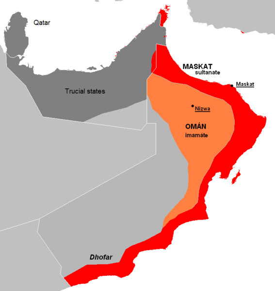
English: The approximate map of historic state of Mascat and Oman.
Čeština: Přibližná mapa historického státu Maskat a Omán |
| Date | (UTC) |
| Source | |
| Author |
|
| Other versions | العربيَّة |
| This is a retouched picture, which means that it has been digitally altered from its original version. Modifications: de facto new map, viz. description. The original can be viewed here: Al Hajar mountain woodlands map.png:
|
| I, the copyright holder of this work, release this work into the public domain. This applies worldwide. In some countries this may not be legally possible; if so: I grant anyone the right to use this work for any purpose, without any conditions, unless such conditions are required by law. |
Original upload log
[edit]
This image is a derivative work of the following images:
- File:AT1306_map.png licensed with PD-self
- 2008-02-27T09:16:44Z Doreano 763x806 (23794 Bytes) {{Information |Description=Gulf of Oman desert and semi-desert ecoregion map |Source=self-made |Date=2008/2/27 |Author= [[User:Altatoron|Altatoron]] |Permission= |other_versions= }} [[Category:Biomes]] [[Category:Biogeography
- File:AT0801_map.png licensed with PD-self
- 2008-02-27T09:10:47Z Doreano 676x806 (18852 Bytes) {{Information |Description=Al Hajar montane woodlands ecoregion map |Source=self-made |Date=2008/2/27 |Author= [[User:Altatoron|Altatoron]] |Permission= |other_versions= }} [[Category:Biomes]] [[Category:Biogeography]] [[Cate
Uploaded with derivativeFX
File history
Click on a date/time to view the file as it appeared at that time.
| Date/Time | Thumbnail | Dimensions | User | Comment | |
|---|---|---|---|---|---|
| current | 22:36, 7 July 2015 | | 763 × 806 (21 KB) | History of Persia (talk | contribs) | Made it easier to understand. |
| 19:06, 28 May 2010 |  | 763 × 806 (27 KB) | Kolomaznik (talk | contribs) | {{Information |Description={{en}}The approximate map of historic state of Mascat and Oman. {{cs}}Přibližná mapa historického státu Maskat a Omán |Source=*File:AT1306_map.png *File:AT0801_map.png |Date=2010-05-28 19:02 (UTC) |Author=*[[:F |
You cannot overwrite this file.
File usage on Commons
There are no pages that use this file.
File usage on other wikis
The following other wikis use this file:
- Usage on ar.wikipedia.org
- Usage on az.wikipedia.org
- Usage on cs.wikipedia.org
- Usage on de.wikipedia.org
- Usage on el.wikipedia.org
- Usage on en.wikipedia.org
- Usage on es.wikipedia.org
- Usage on eu.wikipedia.org
- Usage on fa.wikipedia.org
- Usage on fi.wikipedia.org
- Usage on fr.wikipedia.org
- Usage on he.wikipedia.org
- Usage on id.wikipedia.org
- Usage on it.wikipedia.org
- Usage on ko.wikipedia.org
- Usage on mn.wikipedia.org
- Usage on ms.wikipedia.org
- Usage on nl.wikipedia.org
- Usage on pl.wikipedia.org
- Usage on pt.wikipedia.org
- Usage on ru.wikipedia.org
- Usage on sl.wikipedia.org
- Usage on th.wikipedia.org
- Usage on tr.wikipedia.org
- Usage on uk.wikipedia.org
- Usage on vi.wikipedia.org
- Usage on www.wikidata.org
- Usage on zh.wikipedia.org