File:Maryland Presidential Election Results 2012.svg
Jump to navigation
Jump to search

Size of this PNG preview of this SVG file: 800 × 428 pixels. Other resolutions: 320 × 171 pixels | 640 × 342 pixels | 1,024 × 547 pixels | 1,280 × 684 pixels | 2,560 × 1,368 pixels | 810 × 433 pixels.
Original file (SVG file, nominally 810 × 433 pixels, file size: 41 KB)
Captions
Captions
Add a one-line explanation of what this file represents
Summary
[edit]
| Description |
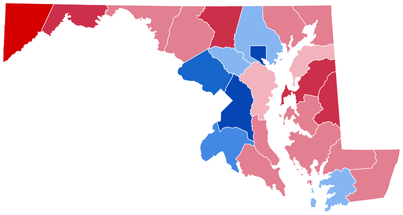
English: Results of the United States presidential election in Maryland, 2012
Obama—80-90%
Obama—70-80%
Obama—60-70%
Obama—50-60%
Romney—<50%
Romney—50-60%
Romney—60-70%
Romney—70-80% |
| Date | |
| Source | Own work |
| Author | Inqvisitor |
Licensing
[edit]
I, the copyright holder of this work, hereby publish it under the following license:
This file is licensed under the Creative Commons Attribution-Share Alike 3.0 Unported license.
- You are free:
- to share – to copy, distribute and transmit the work
- to remix – to adapt the work
- Under the following conditions:
- attribution – You must give appropriate credit, provide a link to the license, and indicate if changes were made. You may do so in any reasonable manner, but not in any way that suggests the licensor endorses you or your use.
- share alike – If you remix, transform, or build upon the material, you must distribute your contributions under the same or compatible license as the original.
File history
Click on a date/time to view the file as it appeared at that time.
| Date/Time | Thumbnail | Dimensions | User | Comment | |
|---|---|---|---|---|---|
| current | 17:40, 21 May 2024 | | 810 × 433 (41 KB) | GatewayPolitics (talk | contribs) | rv please do not change now that the majority of maps use the v2 style this also defeats the original purpose of having all us states maps being detailed but not too detailed to save on memory and have consistency with each other and have the same stroke width |
| 01:09, 1 May 2024 |  | 810 × 433 (98 KB) | LeonEpik (talk | contribs) | shapes | |
| 04:45, 22 June 2023 |  | 810 × 433 (41 KB) | Putitonamap98 (talk | contribs) | shapes | |
| 20:40, 20 January 2023 |  | 744 × 405 (222 KB) | Putitonamap98 (talk | contribs) | shapes | |
| 01:21, 14 December 2022 |  | 744 × 405 (222 KB) | AntiCompositeNumber (talk | contribs) | Reverted to version as of 21:15, 13 December 2022 (UTC) | |
| 00:45, 14 December 2022 |  | 224 × 120 (8 KB) | Denver606 (talk | contribs) | Reverted to version as of 13:50, 12 December 2022 (UTC) | |
| 21:15, 13 December 2022 |  | 744 × 405 (222 KB) | Elli (talk | contribs) | rv sock | |
| 17:06, 13 December 2022 |  | 224 × 120 (8 KB) | Icecream441 (talk | contribs) | Reverted to version as of 13:50, 12 December 2022 (UTC) | |
| 05:45, 13 December 2022 |  | 744 × 405 (222 KB) | Huntster (talk | contribs) | Reverted to version as of 23:31, 21 November 2022 (UTC) | |
| 13:50, 12 December 2022 |  | 224 × 120 (8 KB) | Sox589 (talk | contribs) | Reverted to version as of 21:28, 27 September 2020 (UTC) |
You cannot overwrite this file.
File usage on Commons
The following 8 pages use this file:
- User:Magog the Ogre/Political maps/2020 September 21-30
- User:Magog the Ogre/Political maps/2022 December 11-20
- User:Magog the Ogre/Political maps/2022 November 21-30
- User:Magog the Ogre/Political maps/2023 January 11-20
- User:Magog the Ogre/Political maps/2023 June 21-30
- User:Magog the Ogre/Political maps/2024 May 1-10
- User:Magog the Ogre/Political maps/2024 May 21-31
- File:Maryland presidential election results 2012.svg (file redirect)
File usage on other wikis
The following other wikis use this file:
- Usage on en.wikipedia.org
- Usage on ko.wikipedia.org