File:MarsCuriosityRover-WhimsicalRock-20210727.png

Original file (1,024 × 1,024 pixels, file size: 584 KB, MIME type: image/png)
Captions
Captions
Summary
[edit]
| Description |
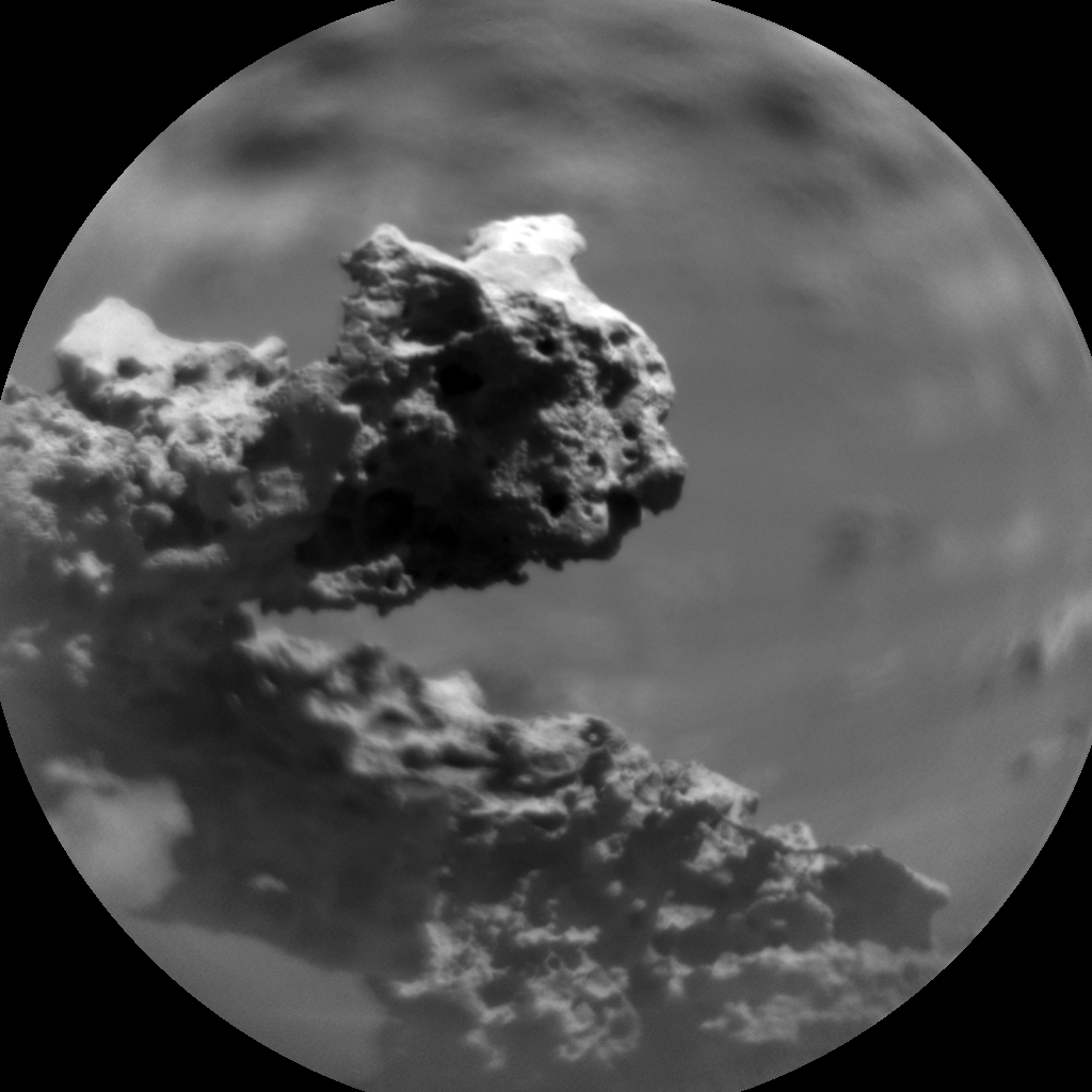
English: This image was taken by Chemistry & Camera (ChemCam) onboard NASA's Mars rover Curiosity on Sol 3190 (2021-07-27 19:28:59 UTC).
https://mars.nasa.gov/raw_images/957712/?site=msl https://gizmodo.com/curiosity-rover-sees-a-weird-martian-rock-formation-1847414397 https://www.cnet.com/news/nasa-mars-rover-spots-whimsical-rock-arch-defying-wind-and-dust/ https://mars.nasa.gov/msl/mission-updates/9001/sols-3192-3193-whimsical-rock-textures/ MISSION UPDATES | July 28, 2021 Sols 3192-3193: Whimsical Rock Textures Written by Abigail Fraeman, Planetary Geologist at NASA's Jet Propulsion Laboratory This is a black and white image of clouds taken by the Mars rover Curiosity. The clouds are dark and dense. This image was taken by Chemistry & Camera (ChemCam) onboard NASA's Mars rover Curiosity on Sol 3190. Credits: NASA/JPL-Caltech/LANL. Download image › Curiosity is continuing to climb through an area where orbital data show the layers of Mount Sharp are transitioning from clay-bearing to sulfate-bearing. I continue to be dazzled by the textures we’re seeing, especially the prevalence of centimeter sized bumps and lumps poking out of the bedrock. We captured a particularly whimsical image of an interesting rock texture in a ChemCam RMI image yestersol, shown above. The whole field of view is about 16.5 cm across, so this is a very tiny feature! Our plans for sols 3192 and 3193 include contact science, remote sensing, and driving. We’ll observe a nodular bedrock target named "Champeaux" with APXS and MAHLI first thing in the morning on sol 3192. Then we’ll capture Mastcam and ChemCam RMI mosaics of some of the scenic terrain surrounding Curiosity, a ChemCam LIBS observation of “Manaurie,” and additional Mastcam images of surrounding outcrops. After wrapping up science at this site, we’ll drive along our strategic route up Mount Sharp and spend the second sol of the plan collecting observations that monitor the environment. We’ll also acquire a ChemCam autonomously selected AEGIS observation. |
| Date | |
| Source | https://mars.nasa.gov/msl-raw-images/proj/msl/redops/ods/surface/sol/03190/soas/rdr/ccam/CR0_680683334PRC_F0892638CCAM02190L1.PNG |
| Author | NASA/JPL-Caltech/LANL |
Licensing
[edit]
| This file is in the public domain in the United States because it was solely created by NASA. NASA copyright policy states that "NASA material is not protected by copyright unless noted". (See Template:PD-USGov, NASA copyright policy page or JPL Image Use Policy.) | ||
 |
Warnings:
|
File history
Click on a date/time to view the file as it appeared at that time.
| Date/Time | Thumbnail | Dimensions | User | Comment | |
|---|---|---|---|---|---|
| current | 15:04, 4 August 2021 | | 1,024 × 1,024 (584 KB) | Drbogdan (talk | contribs) | Uploaded a work by NASA/JPL-Caltech/LANL from https://mars.nasa.gov/msl-raw-images/proj/msl/redops/ods/surface/sol/03190/soas/rdr/ccam/CR0_680683334PRC_F0892638CCAM02190L1.PNG with UploadWizard |
You cannot overwrite this file.
File usage on Commons
There are no pages that use this file.
File usage on other wikis
The following other wikis use this file:
- Usage on en.wikipedia.org
- Usage on zh.wikipedia.org