File:Marquez dome AR5820030451618.jpg
Jump to navigation
Jump to search

Size of this preview: 600 × 600 pixels. Other resolutions: 240 × 240 pixels | 480 × 480 pixels | 768 × 768 pixels | 1,024 × 1,024 pixels | 1,400 × 1,400 pixels.
Original file (1,400 × 1,400 pixels, file size: 491 KB, MIME type: image/jpeg)
Captions
Captions
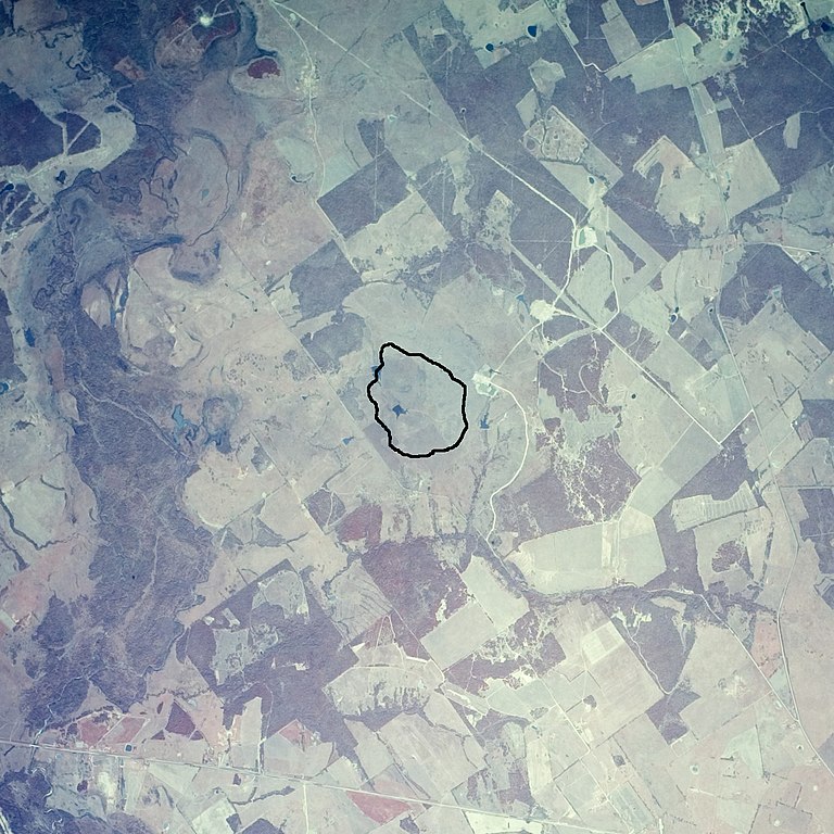
Cretaceous rocks at center of Marquez dome
Summary
[edit]
| Description |
English: Black outline shows extent of Cretaceous rocks in the center of the Marquez Dome, which is a buried impact crater. The air photo is dated 8 March 1982. The outline is based on Geologic atlas of Texas, Waco sheet, dated 1970. Texas Highway 7 crosses diagonally at the bottom of the image and the town of Marquez lies out of the frame beyond the southeast corner. The Navasota River trends north-south along the left edge. The image is approximately 7.5 km wide. |
| Date | |
| Source | EarthExplorer, air photo single frame AR5820030451618 |
| Author | James Stuby, modified from USGS air photo |
Licensing
[edit]
| This file is made available under the Creative Commons CC0 1.0 Universal Public Domain Dedication. | |
| The person who associated a work with this deed has dedicated the work to the public domain by waiving all of their rights to the work worldwide under copyright law, including all related and neighboring rights, to the extent allowed by law. You can copy, modify, distribute and perform the work, even for commercial purposes, all without asking permission.
|
File history
Click on a date/time to view the file as it appeared at that time.
| Date/Time | Thumbnail | Dimensions | User | Comment | |
|---|---|---|---|---|---|
| current | 20:31, 3 May 2019 | | 1,400 × 1,400 (491 KB) | Jstuby (talk | contribs) | User created page with UploadWizard |
You cannot overwrite this file.
File usage on Commons
There are no pages that use this file.
File usage on other wikis
The following other wikis use this file:
- Usage on en.wikipedia.org