File:Maria 2017 track.png
Jump to navigation
Jump to search

Size of this preview: 800 × 554 pixels. Other resolutions: 320 × 222 pixels | 640 × 443 pixels | 1,024 × 710 pixels | 1,280 × 887 pixels | 2,700 × 1,871 pixels.
Original file (2,700 × 1,871 pixels, file size: 1.23 MB, MIME type: image/png)
Captions
Captions
Add a one-line explanation of what this file represents
Summary
| Description |
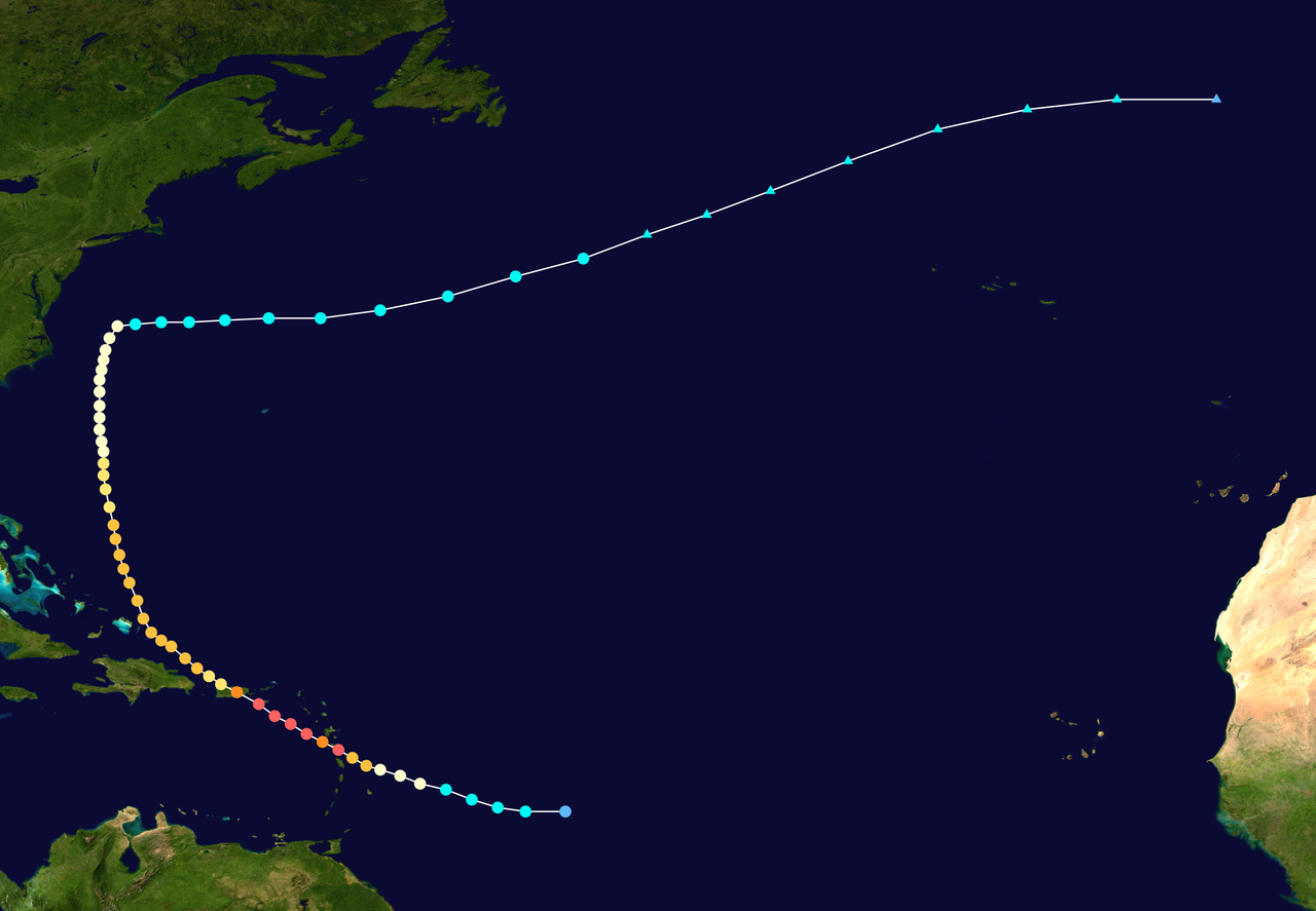
English: Track map of Hurricane Maria of the 2017 Atlantic hurricane season. The points show the location of the storm at 6-hour intervals. The colour represents the storm's maximum sustained wind speeds as classified in the (see below), and the shape of the data points represent the nature of the storm, according to the legend below. Tropical depression (≤38 mph, ≤62 km/h)
Tropical storm (39–73 mph, 63–118 km/h)
Category 1 (74–95 mph, 119–153 km/h)
Category 2 (96–110 mph, 154–177 km/h)
Category 3 (111–129 mph, 178–208 km/h)
Category 4 (130–156 mph, 209–251 km/h)
Category 5 (≥157 mph, ≥252 km/h)
Unknown
Storm type |
||
| Date | 2017-09-16–2017-10-02 | ||
| Source | Created by Cyclonebiskit using Wikipedia:WikiProject Tropical cyclones/Tracks. The background image is from NASA. Tracking data is from the National Hurricane Center[1]. | ||
| Author | Cyclonebiskit | ||
| Source code | Track map data table, if present below, is in HURDAT2 or ATCF format. See format details in [2] and [3], respectively.
|
Licensing
[edit]| This work has been released into the public domain by its author, Cyclonebiskit. This applies worldwide. In some countries this may not be legally possible; if so: Cyclonebiskit grants anyone the right to use this work for any purpose, without any conditions, unless such conditions are required by law. |
File history
Click on a date/time to view the file as it appeared at that time.
| Date/Time | Thumbnail | Dimensions | User | Comment | |
|---|---|---|---|---|---|
| current | 08:21, 28 July 2019 | | 2,700 × 1,871 (1.23 MB) | Supportstorm (talk | contribs) | Corrections from HURDAT |
| 21:53, 9 April 2018 |  | 3,000 × 2,079 (1.82 MB) | Cyclonebiskit (talk | contribs) | TCR update | |
| 18:42, 9 April 2018 |  | 3,000 × 2,079 (1.17 MB) | Jasper Deng (talk | contribs) | Final revision necessary: include ET portion | |
| 18:35, 9 April 2018 |  | 3,000 × 2,520 (1.46 MB) | Jasper Deng (talk | contribs) | TCR update. The software is a bit finicky. | |
| 10:31, 6 October 2017 |  | 3,000 × 2,290 (2.63 MB) | MarioProtIV (talk | contribs) | Reverted to version as of 21:33, 4 October 2017 (UTC) it usually gets shortened after the storm, and it makes the season map cluttered | |
| 03:59, 6 October 2017 |  | 3,000 × 2,290 (2.22 MB) | MarioJump83 (talk | contribs) | Reverted to version as of 16:31, 2 October 2017 (UTC) MarioProtIV: I (and probably others) would prefer the ones that have points before it got PTC status. The ones without it would make it look more empty, and unlike previous years for the first time... | |
| 21:33, 4 October 2017 |  | 3,000 × 2,290 (2.63 MB) | MarioProtIV (talk | contribs) | remove precursor points (except the POTC one) | |
| 16:31, 2 October 2017 |  | 3,000 × 2,290 (2.22 MB) | Cyclonebiskit (talk | contribs) | Update | |
| 14:20, 1 October 2017 |  | 3,000 × 2,555 (2.14 MB) | Cyclonebiskit (talk | contribs) | Update | |
| 15:18, 28 September 2017 |  | 3,000 × 2,307 (2.1 MB) | Cyclonebiskit (talk | contribs) | Update |
You cannot overwrite this file.
File usage on Commons
The following page uses this file:
File usage on other wikis
The following other wikis use this file:
- Usage on cs.wikipedia.org
- Usage on de.wikipedia.org
- Usage on en.wikipedia.org
- Usage on es.wikipedia.org
- Usage on fi.wikipedia.org
- Usage on fr.wikipedia.org
- Usage on he.wikipedia.org
- Usage on hu.wikipedia.org
- Usage on it.wikipedia.org
- Usage on ja.wikipedia.org
- Usage on ko.wikipedia.org
- Usage on nl.wikipedia.org
- Usage on pl.wikipedia.org
- Usage on pt.wikipedia.org
- Usage on simple.wikipedia.org
- Usage on sv.wikipedia.org
- Usage on th.wikipedia.org
- Usage on vi.wikipedia.org
- Usage on www.wikidata.org
- Usage on zh.wikipedia.org