File:Mari 1764 BC-He.svg
Jump to navigation
Jump to search

Size of this PNG preview of this SVG file: 800 × 590 pixels. Other resolutions: 320 × 236 pixels | 640 × 472 pixels | 1,024 × 755 pixels | 1,280 × 944 pixels | 2,560 × 1,889 pixels | 1,525 × 1,125 pixels.
Original file (SVG file, nominally 1,525 × 1,125 pixels, file size: 2.66 MB)
Captions
Captions
Add a one-line explanation of what this file represents
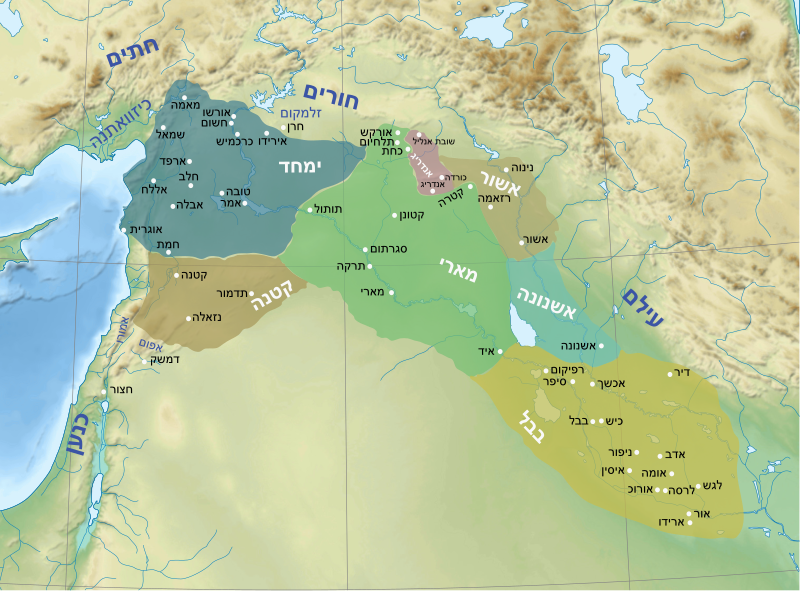
| Description | מפת הממלכות הגדולות במסופוטמיה בשנת 1764 לפנה"ס, לפני כיבוש מארי על ידי בבל. הממלכות הבולטות: ימחד, מארי, קטנה, אשנונה ובבל | ||
| Date | (UTC) | ||
| Source | Image:Near East topographic map-blank.svg | ||
| Author | Sémhur | ||
| Permission (Reusing this file) |
I, the copyright holder of this work, hereby publish it under the following licenses:
This file is licensed under the Creative Commons Attribution-Share Alike Attribution-Share Alike 4.0 International, 3.0 Unported, 2.5 Generic, 2.0 Generic and 1.0 Generic license.
You may select the license of your choice. |
File history
Click on a date/time to view the file as it appeared at that time.
| Date/Time | Thumbnail | Dimensions | User | Comment | |
|---|---|---|---|---|---|
| current | 19:11, 18 June 2016 | | 1,525 × 1,125 (2.66 MB) | קרלוס הגדול (talk | contribs) | . |
| 13:09, 16 February 2016 |  | 1,525 × 1,125 (2.66 MB) | בשש (talk | contribs) | {{Information |Description=Mari 1764 |Source=Image:Near East topographic map-blank.svg |Date=~~~~~ |Author=Sémhur |Permission={{self|FAL|cc-by-sa-all}} |other_versions= }} |
You cannot overwrite this file.
File usage on Commons
The following page uses this file:
File usage on other wikis
The following other wikis use this file:
- Usage on he.wikipedia.org
- מארי
- אשנונה
- פורטל:ארכאולוגיה של המזרח הקרוב/הידעת?/קטעי הידעת?
- פורטל:היסטוריה/הידעת?/קטעי הידעת 2
- ויקיפדיה:ערכים מומלצים/המלצות קודמות/יוני 2016
- ויקיפדיה:סדנה לגרפיקה/ארכיון 38
- קטנה (עיר מדינה)
- פורטל:העת העתיקה/מאמר נבחר/אוסף ערכים נבחרים
- ויקיפדיה:הידעת?/ממרץ 2016
- ימחד
- ירים-ליאם הראשון
- אירידו
- אורשו
- חשום
- ויקיפדיה:הידעת?/2016/מרץ
- פורטל:ארכאולוגיה של המזרח הקרוב/הידעת?/68
- תבנית:הידעת? 22 במרץ 2016
- תבנית:הידעת? 057
- פורטל:ערכים מומלצים/ערכים/ימחד
- תבנית:ערך מומלץ 3 ביוני 2016
- תבנית:ערך מומלץ 4 ביוני 2016
- פורטל:העת העתיקה/מאמר נבחר/12
- ויקיפדיה:סדנה לגרפיקה/ארכיון 39
- ויקיפדיה:ערכים מומלצים/המלצות קודמות/אפריל 2020
- פורטל:דואר ובולאות/ציטוט נבחר/אוסף ציטוטים
- פורטל:דואר ובולאות/ציטוט נבחר/74
- תבנית:ערך מומלץ 23 באפריל 2020
- תבנית:ערך מומלץ 24 באפריל 2020
- ויקיפדיה:הידעת?/2020/ספטמבר
- פורטל:אישים/הידעת?/קטעי הידעת? - 3
- תבנית:הידעת? 21 בספטמבר 2020
- ויקיפדיה:ערכים מומלצים/המלצות קודמות/ינואר 2023
- משתמש:Gilgamesh/בדיקת נגישות תקצירי ערכים
- פורטל:אישים/הידעת?/235
- תבנית:ערך מומלץ 10 בינואר 2023
- פורטל:היסטוריה/הידעת?/160