File:Maps of Vietnam during the reign of Emperor Minh Mạng (1820-1841).png
Jump to navigation
Jump to search
Size of this preview: 483 × 599 pixels. Other resolutions: 193 × 240 pixels | 387 × 480 pixels | 619 × 768 pixels | 825 × 1,024 pixels | 2,000 × 2,482 pixels.
Original file (2,000 × 2,482 pixels, file size: 367 KB, MIME type: image/png)
Captions
Captions
Add a one-line explanation of what this file represents
Summary
[edit].png&action=edit§ion=1)
| Description |
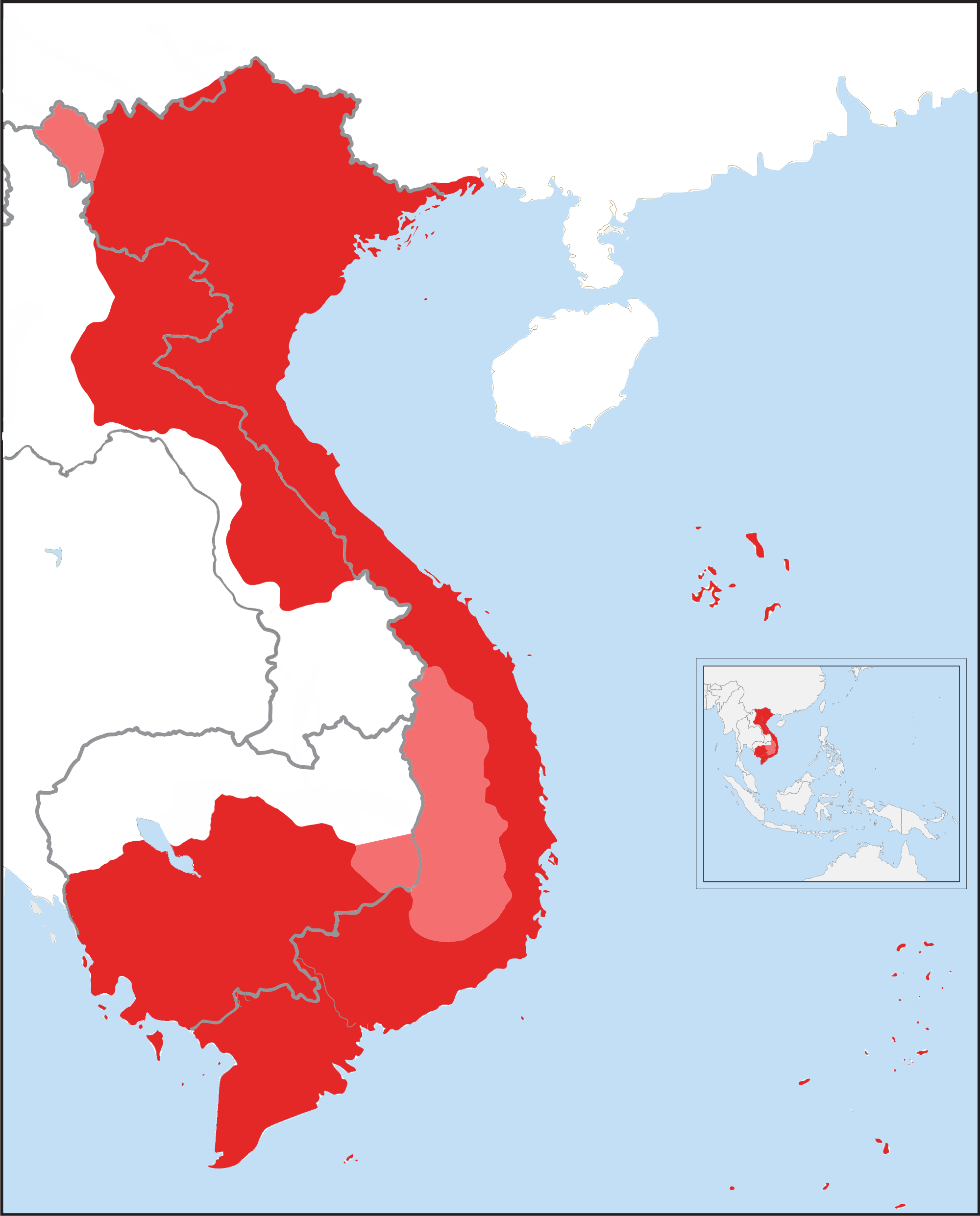
Tiếng Việt: Quốc thổ An Nam dưới triều Minh Mệnh 明命, bao gồm cả các trấn ở Lào. Vùng thuộc phần đất Campuchia ngày nay là lãnh thổ Trấn Tây Thành 鎮西城 mà nhà Nguyễn chiếm được trong 7 năm (1834-1841) trước khi bị đánh đuổi. Bản đồ bao gồm cả các các vùng đất bị cắt cho nhà Thanh năm 1887 theo công ước Pháp-Thanh, vẽ đè lên biên giới ngày nay.
Lãnh thổ được cai trị trực tiếp từ Huế Các vùng đất phiên thuộc Đại Nam, bao gồm Nam Bàn và 12 xứ Thái |
| Date | |
| Source | Own work |
| Author | 段黎志寶 |
Licensing
[edit].png&action=edit§ion=2)
I, the copyright holder of this work, hereby publish it under the following license:
This file is licensed under the Creative Commons Attribution-Share Alike 4.0 International license.
- You are free:
- to share – to copy, distribute and transmit the work
- to remix – to adapt the work
- Under the following conditions:
- attribution – You must give appropriate credit, provide a link to the license, and indicate if changes were made. You may do so in any reasonable manner, but not in any way that suggests the licensor endorses you or your use.
- share alike – If you remix, transform, or build upon the material, you must distribute your contributions under the same or compatible license as the original.
File history
Click on a date/time to view the file as it appeared at that time.
| Date/Time | Thumbnail | Dimensions | User | Comment | |
|---|---|---|---|---|---|
| current | 01:58, 25 March 2020 | | 2,000 × 2,482 (367 KB) | A (talk | contribs) | Correct boundary |
| 20:24, 22 December 2014 |  | 2,000 × 2,482 (349 KB) | TRMC (talk | contribs) | User created page with UploadWizard |
You cannot overwrite this file.
File usage on Commons
There are no pages that use this file.
File usage on other wikis
The following other wikis use this file:
- Usage on de.wikipedia.org
- Usage on en.wikipedia.org
- Usage on es.wikipedia.org
- Usage on fr.wikipedia.org
- Usage on lo.wikipedia.org
- Usage on sl.wikipedia.org
- Usage on uk.wikipedia.org
- Usage on vi.wikipedia.org
.png&oldid=905048808)