File:Maps TDWR fr.svg
Jump to navigation
Jump to search

Size of this PNG preview of this SVG file: 800 × 522 pixels. Other resolutions: 320 × 209 pixels | 640 × 418 pixels | 1,024 × 669 pixels | 1,280 × 836 pixels | 2,560 × 1,672 pixels | 908 × 593 pixels.
Original file (SVG file, nominally 908 × 593 pixels, file size: 430 KB)
Captions
Captions
Add a one-line explanation of what this file represents
Summary
[edit]
| Description |
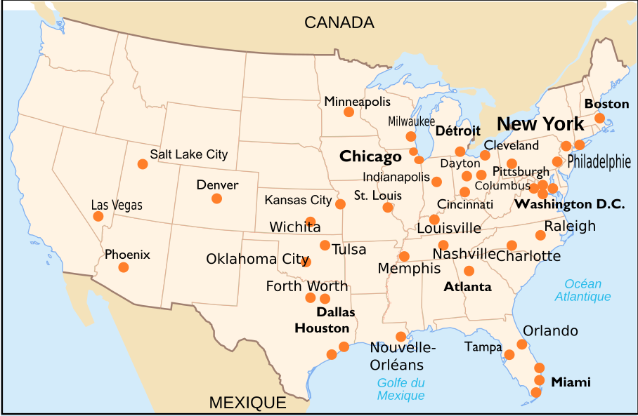
Français : Cartes des sites où on retrouve des radars météorologiques du réseau américain Terminal Doppler Weather Radar. Il manque le radar à San Juan de Porto-Rico |
| Date | |
| Source | Own work based on: Carte des villes américaines.svg as Background, data from Lincoln Laboratory, NWS and Weather Underground |
| Author | Pierre cb |
| Other versions | Derivative works of this file: Map TDWR.svg |
| SVG development |
Licensing
[edit]
I, the copyright holder of this work, hereby publish it under the following licenses:

|
Permission is granted to copy, distribute and/or modify this document under the terms of the GNU Free Documentation License, Version 1.2 or any later version published by the Free Software Foundation; with no Invariant Sections, no Front-Cover Texts, and no Back-Cover Texts. A copy of the license is included in the section entitled GNU Free Documentation License. |
This file is licensed under the Creative Commons Attribution-Share Alike 3.0 Unported, 2.5 Generic, 2.0 Generic and 1.0 Generic license.
- You are free:
- to share – to copy, distribute and transmit the work
- to remix – to adapt the work
- Under the following conditions:
- attribution – You must give appropriate credit, provide a link to the license, and indicate if changes were made. You may do so in any reasonable manner, but not in any way that suggests the licensor endorses you or your use.
- share alike – If you remix, transform, or build upon the material, you must distribute your contributions under the same or compatible license as the original.
You may select the license of your choice.
File history
Click on a date/time to view the file as it appeared at that time.
| Date/Time | Thumbnail | Dimensions | User | Comment | |
|---|---|---|---|---|---|
| current | 02:37, 22 August 2017 | | 908 × 593 (430 KB) | Pierre cb (talk | contribs) | Autre petite correction. |
| 02:34, 22 August 2017 |  | 908 × 593 (430 KB) | Pierre cb (talk | contribs) | Petite correction. | |
| 17:51, 17 February 2017 |  | 908 × 593 (430 KB) | Pierre cb (talk | contribs) | Correcting Norman for OKC with reference (https://www.roc.noaa.gov/wsr88d/maps.aspx) | |
| 02:42, 15 April 2013 |  | 908 × 593 (430 KB) | Pierre cb (talk | contribs) | Déplacement plus correct de la postion de Milwaukee (Wiskonsin) et changement de Melbourne pour Orlando en Floride selon la carte de http://www.ll.mit.edu/mission/aviation/faawxsystems/images/tdwr-figure1.jpg | |
| 05:30, 19 September 2009 |  | 908 × 593 (431 KB) | Pierre cb (talk | contribs) | {{Information |Description={{fr|1=Cartes des sites où on retrouve des radars météorologiques du réseau américain Terminal Doppler Weather Radar}} |Source=travail personnel (own work) |Author=[[User:Pierre cb|Pie |
You cannot overwrite this file.
File usage on Commons
The following 3 pages use this file:
File usage on other wikis
The following other wikis use this file:
- Usage on es.wikipedia.org
- Usage on fr.wikipedia.org