File:Mappe-monde par le Sr Robert de Vaugondy - btv1b84909279.jpg
Jump to navigation
Jump to search
Size of this preview: 800 × 500 pixels. Other resolutions: 320 × 200 pixels | 640 × 400 pixels | 1,024 × 640 pixels | 1,280 × 800 pixels | 2,560 × 1,599 pixels | 7,210 × 4,504 pixels.
Original file (7,210 × 4,504 pixels, file size: 5.6 MB, MIME type: image/jpeg)
Captions
Captions
Add a one-line explanation of what this file represents
Summary
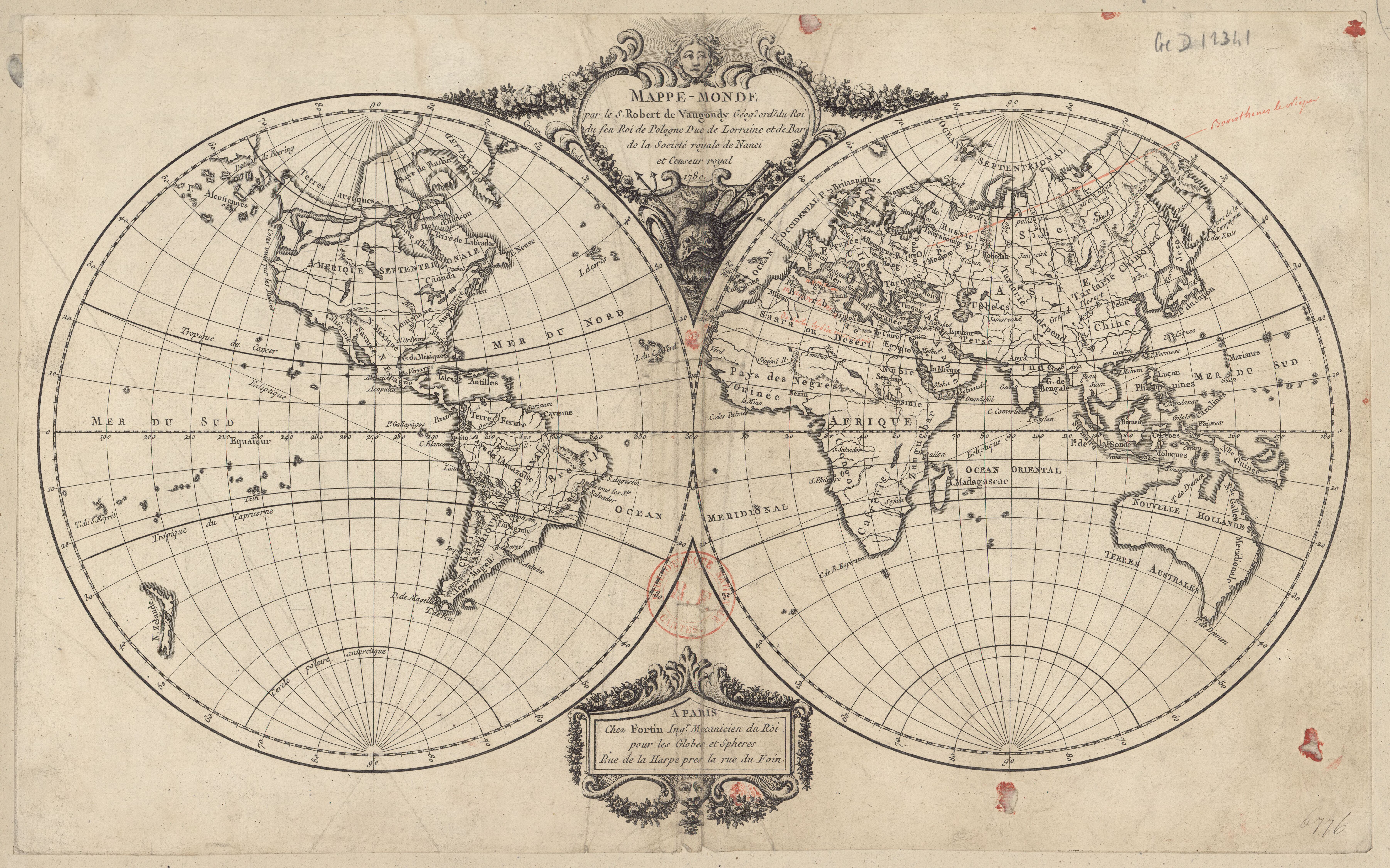
[edit]| Mappe-monde par le Sr Robert de Vaugondy
( |
|||||||||||||||||||||||||||
|---|---|---|---|---|---|---|---|---|---|---|---|---|---|---|---|---|---|---|---|---|---|---|---|---|---|---|---|
| Title |
Mappe-monde par le Sr Robert de Vaugondy |
||||||||||||||||||||||||||
| Description |
Français : Sujet : Monde
Langue : français Éditeur : Fortin (Paris) |
||||||||||||||||||||||||||
| Date | 1780 | ||||||||||||||||||||||||||
| Dimensions | height: 27 cm (10.6 in); width: 43 cm (16.9 in) | ||||||||||||||||||||||||||
| Collection |
|
||||||||||||||||||||||||||
| References |
Français : Notice du catalogue : http://catalogue.bnf.fr/ark:/12148/cb40699847d |
||||||||||||||||||||||||||
| Source/Photographer |
Français : Bibliothèque nationale de France, département Cartes et plans, GE D-12341
Bibliothèque nationale de France |
||||||||||||||||||||||||||
| Permission (Reusing this file) |
|
||||||||||||||||||||||||||
| Other versions |
|
||||||||||||||||||||||||||


.jpg)

_Robert_de_Vaugondy_G%C3%A9ographe_ord(inaire)_du..._-_btv1b550137444_(016_of_183).jpg)


File history
Click on a date/time to view the file as it appeared at that time.
| Date/Time | Thumbnail | Dimensions | User | Comment | |
|---|---|---|---|---|---|
| current | 23:35, 13 August 2022 | | 7,210 × 4,504 (5.6 MB) | Gzen92Bot (talk | contribs) | Gallica btv1b84909279 |
You cannot overwrite this file.
File usage on Commons
The following 13 pages use this file:
- File:1757 – G. R. Vaugondy – Orbis Vetus.jpg
- File:Mappe-Monde dressée suivant les nouvelles relations et assujettie aux observations astronomiques - par le Sr Robert de Vaugondy Geog? - btv1b53119358p.jpg
- File:Mappe-monde - Dressée suivant les nouvelles relations et assujettie aux observations astronomiques par le S. Robert de Vaugondy Geogr. ; Corrigée et augmentée des Nouvelles Découvertes du Capitaine Cook par... - btv1b53176414f.jpg
- File:Mappe-monde par le Sr Robert de Vaugondy - btv1b84909279.jpg
- File:Mappemonde dressée suivant les nouvelles relations et assujettie aux observations astronomiques - par le Sr Robert... - btv1b53093290h.jpg
- File:Mappemonde dressée suivant les nouvelles relations et assujettie aux observations astronomiques - par le Sr Robert... - btv1b53093292d.jpg
- File:Mappemonde dressée suivant les nouvelles relations et assujettie aux observations astronomiques - par le Sr Robert... - btv1b53093313x.jpg
- File:Mappemonde ou Description du globe terrestre (4072626326).jpg
- File:Nouvel atlas portatif destiné principalement pour l'instruction de la Jeunesse, d'après la Géographie Moderne de feu l'abbé Delacroix - Par Le S(ieur) Robert de Vaugondy Géographe ord(inaire) du... - btv1b550137444 (016 of 183).jpg
- File:Orbis Vetus in utrâque continente juxta mentem Sansonianam distinctus, nec non observationibus astronomicis redactus accurante Robert de Vaugondy... - btv1b5962753g.jpg
- File:Orbis vetus in utraque continente juxta mentem Sansonianam... - accurante Robert de Vaugondy... - btv1b53093791v.jpg
- File:Orbis vetus in utrâque continente juxtà mentem Sansonianam distinctus, nec non observationibus astronomicis - Norman B. Leventhal Map Center at the BPL.jpg
- File:Vaugondy, Gilles Robert De — Orbis Vetus in utraque continente juxta mentem Sansonianam distinctus, nec non observationibus astonimicis redactus 1752.jpg