File:Mappa di Eratostene-ar.png
Jump to navigation
Jump to search

Size of this preview: 800 × 470 pixels. Other resolutions: 320 × 188 pixels | 640 × 376 pixels | 1,040 × 611 pixels.
Original file (1,040 × 611 pixels, file size: 887 KB, MIME type: image/png)
Captions
Captions
Add a one-line explanation of what this file represents
Summary
[edit]
| Description |
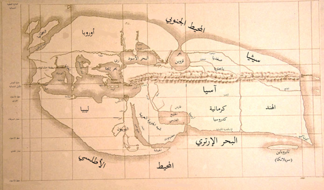
العربية: خريطة العالم المعروف لإراتوستينس المُعاد إنشاؤها خلال القرن التاسع عشر. رُسمت الخريطة الأصلية قرابة عام 194 ق.م. |
| Date | (UTC) |
| Source |
This file was derived from: Mappa di Eratostene.jpg: |
| Author |
|
| This is a retouched picture, which means that it has been digitally altered from its original version. Modifications: translated to Arabic. The original can be viewed here: Mappa di Eratostene.jpg:
|
Licensing
[edit]
This work is in the public domain in the United States because it was published (or registered with the U.S. Copyright Office) before January 1, 1929.
|
|
This is a faithful photographic reproduction of a two-dimensional, public domain work of art. The work of art itself is in the public domain for the following reason:
The official position taken by the Wikimedia Foundation is that "faithful reproductions of two-dimensional public domain works of art are public domain". This photographic reproduction is therefore also considered to be in the public domain in the United States. In other jurisdictions, re-use of this content may be restricted; see Reuse of PD-Art photographs for details. {{PD-Art}} template without license parameter: please specify why the underlying work is public domain in both the source country and the United States
(Usage: {{PD-Art|1=|deathyear=''year of author's death''|country=''source country''}}, where parameter 1= can be PD-old-auto, PD-old-auto-expired, PD-old-auto-1996, PD-old-100 or similar. See Commons:Multi-license copyright tags for more information.) | ||||
Original upload log
[edit]
This image is a derivative work of the following images:
- File:Mappa_di_Eratostene.jpg licensed with PD-1923, PD-Art, PD-old
- 2007-06-24T19:12:54Z TcfkaPanairjdde 1040x611 (152065 Bytes) Mappa di Eratostene, da en.wiki [[en:Iran.jpg]] La mappa è tratta da: * Bunbury, E.H., ''A History of Ancient Geography among the Greeks and Romans from the Earliest Ages till the Fall of the Roman Empire''. London: John Mu
Uploaded with derivativeFX
File history
Click on a date/time to view the file as it appeared at that time.
| Date/Time | Thumbnail | Dimensions | User | Comment | |
|---|---|---|---|---|---|
| current | 16:13, 4 July 2012 | | 1,040 × 611 (887 KB) | باسم (talk | contribs) | == {{int:filedesc}} == {{Information |Description={{ar|خريطة العالم المعروف لإراتوستينس المُعاد إنشاؤها خلال القرن التاسع عشر. رُسمت الخريطة الأصلية قرابة عام 194 ... |
You cannot overwrite this file.
File usage on Commons
There are no pages that use this file.
File usage on other wikis
The following other wikis use this file:
- Usage on ar.wikipedia.org
- Usage on arz.wikipedia.org