File:Mappa delle chiese di Gaeta dentro le mura.png
Jump to navigation
Jump to search

Size of this preview: 800 × 488 pixels. Other resolutions: 320 × 195 pixels | 640 × 390 pixels | 1,024 × 625 pixels | 1,280 × 781 pixels | 2,560 × 1,561 pixels | 3,825 × 2,333 pixels.
Original file (3,825 × 2,333 pixels, file size: 1.89 MB, MIME type: image/png)
Captions
Captions
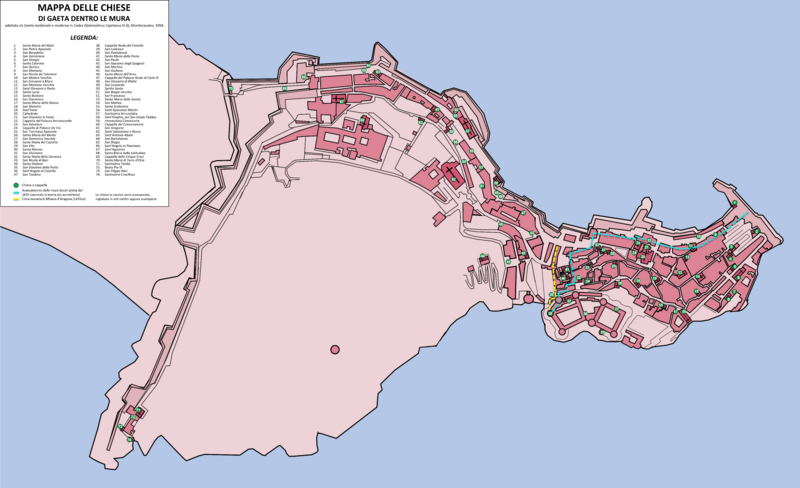
This is very interesting map of the churches in the medieval city of Gaeta. This is very helpful while reading many and many documents making possible to locate places mentioned in those documents
Summary
[edit]
| Description |
Italiano: Mappa delle chiese di Gaeta dentro le mura, adattata da "Gaeta medievale e moderna" in "Codex Diplomaticus Cajetanus" III (I), Montecassino, 1958. |
| Date | |
| Source | Own work |
| Author | Fraudo182 |
Licensing
[edit]
I, the copyright holder of this work, hereby publish it under the following license:
This file is licensed under the Creative Commons Attribution-Share Alike 4.0 International license.
- You are free:
- to share – to copy, distribute and transmit the work
- to remix – to adapt the work
- Under the following conditions:
- attribution – You must give appropriate credit, provide a link to the license, and indicate if changes were made. You may do so in any reasonable manner, but not in any way that suggests the licensor endorses you or your use.
- share alike – If you remix, transform, or build upon the material, you must distribute your contributions under the same or compatible license as the original.
File history
Click on a date/time to view the file as it appeared at that time.
| Date/Time | Thumbnail | Dimensions | User | Comment | |
|---|---|---|---|---|---|
| current | 09:25, 18 October 2021 | | 3,825 × 2,333 (1.89 MB) | Fraudo182 (talk | contribs) | Modifiche nella legenda |
| 21:58, 23 August 2021 |  | 11,191 × 6,782 (5.94 MB) | Fraudo182 (talk | contribs) | Reverted to version as of 14:16, 22 July 2021 (UTC) | |
| 23:17, 22 July 2021 |  | 11,194 × 6,799 (5.95 MB) | Fraudo182 (talk | contribs) | "Santa Maria di Sanità" è corretto in "Santa Maria della Carità" | |
| 14:16, 22 July 2021 |  | 11,191 × 6,782 (5.94 MB) | Fraudo182 (talk | contribs) | Cross-wiki upload from it.wikipedia.org |
You cannot overwrite this file.
File usage on Commons
The following page uses this file:
File usage on other wikis
The following other wikis use this file:
- Usage on de.wikivoyage.org
- Usage on it.wikipedia.org
- Usage on www.wikidata.org