File:Mapa kropkowa powiat otwocki.jpg
Jump to navigation
Jump to search

Size of this preview: 548 × 599 pixels. Other resolutions: 219 × 240 pixels | 439 × 480 pixels | 675 × 738 pixels.
Original file (675 × 738 pixels, file size: 88 KB, MIME type: image/jpeg)
Captions
Captions
Add a one-line explanation of what this file represents
Summary
[edit]
| Description |
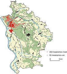
Polski: Mapa kropkowa wielowagowa – mapa rozmieszczenia ludności powiatu otwockiego w 2011 roku (wg Narodowego Spisu Powszechnego 2011) |
| Date | |
| Source | Prezentacja danych na mapach. in: Marek Pieniążek, Barbara Szejgiec, Maciej Zych: Graficzna prezentacja danych statystycznych. Wykresy, mapy, GIS. Warszawa: Główny Urząd Statystyczny, 2014 [1] |
| Author | Maciej Zych |
Licensing
[edit]
This file is licensed under the Creative Commons Attribution 3.0 Unported license.
- You are free:
- to share – to copy, distribute and transmit the work
- to remix – to adapt the work
- Under the following conditions:
- attribution – You must give appropriate credit, provide a link to the license, and indicate if changes were made. You may do so in any reasonable manner, but not in any way that suggests the licensor endorses you or your use.
File history
Click on a date/time to view the file as it appeared at that time.
| Date/Time | Thumbnail | Dimensions | User | Comment | |
|---|---|---|---|---|---|
| current | 08:43, 22 December 2014 | | 675 × 738 (88 KB) | Aotearoa (talk | contribs) | User created page with UploadWizard |
You cannot overwrite this file.
File usage on Commons
There are no pages that use this file.
File usage on other wikis
The following other wikis use this file:
- Usage on pl.wikipedia.org