File:Mapa general de la Republica de la Guatemala. LOC 2012586638.jpg
Jump to navigation
Jump to search

Size of this preview: 676 × 599 pixels. Other resolutions: 271 × 240 pixels | 541 × 480 pixels | 866 × 768 pixels | 1,155 × 1,024 pixels | 2,310 × 2,048 pixels | 12,451 × 11,040 pixels.
Original file (12,451 × 11,040 pixels, file size: 18.95 MB, MIME type: image/jpeg)
Captions
Captions
Add a one-line explanation of what this file represents
Summary
[edit]| Warning | The original file is very high-resolution. It might not load properly or could cause your browser to freeze when opened at full size. |
|---|
| Description |
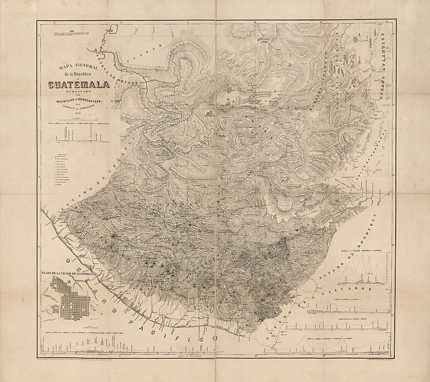
English: Relief shown by hachures. "Entered according to act of Congress in the year 1859 by M. v. Sonnenstern in the Clerks Office of the District Court of the Southern District of New York." "Nota. El mapa de la Republica de Guatemala levantado por August van de Gehuchte y examinado y revisado en sus puntos principales topograficos segun las ordenes del S.G. por Maximilian v. Sonnenstern." Includes ancillary map of "Plano de la ciudad de Guatemala" and 6 relief profiles. In lower right margin: G. Kraetzer lith, East New York Long Island, N.Y. Available also through the Library of Congress Web site as a raster image. |
||
| Title | Mapa general de la Republica de la Guatemala. | ||
| Shelf ID | G4810 1859 .S6 | ||
| Date | |||
| Source | https://www.loc.gov/item/2012586638/ | ||
| Author | Sonnenstern, Maximilian Von; Gehuchte, August Van De. | ||
| Permission (Reusing this file) |
|
||
| Other versions |
|
||
| Location | Guatemala | ||
| Part of | American Memory · General Maps · Catalog · Geography And Map Division | ||
| Subject | Maps · Guatemala |

Licensing
[edit]
|
This is a faithful photographic reproduction of a two-dimensional, public domain work of art. The work of art itself is in the public domain for the following reason:
The official position taken by the Wikimedia Foundation is that "faithful reproductions of two-dimensional public domain works of art are public domain".
This photographic reproduction is therefore also considered to be in the public domain in the United States. In other jurisdictions, re-use of this content may be restricted; see Reuse of PD-Art photographs for details. | ||||
File history
Click on a date/time to view the file as it appeared at that time.
| Date/Time | Thumbnail | Dimensions | User | Comment | |
|---|---|---|---|---|---|
| current | 22:27, 25 May 2018 | | 12,451 × 11,040 (18.95 MB) | Fæ (talk | contribs) | LOC Maps https://www.loc.gov/item/2012586638/ #1273 |
You cannot overwrite this file.
File usage on Commons
The following page uses this file: