File:Mapa físico de localización Yarowilca.svg
Jump to navigation
Jump to search

Size of this PNG preview of this SVG file: 512 × 450 pixels. Other resolutions: 273 × 240 pixels | 546 × 480 pixels | 874 × 768 pixels | 1,165 × 1,024 pixels | 2,330 × 2,048 pixels.
Original file (SVG file, nominally 512 × 450 pixels, file size: 821 KB)
Captions
Captions
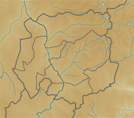
Physical map of Yarowilca, parameters are equal to
Summary
[edit]
| Description |
Español: Mapa físico de localización de Yarowilca.
English: Physical map of Yarowilca, parameters are equal to File:Mapa de localización Yarowilca.svg |
| Date | |
| Source | Own work |
| Author | Waterloo1883 |
Licensing
[edit]
I, the copyright holder of this work, hereby publish it under the following license:
This file is licensed under the Creative Commons Attribution-Share Alike 4.0 International license.
- You are free:
- to share – to copy, distribute and transmit the work
- to remix – to adapt the work
- Under the following conditions:
- attribution – You must give appropriate credit, provide a link to the license, and indicate if changes were made. You may do so in any reasonable manner, but not in any way that suggests the licensor endorses you or your use.
- share alike – If you remix, transform, or build upon the material, you must distribute your contributions under the same or compatible license as the original.
File history
Click on a date/time to view the file as it appeared at that time.
| Date/Time | Thumbnail | Dimensions | User | Comment | |
|---|---|---|---|---|---|
| current | 03:22, 28 January 2021 | | 512 × 450 (821 KB) | Waterloo1883 (talk | contribs) | Cambio de colores y grosor de de los límites administrativos. |
| 00:21, 11 April 2020 |  | 512 × 448 (821 KB) | Waterloo1883 (talk | contribs) | Uploaded own work with UploadWizard |
You cannot overwrite this file.
File usage on Commons
There are no pages that use this file.
File usage on other wikis
The following other wikis use this file:
- Usage on es.wikipedia.org
- Usage on fr.wikipedia.org
- Usage on ru.wikipedia.org