File:Mapa euskotren.svg
Jump to navigation
Jump to search

Size of this PNG preview of this SVG file: 800 × 333 pixels. Other resolutions: 320 × 133 pixels | 640 × 266 pixels | 1,024 × 426 pixels | 1,280 × 533 pixels | 2,560 × 1,065 pixels | 1,550 × 645 pixels.
Original file (SVG file, nominally 1,550 × 645 pixels, file size: 394 KB)
Captions
Captions
Add a one-line explanation of what this file represents
Summary
[edit]
| Description |
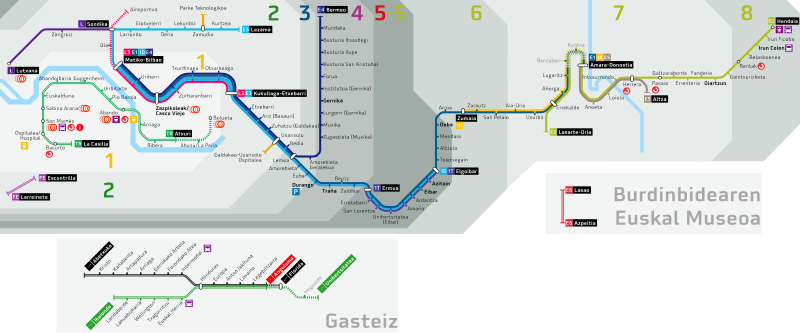
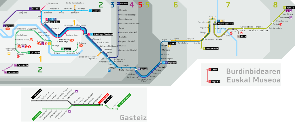
Euskara: Eusko Trenbideak-en sarearen mapa (2010/09/09an eguneratua) Español: Mapa de red de Eusko Trenbideak (actualizado a 2019/09/09) English: Eusko Trenbideak network map (updated to 2019/09/09) |
| Date | |
| Source | Own work |
| Author | Laukatu |
Licensing
[edit]
I, the copyright holder of this work, hereby publish it under the following license:
This file is licensed under the Creative Commons Attribution-Share Alike 3.0 Unported license.
- You are free:
- to share – to copy, distribute and transmit the work
- to remix – to adapt the work
- Under the following conditions:
- attribution – You must give appropriate credit, provide a link to the license, and indicate if changes were made. You may do so in any reasonable manner, but not in any way that suggests the licensor endorses you or your use.
- share alike – If you remix, transform, or build upon the material, you must distribute your contributions under the same or compatible license as the original.
File history
Click on a date/time to view the file as it appeared at that time.
| Date/Time | Thumbnail | Dimensions | User | Comment | |
|---|---|---|---|---|---|
| current | 20:44, 8 September 2019 | | 1,550 × 645 (394 KB) | Laukatu (talk | contribs) | Eguneraketa 2019/09/09 Atxuri Kukullaga-Etxebarri tartea itxi eta E4 linea L3 lineatik sartzen da Bilbora; eta zuzenketa eta aldaketa estetikoak. Actualización a 09/09/2019 tras la supresión del tramo Atxuri Kukullaga-Etxebarri y la entrada de la línea E4 a Bilbao por la L3; otras correcciones y cambios estéticos. |
| 00:53, 28 November 2017 |  | 1,550 × 645 (958 KB) | Laukatu (talk | contribs) | Eguneraketa 2017/11/27 Trianasko geltokia ezeztatu ondoren. Actualización a 27/11/2017 tras la supresión de la construcción de la parada de Trianas. http://www.irekia.euskadi.eus/eu/news/42504-ampliacion-del-tranvia-vitoria-gasteiz-universidad-supri... | |
| 19:41, 22 June 2017 |  | 1,550 × 645 (964 KB) | Laukatu (talk | contribs) | Eguneraketa 2017/06/19 E1 linearen aldaketen ondoren, linea honetako trenak L3tik sartzen da Matikora arte, Bolueta-Atxuri tartea zeharkatu ordez. Actualización a 19/06/2017 tras el cambio en la línea E1, que ahora entra por L3 hasta Matiko, en lugar... | |
| 19:01, 17 May 2017 |  | 1,550 × 645 (923 KB) | Laukatu (talk | contribs) | Eguneraketa 2017/05/13 Eusko Jaurlaritzak adierazi du Donostiako pasantearen lanak udazkenean hasiko direla http://www.ets-rfv.euskadi.eus/albistea/2017/topoaren-tren-saihesbidearen-lanak-udazkenean/v86-ets9999/eu/ Actualización a 13/05/2017 tras el... | |
| 20:13, 14 May 2017 |  | 1,550 × 645 (908 KB) | Laukatu (talk | contribs) | Eguneraketa 2017/05/12 7. Gunean aldaketak Actualización 12/05/2017 cambios en Zona 7 http://www.euskotren.eus/sites/www2.euskotren.es/files/170512%20Tarifa_Orokorra_2017_05_v3.pdf | |
| 19:03, 14 May 2017 |  | 1,550 × 645 (908 KB) | Laukatu (talk | contribs) | Reverted to version as of 15:23, 12 May 2017 (UTC) Pasaia eta Galtzaraborda arteko tartea 8. tarifa-guneari dagokio, Euskotrenen orrialdetik kontsultatuta: http://www.euskotren.eus/sites/www2.euskotren.es/files/Euskotren_Tarifa_Orokorra_2017_04_1.pdf | |
| 19:07, 13 May 2017 | 1,550 × 600 (1,017 KB) | Gorria2005 (talk | contribs) | Reverted to version as of 17:28, 8 April 2017 (UTC). Pasaia eta Gaintxurizketa arteko geltokiak 7. gunean daude, ez 8.ean, | ||
| 15:23, 12 May 2017 |  | 1,550 × 645 (908 KB) | Laukatu (talk | contribs) | Eguneraketa 2017/05/12 Guneak Actualización 12/05/2017 Zonas | |
| 17:28, 8 April 2017 | 1,550 × 600 (1,017 KB) | Laukatu (talk | contribs) | Eguneraketa metroaren 3. eta trenaren E3 lineak ireki ondoren. Actualización tras la apertura de las líneas 3 de Metro y E3 de tren. | ||
| 16:20, 25 September 2016 | 1,550 × 600 (1.5 MB) | Laukatu (talk | contribs) | Zuzenketa testuak ikusgai egiteko |
You cannot overwrite this file.
File usage on Commons
The following 34 pages use this file:
- User:Chumwa/OgreBot/Potential transport maps/2016 September 21-30
- User:Chumwa/OgreBot/Potential transport maps/2017 April 1-10
- User:Chumwa/OgreBot/Potential transport maps/2017 June 21-30
- User:Chumwa/OgreBot/Potential transport maps/2017 May 11-20
- User:Chumwa/OgreBot/Potential transport maps/2017 November 21-30
- User:Chumwa/OgreBot/Potential transport maps/2019 September 1-10
- User:Chumwa/OgreBot/Public transport information/2015 June 1-10
- User:Chumwa/OgreBot/Public transport information/2015 March 21-31
- User:Chumwa/OgreBot/Public transport information/2015 May 21-31
- User:Chumwa/OgreBot/Public transport information/2015 October 21-31
- User:Chumwa/OgreBot/Public transport information/2016 September 21-30
- User:Chumwa/OgreBot/Public transport information/2017 June 21-30
- User:Chumwa/OgreBot/Public transport information/2017 May 11-20
- User:Chumwa/OgreBot/Public transport information/2017 November 21-30
- User:Chumwa/OgreBot/Public transport information/2019 September 1-10
- User:Chumwa/OgreBot/Transport Maps/2015 June 1-10
- User:Chumwa/OgreBot/Transport Maps/2015 March 21-31
- User:Chumwa/OgreBot/Transport Maps/2015 May 21-31
- User:Chumwa/OgreBot/Transport Maps/2015 October 21-31
- User:Chumwa/OgreBot/Transport Maps/2016 September 21-30
- User:Chumwa/OgreBot/Transport Maps/2017 April 1-10
- User:Chumwa/OgreBot/Transport Maps/2017 June 21-30
- User:Chumwa/OgreBot/Transport Maps/2017 May 11-20
- User:Chumwa/OgreBot/Transport Maps/2017 November 21-30
- User:Chumwa/OgreBot/Transport Maps/2019 September 1-10
- User:Chumwa/OgreBot/Travel and communication maps/2016 September 21-30
- User:Chumwa/OgreBot/Travel and communication maps/2017 April 1-10
- User:Chumwa/OgreBot/Travel and communication maps/2017 June 21-30
- User:Chumwa/OgreBot/Travel and communication maps/2017 May 11-20
- User:Chumwa/OgreBot/Travel and communication maps/2017 November 21-30
- User:Chumwa/OgreBot/Travel and communication maps/2019 September 1-10
- File:Mapa euskotren.png
- Category:Eusko Trenbideak
- Category:Euskotren Trena
File usage on other wikis
The following other wikis use this file:
- Usage on de.wikipedia.org
- Usage on en.wikipedia.org
- Usage on en.wikivoyage.org
- Usage on eo.wikipedia.org
- Usage on es.wikipedia.org
- Usage on eu.wikipedia.org
- Usage on fr.wikipedia.org
- Usage on gl.wikipedia.org
- Usage on he.wikivoyage.org
- Usage on it.wikivoyage.org
- Usage on ja.wikipedia.org
- Usage on nl.wikipedia.org
- Usage on ru.wikipedia.org
- Usage on www.wikidata.org