File:Mapa del Virreinato de la Nueva España (1819).svg
Jump to navigation
Jump to search

Size of this PNG preview of this SVG file: 799 × 599 pixels. Other resolutions: 320 × 240 pixels | 640 × 480 pixels | 1,024 × 768 pixels | 1,280 × 960 pixels | 2,560 × 1,921 pixels | 885 × 664 pixels.
Original file (SVG file, nominally 885 × 664 pixels, file size: 1.06 MB)
Captions
Captions
Add a one-line explanation of what this file represents
Summary
[edit]| Description |
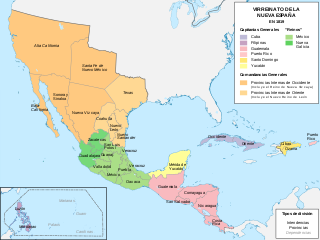
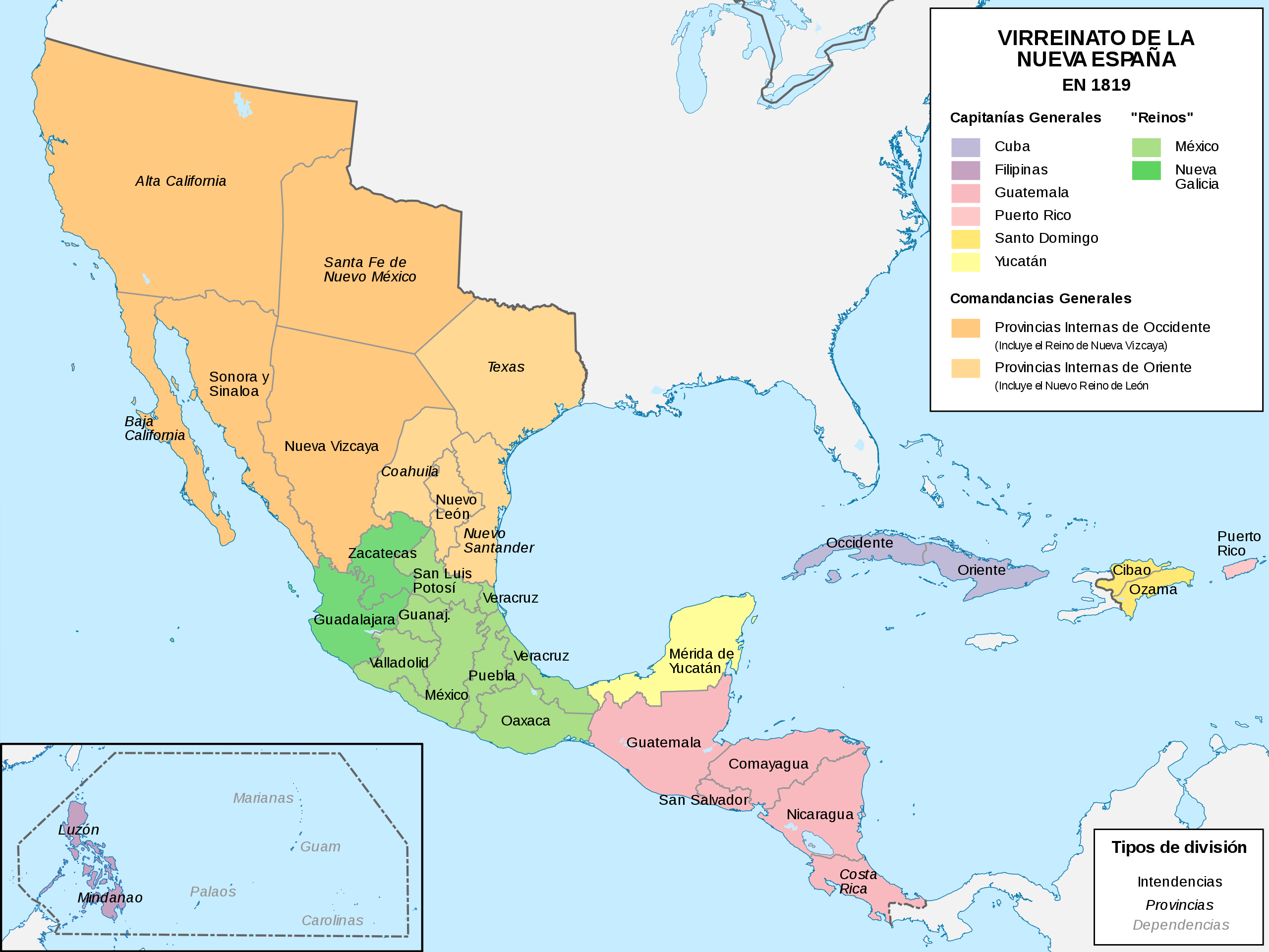
Español: Mapa político del Virreinato de la Nueva España (1819) |
| Date | |
| Source |
Own work |
| Author | Milenioscuro |
| Other versions |
|
.svg)
.svg)
.svg&action=edit§ion=1)
.JPG)
Licensing
[edit].svg&action=edit§ion=2)
I, the copyright holder of this work, hereby publish it under the following license:
This file is licensed under the Creative Commons Attribution-Share Alike 4.0 International license.
- You are free:
- to share – to copy, distribute and transmit the work
- to remix – to adapt the work
- Under the following conditions:
- attribution – You must give appropriate credit, provide a link to the license, and indicate if changes were made. You may do so in any reasonable manner, but not in any way that suggests the licensor endorses you or your use.
- share alike – If you remix, transform, or build upon the material, you must distribute your contributions under the same or compatible license as the original.
File history
Click on a date/time to view the file as it appeared at that time.
| Date/Time | Thumbnail | Dimensions | User | Comment | |
|---|---|---|---|---|---|
| current | 10:58, 13 November 2018 | | 885 × 664 (1.06 MB) | Milenioscuro (talk | contribs) | User created page with UploadWizard |
You cannot overwrite this file.
File usage on Commons
The following 5 pages use this file:
.png)
.png)
File usage on other wikis
The following other wikis use this file:
- Usage on af.wikipedia.org
- Usage on ar.wikipedia.org
- Usage on ast.wikipedia.org
- Usage on azb.wikipedia.org
- Usage on be-tarask.wikipedia.org
- Usage on be.wikipedia.org
- Usage on br.wikipedia.org
- Usage on ca.wikipedia.org
- Usage on cs.wikipedia.org
- Usage on de.wikipedia.org
- Usage on en.wikipedia.org
- Usage on es.wikipedia.org
- Demografía de México
- Suroeste de Estados Unidos
- Reino de Nueva Vizcaya
- Mexicanos
- Comandancia General de las Provincias Internas
- Organización territorial del Virreinato de Nueva España
- Intendencia de Guadalajara
- Portal:Nueva España/La foto del mes
- Historia territorial del Estado de México
- Conflicto entre Guatemala y México de 1842 y 1882
- Virreinato de Nueva España
- Regionalización de la Nueva España y división territorial de México
- Texas (Nueva España)
- Anexo:Gobernantes de las Californias
- Guerras indias de Texas
- Reino de México
View more global usage of this file.
.svg)
Metadata
.svg&oldid=909046947)
Categories:
- Maps of subdivisions of the Viceroyalty of New Spain
- Maps of the history of the United States
- Maps of old administrative divisions of Mexico
- Maps of colonial California
- Maps of the Captaincy General of Cuba
- SVG maps of the Viceroyalty of New Spain
- Spanish-language SVG maps showing history of North America
- SVG maps of the history of Mexico
- Territorial evolution of Mexico
- Texas–Indian Wars
- 1819 maps of North America
- Maps showing 1819
- Colonial New Mexico
- Maps of Spanish Texas
- New Kingdom of León