File:Mapa del Metrorrey (futuro).svg
Jump to navigation
Jump to search

Size of this PNG preview of this SVG file: 580 × 600 pixels. Other resolutions: 232 × 240 pixels | 464 × 480 pixels | 743 × 768 pixels | 990 × 1,024 pixels | 1,981 × 2,048 pixels | 2,734 × 2,827 pixels.
Original file (SVG file, nominally 2,734 × 2,827 pixels, file size: 803 KB)
Captions
Captions
Add a one-line explanation of what this file represents
Summary
[edit].svg&action=edit§ion=1)
| Description |
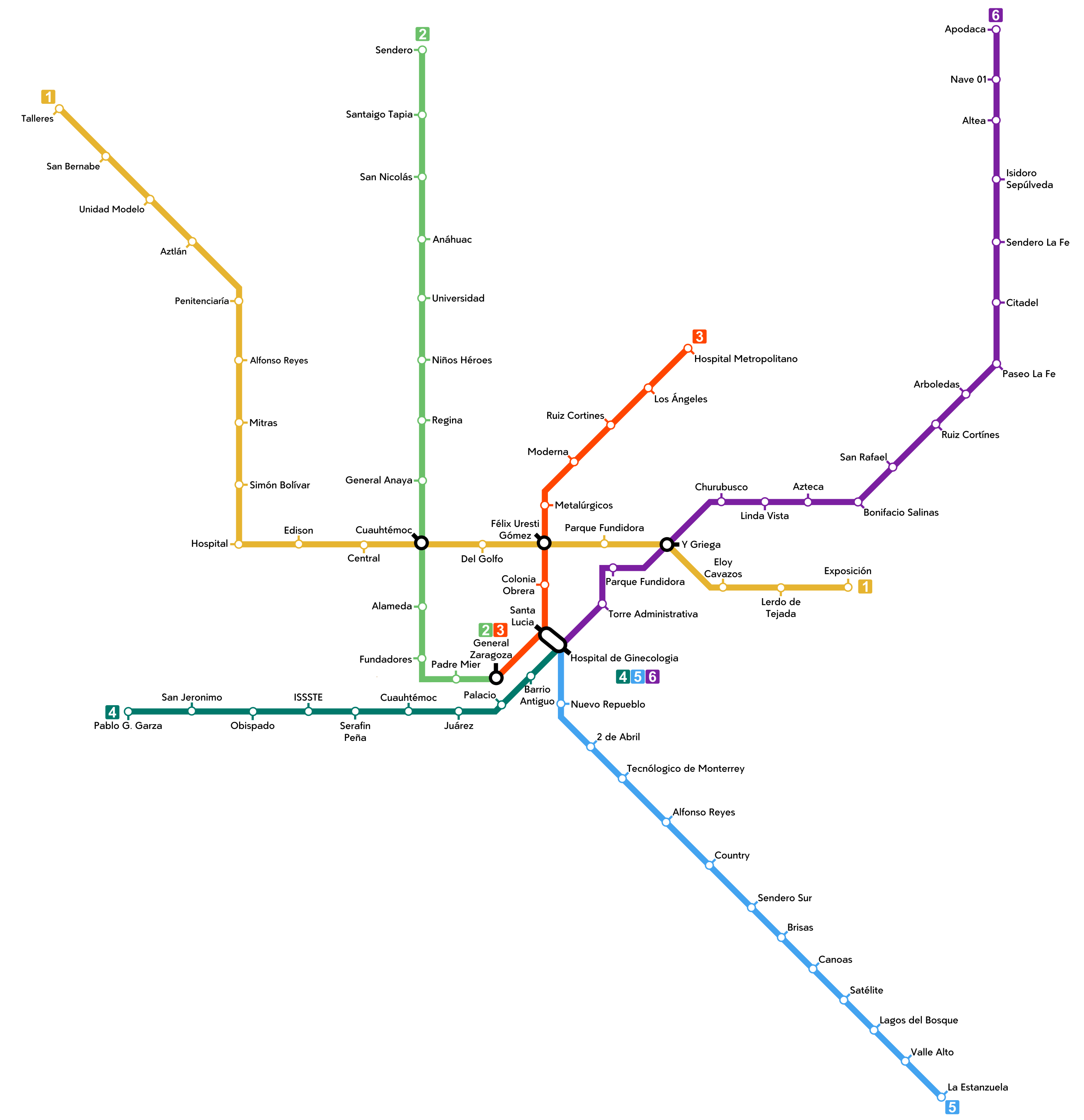
Español: Mapa de Metrorrey incluyendo los proyectos de las líneas 4, 5 y 6. |
| Date | |
| Source | Own work |
| Author | ManuelContreras1996 |
Licensing
[edit].svg&action=edit§ion=2)
I, the copyright holder of this work, hereby publish it under the following license:
This file is licensed under the Creative Commons Attribution-Share Alike 4.0 International license.
- You are free:
- to share – to copy, distribute and transmit the work
- to remix – to adapt the work
- Under the following conditions:
- attribution – You must give appropriate credit, provide a link to the license, and indicate if changes were made. You may do so in any reasonable manner, but not in any way that suggests the licensor endorses you or your use.
- share alike – If you remix, transform, or build upon the material, you must distribute your contributions under the same or compatible license as the original.
File history
Click on a date/time to view the file as it appeared at that time.
| Date/Time | Thumbnail | Dimensions | User | Comment | |
|---|---|---|---|---|---|
| current | 18:47, 11 February 2023 | | 2,734 × 2,827 (803 KB) | ManuelContreras1996 (talk | contribs) | tamaño |
| 22:34, 15 January 2023 |  | 2,736 × 2,827 (844 KB) | ManuelContreras1996 (talk | contribs) | Corrección de letras | |
| 21:39, 15 January 2023 |  | 2,736 × 2,827 (439 KB) | ManuelContreras1996 (talk | contribs) | Corrección de errores | |
| 21:24, 15 January 2023 |  | 2,727 × 2,843 (257 KB) | ManuelContreras1996 (talk | contribs) | arregalado | |
| 21:22, 15 January 2023 |  | 2,727 × 2,843 (256 KB) | ManuelContreras1996 (talk | contribs) | uptade | |
| 01:56, 12 January 2023 |  | 2,864 × 2,783 (84 KB) | ManuelContreras1996 (talk | contribs) | numero de lineas | |
| 01:46, 12 January 2023 |  | 2,864 × 2,721 (78 KB) | ManuelContreras1996 (talk | contribs) | uptade | |
| 01:48, 17 October 2022 |  | 5,312 × 5,921 (908 KB) | ManuelContreras1996 (talk | contribs) | uptade | |
| 16:23, 2 May 2022 |  | 3,139 × 3,827 (4 MB) | ManuelContreras1996 (talk | contribs) | Uploaded own work with UploadWizard |
You cannot overwrite this file.
File usage on Commons
The following 8 pages use this file:
- User:Chumwa/OgreBot/Public transport information/2022 May 1-10
- User:Chumwa/OgreBot/Public transport information/2022 October 11-20
- User:Chumwa/OgreBot/Public transport information/2023 February 10-18
- User:Chumwa/OgreBot/Public transport information/2023 January 11-20
- User:Chumwa/OgreBot/Transport Maps/2022 May 1-10
- User:Chumwa/OgreBot/Transport Maps/2022 October 11-20
- User:Chumwa/OgreBot/Transport Maps/2023 February 10-18
- User:Chumwa/OgreBot/Transport Maps/2023 January 11-20
File usage on other wikis
The following other wikis use this file:
- Usage on es.wikipedia.org
.svg&oldid=731811955)