File:Mapa de la Via Augusta.svg
Jump to navigation
Jump to search

Size of this PNG preview of this SVG file: 719 × 599 pixels. Other resolutions: 288 × 240 pixels | 576 × 480 pixels | 922 × 768 pixels | 1,229 × 1,024 pixels | 2,457 × 2,048 pixels | 1,261 × 1,051 pixels.
Original file (SVG file, nominally 1,261 × 1,051 pixels, file size: 562 KB)
Captions
Captions
Add a one-line explanation of what this file represents
Summary
[edit]
| Description |
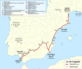
Català: Mapa de la Via Augusta Deutsch: Karte der Via Augusta im römischen Spanien zwischen Cádiz und Narbonne. English: Map of Via Augusta in Roman Hispania, between Cadiz and Narbonne. Español: Mapa de la Via Augusta en la Hispania romana, entre Cádiz y Narbona. Français : Carte de la Via Augusta en Hispanie romaine, entre Cadix et Narbonne. |
| Date | |
| Source |
This file was derived from: Via Augusta map-fr.svg: |
| Author |
|
| This is a retouched picture, which means that it has been digitally altered from its original version. Modifications: translated to Catalan. The original can be viewed here: Via Augusta map-fr.svg:
|

|
This file has been superseded by Via Augusta.svg. It is recommended to use the other file. Please note that deleting superseded images requires consent.
|

|
Licensing
[edit]
I, the copyright holder of this work, hereby publish it under the following licenses:
This file is licensed under the Creative Commons Attribution-Share Alike 3.0 Unported, 2.5 Generic, 2.0 Generic and 1.0 Generic license.
- You are free:
- to share – to copy, distribute and transmit the work
- to remix – to adapt the work
- Under the following conditions:
- attribution – You must give appropriate credit, provide a link to the license, and indicate if changes were made. You may do so in any reasonable manner, but not in any way that suggests the licensor endorses you or your use.
- share alike – If you remix, transform, or build upon the material, you must distribute your contributions under the same or compatible license as the original.
| Copyleft: This work of art is free; you can redistribute it and/or modify it according to terms of the Free Art License. You will find a specimen of this license on the Copyleft Attitude site as well as on other sites. |
You may select the license of your choice.
Original upload log
[edit]
This image is a derivative work of the following images:
- File:Via_Augusta_map-fr.svg licensed with Cc-by-sa-3.0,2.5,2.0,1.0, FAL
- 2011-07-27T08:12:03Z Sémhur 1261x1051 (567874 Bytes)
Uploaded with derivativeFX
File history
Click on a date/time to view the file as it appeared at that time.
| Date/Time | Thumbnail | Dimensions | User | Comment | |
|---|---|---|---|---|---|
| current | 21:42, 10 August 2012 | | 1,261 × 1,051 (562 KB) | Arnaugir (talk | contribs) | typo in Braga |
| 21:38, 10 August 2012 |  | 1,261 × 1,051 (562 KB) | Arnaugir (talk | contribs) | == {{int:filedesc}} == {{Information |Description={{Multilingual description |ca=Mapa de la ca:Via Augusta |de= Karte der Via Augusta im römischen Spanien zwischen Cádiz und Narbonne. |en= Map of [[:en:Via Augusta|Via Augus... |
You cannot overwrite this file.
File usage on Commons
The following page uses this file:
File usage on other wikis
The following other wikis use this file:
- Usage on ca.wikipedia.org
- Usage on gl.wikipedia.org