File:Mapa de la América española (1800).png
Jump to navigation
Jump to search

Size of this preview: 465 × 600 pixels. Other resolutions: 186 × 240 pixels | 372 × 480 pixels | 595 × 768 pixels | 794 × 1,024 pixels | 1,365 × 1,761 pixels.
Original file (1,365 × 1,761 pixels, file size: 175 KB, MIME type: image/png)
Captions
Captions
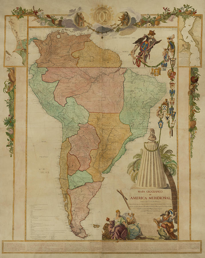
Map of Spanish America, showing provinces ca. 1800. Viceroyalty of New Spain in pink; Viceroyalty of New Granada in green; viceroyalty of Peru coral; viceroyalty Rio de la Plata blue.
Summary
[edit].png&action=edit§ion=1)
.JPG)
_-_Carta_V_-_Divisi%C3%B3n_pol%C3%ADtica_del_Virreinato_de_Santaf%C3%A9,_1810.jpg)
.svg)
.svg)
.jpg)
Licensing
[edit].png&action=edit§ion=2)
I, the copyright holder of this work, hereby publish it under the following license:
This file is licensed under the Creative Commons Attribution-Share Alike 3.0 Unported license.
- You are free:
- to share – to copy, distribute and transmit the work
- to remix – to adapt the work
- Under the following conditions:
- attribution – You must give appropriate credit, provide a link to the license, and indicate if changes were made. You may do so in any reasonable manner, but not in any way that suggests the licensor endorses you or your use.
- share alike – If you remix, transform, or build upon the material, you must distribute your contributions under the same or compatible license as the original.
File history
Click on a date/time to view the file as it appeared at that time.
.png&dir=prev)
.png&offset=20230102002513)
.png&offset=&limit=20)
.png&offset=&limit=50)
.png&offset=&limit=100)
.png&offset=&limit=250)
.png&offset=&limit=500)
| Date/Time | Thumbnail | Dimensions | User | Comment | |
|---|---|---|---|---|---|
| current | 03:39, 22 April 2023 | | 1,365 × 1,761 (175 KB) | Milenioscuro (talk | contribs) | voy a pedir la proteccion de este archivo, si desean hacer sus propias versiones, subanla en OTRO ARCHIVO |
| 19:46, 19 April 2023 |  | 1,365 × 1,761 (174 KB) | Floppa Historico (talk | contribs) | Reverted to version as of 03:35, 16 April 2023 (UTC) | |
| 10:53, 17 April 2023 |  | 1,365 × 1,761 (175 KB) | Milenioscuro (talk | contribs) | Reverted to version as of 22:54, 8 March 2023 (UTC) | |
| 03:35, 16 April 2023 |  | 1,365 × 1,761 (174 KB) | Floppa Historico (talk | contribs) | Reverted to version as of 15:39, 8 March 2023 (UTC) todo esta con pruebas | |
| 22:54, 8 March 2023 |  | 1,365 × 1,761 (175 KB) | Milenioscuro (talk | contribs) | Reverted to version as of 02:37, 16 January 2023 (UTC) A ver, el mapa es mio, hecho con fuentes consultadas por MI, si requieren imprimir esos cambios sacados de la nada, suban otro mapa | |
| 15:39, 8 March 2023 |  | 1,365 × 1,761 (174 KB) | Floppa Historico (talk | contribs) | Reverted to version as of 19:17, 7 January 2023 (UTC) | |
| 02:37, 16 January 2023 |  | 1,365 × 1,761 (175 KB) | Milenioscuro (talk | contribs) | Reverted to version as of 00:25, 2 January 2023 (UTC) desde cuando España poseía la Patagonia? y encima perteneciendo a Chile? claro | |
| 19:17, 7 January 2023 |  | 1,365 × 1,761 (174 KB) | Floppa Historico (talk | contribs) | Fixed misiones, Guatemala and smalls errors | |
| 01:56, 7 January 2023 |  | 1,365 × 1,761 (174 KB) | Floppa Historico (talk | contribs) | Fixed Chile, essequibo anda paraguay. :D | |
| 00:25, 2 January 2023 |  | 1,365 × 1,761 (175 KB) | Floppa Historico (talk | contribs) | All fixed based on https://dataverse.harvard.edu/dataset.xhtml?persistentId=doi:10.7910/DVN/YPEU5E of http://www.hgis-indias.net/ |
You cannot overwrite this file.
File usage on Commons
There are no pages that use this file.
File usage on other wikis
The following other wikis use this file:
- Usage on ca.wikipedia.org
- Usage on en.wikipedia.org
- Usage on es.wikipedia.org
- Usage on fr.wikipedia.org
- Usage on hu.wikipedia.org
- Usage on pt.wikipedia.org
- Usage on uz.wikipedia.org
- Usage on vi.wikipedia.org
.png&oldid=796766456)