File:Mapa de Zacapa.jpg

Original file (1,980 × 1,570 pixels, file size: 697 KB, MIME type: image/jpeg)
Captions
Captions
Summary
[edit]
| Description |
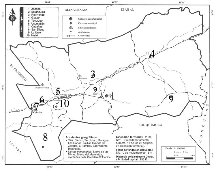
Español: Imagen digitalizada del departamento de Zacapa con sus 10 municipios. debidamente localizados, por mi ya que la publicación original no contenía localización. |
| Date | |
| Source | Own work Editorial Piedra Santa. Guatemala |
| Author | Maxmarvin |
Este mapa ha sido producto de un escaneo y luego se ha agregado los números a cada municipio, ya que hacían falta en la publicación original. La publicación original es de Editorial Piedra Santa y este mapa lo venden en las librerías del país de Gautemala por un valor de 0.25 centavos de quetzal.
Licensing
[edit]

|
Permission is granted to copy, distribute and/or modify this document under the terms of the GNU Free Documentation License, Version 1.2 or any later version published by the Free Software Foundation; with no Invariant Sections, no Front-Cover Texts, and no Back-Cover Texts. A copy of the license is included in the section entitled GNU Free Documentation License. |
- You are free:
- to share – to copy, distribute and transmit the work
- to remix – to adapt the work
- Under the following conditions:
- attribution – You must give appropriate credit, provide a link to the license, and indicate if changes were made. You may do so in any reasonable manner, but not in any way that suggests the licensor endorses you or your use.
- share alike – If you remix, transform, or build upon the material, you must distribute your contributions under the same or compatible license as the original.
Este mapa ha sido producto de un escaneo y luego se ha agregado los números a cada municipio, ya que hacían falta en la publicación original. La publicación original es de Editorial Piedra Santa y este mapa lo venden en las librerías del país de Guatemala por un valor de 0.25 centavos de quetzal.
File history
Click on a date/time to view the file as it appeared at that time.
| Date/Time | Thumbnail | Dimensions | User | Comment | |
|---|---|---|---|---|---|
| current | 23:56, 28 March 2011 | | 1,980 × 1,570 (697 KB) | Maxmarvin~commonswiki (talk | contribs) | {{Information |Description ={{es|1=Imagen digitalizada del departamento de Zacapa con sus 10 municipios. debidamente localizados, por mi ya que la publicación original no contenía localización. }} |Source ={{own}} Editorial Piedra Santa. Gua |
You cannot overwrite this file.
File usage on Commons
There are no pages that use this file.
File usage on other wikis
The following other wikis use this file:
- Usage on ca.wikipedia.org
- Usage on es.wikipedia.org
- Usage on lad.wikipedia.org