File:Mapa antigo de Olinda e Recife século XVI.png
Jump to navigation
Jump to search

Size of this preview: 397 × 599 pixels. Other resolutions: 159 × 240 pixels | 477 × 720 pixels.
Original file (477 × 720 pixels, file size: 756 KB, MIME type: image/png)
Captions
Captions
Add a one-line explanation of what this file represents
Summary
[edit]
| Description |
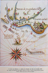
Português: A vila de Olinda e o porto do Recife no fim do século XVI.
Do códice da Biblioteca da Ajuda: Roteiro de todos os sinais, conhecimentos, fundos, baixos, alturas que há na costa do Brasil. |
| Date | 16th century |
| Source | http://www2.senado.leg.br/bdsf/item/id/220524 |
| Author | Do códice da Biblioteca da Ajuda: Roteiro de todos os sinais, conhecimentos, fundos, baixos, alturas que há na costa do Brasil. |
Licensing
[edit]
|
This work is in the public domain in its country of origin and other countries and areas where the copyright term is the author's life plus 70 years or fewer. This work is in the public domain in the United States because it was published (or registered with the U.S. Copyright Office) before January 1, 1929. | |
| This file has been identified as being free of known restrictions under copyright law, including all related and neighboring rights. | |
File history
Click on a date/time to view the file as it appeared at that time.
| Date/Time | Thumbnail | Dimensions | User | Comment | |
|---|---|---|---|---|---|
| current | 23:43, 19 July 2015 | | 477 × 720 (756 KB) | Robertolyra (talk | contribs) | User created page with UploadWizard |
You cannot overwrite this file.
File usage on Commons
There are no pages that use this file.
File usage on other wikis
The following other wikis use this file:
- Usage on it.wikipedia.org
- Usage on pt.wikipedia.org