File:Mapa Virreinato del Río de la Plata (año 1800) por Agustín Antonio Cabrera Cardozo.png
Jump to navigation
Jump to search
Size of this preview: 800 × 450 pixels. Other resolutions: 320 × 180 pixels | 640 × 360 pixels | 1,024 × 576 pixels | 1,280 × 720 pixels | 2,560 × 1,440 pixels | 3,840 × 2,160 pixels.
Original file (3,840 × 2,160 pixels, file size: 903 KB, MIME type: image/png)
Captions
Captions
Add a one-line explanation of what this file represents
Summary
[edit]_por_Agust%C3%ADn_Antonio_Cabrera_Cardozo.png&action=edit§ion=1)
| Description |
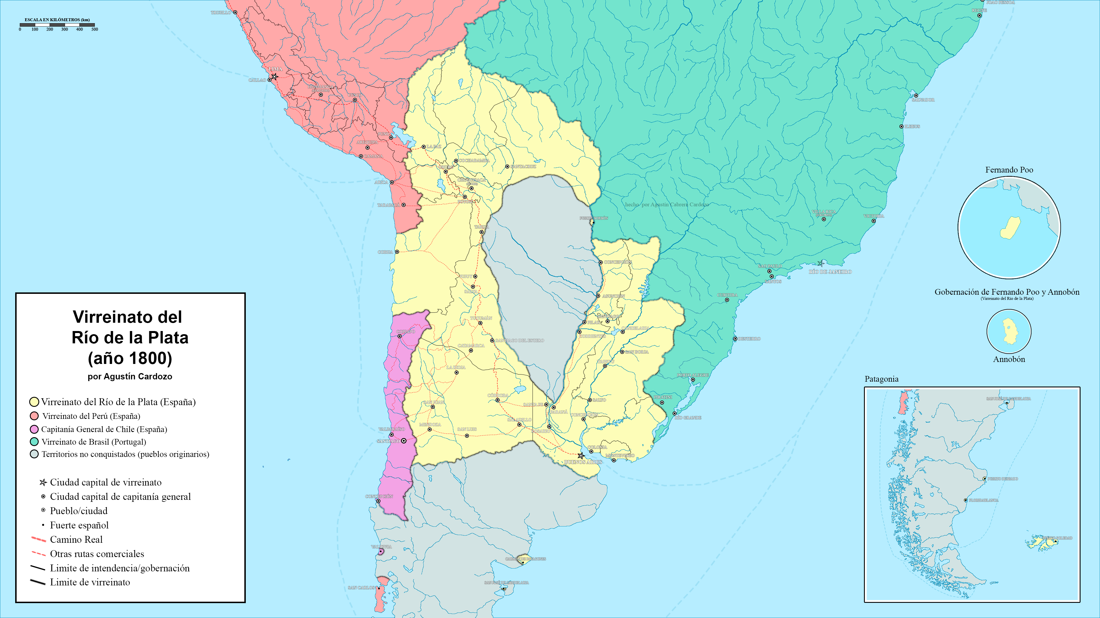
Español: Amarillo - Virreinato del Río de la Plata; Rojo - Virreinato del Perú; Violeta - Capitanía General de Chile; Verde - Brasil portugués; Gris - territorios no conquistados (pueblos originarios)
Trazos rojos punteados - rutas comerciales Trazos punteados en el océano - rutas marítimas |
| Date | |
| Source | Own work |
| Author | Agustín Antonio Cardozo |
Licensing
[edit]_por_Agust%C3%ADn_Antonio_Cabrera_Cardozo.png&action=edit§ion=2)
I, the copyright holder of this work, hereby publish it under the following license:
This file is licensed under the Creative Commons Attribution-Share Alike 4.0 International license.
- You are free:
- to share – to copy, distribute and transmit the work
- to remix – to adapt the work
- Under the following conditions:
- attribution – You must give appropriate credit, provide a link to the license, and indicate if changes were made. You may do so in any reasonable manner, but not in any way that suggests the licensor endorses you or your use.
- share alike – If you remix, transform, or build upon the material, you must distribute your contributions under the same or compatible license as the original.
File history
Click on a date/time to view the file as it appeared at that time.
| Date/Time | Thumbnail | Dimensions | User | Comment | |
|---|---|---|---|---|---|
| current | 22:46, 6 July 2022 | | 3,840 × 2,160 (903 KB) | Agustín Cardozo Cabrera (talk | contribs) | Uploaded own work with UploadWizard |
You cannot overwrite this file.
File usage on Commons
There are no pages that use this file.
File usage on other wikis
The following other wikis use this file:
- Usage on fr.wikipedia.org
_por_Agustín_Antonio_Cabrera_Cardozo.png&oldid=843985452)